Category:Kagel
Deutsch: Das Dorf Kagel gehört zur Gemeinde Grünheide (Mark) , Landkreis Oder-Spree , Land Brandenburg, Deutschland.
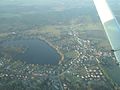
English: The village Kagel belongs to Grünheide (Mark) municipality , Oder-Spree district, Brandenburg state, Germany
Français : Le village de Kagel fait partie de la commune de Grünheide (Mark) , arrondissement de Oder-Spree , état fédéral de Brandebourg, Allemagne
Español: El pueblo de Kagel es parte del municipio de Grünheide (Mark) , distrito de Oder-Spree , estado federado de Brandeburgo, Alemania
| Object location | | View all coordinates using: OpenStreetMap |
|---|
village in Brandenburg state, Germany  La chiesa  | |||||
| Upload media | |||||
| Instance of |
| ||||
|---|---|---|---|---|---|
| Location | Grünheide (Mark), Oder-Spree District, Brandenburg, Germany | ||||
| Elevation above sea level |
| ||||
 | |||||
Subcategories
This category has the following 6 subcategories, out of 6 total.
Media in category "Kagel"
The following 5 files are in this category, out of 5 total.
-

-
 Finkenstein - Weg Zur Erholung - geo.hlipp.de - 43364.jpg 640 × 480; 146 KB
-
 Kagel - Finkenstein - geo.hlipp.de - 43369.jpg 640 × 480; 110 KB
-
 Kagel Luftbild.jpg 4,320 × 3,240; 1.52 MB
-
 Wappen Kagel.png 449 × 503; 126 KB
_-_geo.hlipp.de_-_43368.jpg)


