Category:Kaiserstraat 11, Leiden
| Object location | | View all coordinates using: OpenStreetMap |
|---|
 | |||||
| Upload media | |||||
| Instance of |
| ||||
|---|---|---|---|---|---|
| Location | Leiden, South Holland, Netherlands | ||||
| Street address |
| ||||
| Heritage designation |
| ||||
 | |||||
|
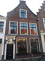
This is a category about rijksmonument number 24975
|
| Address |
|
Media in category "Kaiserstraat 11, Leiden"
The following 5 files are in this category, out of 5 total.
-
 Exterieur ACHTERGEVEL - Leiden - 20274422 - RCE.jpg 1,198 × 1,200; 359 KB
-
 Exterieur VOORGEVEL - Leiden - 20274421 - RCE.jpg 960 × 1,200; 276 KB
-
 Gevel - Leiden - 20136303 - RCE.jpg 802 × 1,200; 204 KB
-
 Leiden - Kaiserstraat 11.JPG 2,736 × 3,648; 4.06 MB
-
 Leiden - Kaiserstraat 11.jpg 3,325 × 4,762; 1.12 MB


