Category:Kapel aan Zee (Noordwijk)
| Object location | | View all coordinates using: OpenStreetMap |
|---|
protestant church  | |||||
| Upload media | |||||
| Instance of | |||||
|---|---|---|---|---|---|
| Location | Noordwijk, South Holland, Netherlands | ||||
| Street address |
| ||||
| Located on street |
| ||||
| Heritage designation |
| ||||
| Inception |
| ||||
| Religion or worldview | |||||
 | |||||
|
This is a category about rijksmonument number 30769
|
| Address |
|
Media in category "Kapel aan Zee (Noordwijk)"
The following 35 files are in this category, out of 35 total.
-
 Hoofdstraat en deel Jan Kroonsweg en Jan Kroonsplein 1 maart 1971.jpg 3,280 × 2,104; 1,003 KB
-
 Interieur naar het oosten - Noordwijk aan Zee - 20169699 - RCE.jpg 1,200 × 958; 172 KB
-
 Interieur naar het westen - Noordwijk aan Zee - 20169698 - RCE.jpg 1,200 × 958; 173 KB
-
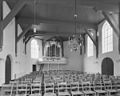
 Interieur, aanzicht orgel - Noordwijk aan Zee - 20356818 - RCE.jpg 956 × 1,200; 151 KB
-

-
 Jacob Braakman, Noord-boulevard 7, 1890, Noordwijk aan Zee.jpg 3,248 × 2,096; 2.03 MB
-
 Kapel aan Zee (Noordwijk) (1).jpg 2,677 × 2,440; 1.49 MB
-
 Kapel aan Zee (Noordwijk) (2).jpg 3,030 × 2,680; 1.21 MB
-
 Kapel aan Zee (Noordwijk) (3).jpg 3,016 × 2,651; 1.58 MB
-
 Kapel aan Zee (Noordwijk) (4).jpg 3,063 × 2,614; 1.77 MB
-
 Kapel aan Zee (Noordwijk) (5).jpg 4,000 × 2,591; 1.25 MB
-
 Kerk - Noordwijk aan Zee - 20169696 - RCE.jpg 807 × 1,200; 172 KB
-

-
-

-
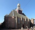
 Nederlands Hervormde kerk - Noordwijk aan Zee - 20169704 - RCE.jpg 947 × 1,200; 219 KB
-
 Noordwijk kerk aan zee compleet v2.jpg 2,736 × 3,648; 4.27 MB
-
 Noordwijk kerk aan zee compleet v3.jpg 2,736 × 3,648; 4.23 MB
-
 Noordwijk kerk aan zee compleet v4.jpg 2,736 × 3,648; 4.31 MB
-
 Noordwijk kerk aan zee compleet v5.jpg 3,648 × 2,736; 4.56 MB
-
 Noordwijk kerk aan zee compleet.jpg 3,648 × 2,736; 4.52 MB
-
 Noordwijk kerk aan zee.jpg 2,736 × 3,648; 3.78 MB
-
 Noordwijk, houses at the Parallel Boulevard.jpg 2,551 × 1,701; 1.06 MB
-
 Orgel - Noordwijk aan Zee - 20169701 - RCE.jpg 955 × 1,200; 175 KB
-
 Overzicht westgevel en noordgevel - Noordwijk aan Zee - 20365873 - RCE.jpg 926 × 1,200; 190 KB
-
 Overzicht westgevel met ingangspartij - Noordwijk aan Zee - 20365872 - RCE.jpg 926 × 1,200; 193 KB
-
 Plattegrond en opstand, Hs.Verhees - Noordwijk aan Zee - 20169690 - RCE.jpg 866 × 1,200; 203 KB
-
 Preekstoel - Noordwijk aan Zee - 20169695 - RCE.jpg 911 × 1,200; 207 KB
-
 Preekstoel - Noordwijk aan Zee - 20169700 - RCE.jpg 954 × 1,200; 167 KB
-

-
 Uitwendig - Noordwijk aan Zee - 20169694 - RCE.jpg 1,200 × 945; 215 KB
-
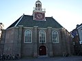
 Voorzijde - Noordwijk aan Zee - 20169702 - RCE.jpg 955 × 1,200; 240 KB
-
 Voorzijde exterieur - Noordwijk aan Zee - 20169703 - RCE.jpg 953 × 1,200; 251 KB
-
 Zicht over Noordwijk aan Zee.jpg 2,400 × 1,800; 2.98 MB
-
 Zuid gevel, interieur - Noordwijk aan Zee - 20169697 - RCE.jpg 1,200 × 959; 161 KB


_(1).jpg)
_(2).jpg)
_(3).jpg)
_(4).jpg)
_(5).jpg)


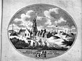
_in-_Kabinet_van_Nederlandse_en_Kleefse_Oudheden_II,_145_-_Noordwijk_aan_Zee_-_20169691_-_RCE.jpg)


