Category:Kapellestraat 24, Oudewater
| Object location | | View all coordinates using: OpenStreetMap |
|---|
 | |||||
| Upload media | |||||
| Instance of | |||||
|---|---|---|---|---|---|
| Location | Oudewater, South Holland, Netherlands | ||||
| Street address |
| ||||
| Located on street | |||||
| Heritage designation |
| ||||
 | |||||
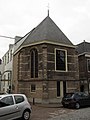
Nederlands: Voormalige Ursulakapel
|
This is a category about rijksmonument number 32030
|
| Address |
|
Media in category "Kapellestraat 24, Oudewater"
The following 7 files are in this category, out of 7 total.
-
 3421 Oudewater, Netherlands - panoramio (33).jpg 2,048 × 1,148; 524 KB
-
 RM32030 Oudewater - Kapellestraat 24.jpg 1,944 × 2,592; 1.1 MB
-
 Voorgevels (24 is voormalige Kapel) - Oudewater - 20179908 - RCE.jpg 1,200 × 805; 168 KB
-
 Voormalige Ursulakapel, noordgevel - Oudewater - 20179912 - RCE.jpg 1,186 × 1,200; 402 KB
-
 Voormalige Ursulakapel, oostgevel - Oudewater - 20179909 - RCE.jpg 1,192 × 1,200; 327 KB
-
 Voormalige Ursulakapel, zuid-oost gevel - Oudewater - 20179910 - RCE.jpg 1,188 × 1,200; 285 KB
-
 Voormalige Ursulakapel, zuidgevel - Oudewater - 20179911 - RCE.jpg 1,200 × 1,200; 432 KB
.jpg)
_-_Oudewater_-_20179908_-_RCE.jpg)


