Category:Kapelluddens fyr
| Object location | | View all coordinates using: OpenStreetMap |
|---|
|
This is a category about a historic building in Sweden, number 21300000012337 in the RAÄ buildings database.
|
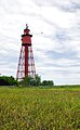
English: Kapelludden lighthouse
lighthouse in Borgholm Municipality, Baltic coast, Sweden  | |||||
| Upload media | |||||
| Instance of |
| ||||
|---|---|---|---|---|---|
| Made from material | |||||
| Location | Kapelludden, Borgholm Municipality, Kalmar County, Sweden | ||||
| Located in or next to body of water | |||||
| Architect | |||||
| Heritage designation |
| ||||
| Inception |
| ||||
| Significant event |
| ||||
| Source of energy |
| ||||
| Height |
| ||||
 | |||||
Media in category "Kapelluddens fyr"
The following 8 files are in this category, out of 8 total.
-
 Kapelludden - lighthouse and chapel ruins.jpg 2,439 × 3,257; 2.54 MB
-
 Kapelludden - lighthouse and farming equipment.jpg 3,040 × 2,115; 1.6 MB
-
 Kapelludden - lighthouse and swift.jpg 1,873 × 3,030; 1.07 MB
-
 Kapelludden - lighthouse through archway.jpg 2,290 × 2,731; 1.95 MB
-
 Kapelludden lighthouse.jpg 3,968 × 2,976; 4.17 MB
-
 Kappelluddens fyr tagen genom ruinen.jpg 4,000 × 4,000; 13.28 MB
-
 Leuchtturm auf Kapelludden.JPG 1,195 × 1,852; 270 KB
-
 Oeland lighthouse Kapelludden.jpg 3,220 × 2,414; 2.87 MB


