Category:Kapuzinerkloster Solothurn
| Object location | | View all coordinates using: OpenStreetMap |
|---|
Deutsch: Ehemaliges Kapuzinerkloster Solothurn
English: Former Capuchin Friary of Solothurn, Switzerland.
monastery building in the city of Solothurn, Switzerland   | |||||
| Upload media | |||||
| Instance of | |||||
|---|---|---|---|---|---|
| Part of | |||||
| Location | Solothurn, Solothurn District, Solothurn-Lebern, Solothurn, Switzerland | ||||
| Street address |
| ||||
| Heritage designation | |||||
 | |||||
Media in category "Kapuzinerkloster Solothurn"
The following 47 files are in this category, out of 47 total.
-
 04-kapuziner-klosterkirche.jpg 2,560 × 1,920; 1,019 KB
-
 2014-05-12 Solothurn 19.jpg 3,240 × 4,320; 5.77 MB
-
 2014-05-12 Solothurn 20.jpg 3,240 × 4,320; 5.31 MB
-
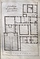 Architectura Capucinorum 06r.jpg 1,056 × 1,571; 706 KB
-
 Architectura Capucinorum 06v.jpg 1,069 × 1,601; 746 KB
-
 Baum kapuziner solothurn.JPG 2,560 × 1,920; 2.38 MB
-
 Baum Kapuziner Solothurn.jpg 2,560 × 1,920; 3.82 MB
-
 Kapuziner-altarbild-seghers.jpg 2,448 × 3,264; 2.45 MB
-
 Kapuzinerkloster SO essraummg 1814.jpg 3,392 × 2,736; 1.47 MB
-
 Kapuzinerkloster Solothurn - Hochaltar - HDR.jpg 2,660 × 4,390; 4.73 MB
-
 Kapuzinerkloster Solothurn - Kirche Hochaltarbild HDR.jpg 2,500 × 3,767; 4.64 MB
-
 Kapuzinerkloster Solothurn - Kirche urspruenglicher Chor HDR.jpg 2,000 × 3,000; 2.32 MB
-
 Kapuzinerkloster Solothurn - Kirchenchor aussen HDR.jpg 2,600 × 4,000; 3.35 MB
-
 Kapuzinerkloster Solothurn - Kirchenfenster.jpg 2,460 × 5,185; 4.07 MB
-
 Kapuzinerkloster Solothurn - Kirchenschiff - HDR.jpg 4,200 × 2,800; 4.11 MB
-
 Kapuzinerkloster Solothurn - Kreuzgang Innenhof 2.jpg 2,650 × 4,000; 6.69 MB
-
 Kapuzinerkloster Solothurn - Kreuzgang Innenhof HDR.jpg 3,500 × 2,500; 4.22 MB
-
 Kapuzinerkloster Solothurn - Kreuzgang Innenhof.jpg 3,500 × 2,550; 6.08 MB
-
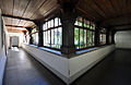 Kapuzinerkloster Solothurn - Kreuzgang.jpg 4,000 × 2,600; 3.57 MB
-
 Kapuzinerkloster Solothurn - Kreuzweg in der Kirche, Detailansicht.jpg 2,000 × 1,400; 1.1 MB
-
 Kapuzinerkloster Solothurn - Kreuzweg in der Kirche, erste sechs Stationen.jpg 3,370 × 1,960; 2.51 MB
-
 Kapuzinerkloster Solothurn - Küche 2.jpg 4,000 × 2,650; 3.06 MB
-
 Kapuzinerkloster Solothurn - Küche HDR Tone Mapping.jpg 4,010 × 2,660; 5.68 MB
-
 Kapuzinerkloster Solothurn - Küche HDR.jpg 4,010 × 2,660; 4.03 MB
-
 Kapuzinerkloster Solothurn - Küche Herd.jpg 4,010 × 2,550; 3 MB
-
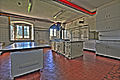
 Kapuzinerkloster Solothurn - Küche.jpg 4,010 × 2,660; 2.82 MB
-
 Kapuzinerkloster Solothurn - Lindenbäume - 01.jpg 3,000 × 2,627; 4.57 MB
-
 Kapuzinerkloster Solothurn - Lindenbäume - 02.jpg 2,848 × 4,288; 5.9 MB
-
 Kapuzinerkloster Solothurn - Pforte.jpg 3,180 × 2,000; 2.71 MB
-
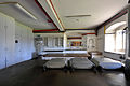
 Kapuzinerkloster Solothurn - Refektorium.jpg 4,218 × 2,478; 2.95 MB
-
 Kapuzinerkloster Solothurn - Seitenaltar - Christuskind, Josef von Nazaret.jpg 2,340 × 4,061; 3.94 MB
-
 Kapuzinerkloster Solothurn - Seitenaltar - Franziskus.jpg 2,316 × 4,139; 3.25 MB
-
 Kapuzinerkloster Solothurn - Seitenaltar - Maria mit Corpus Christi.jpg 2,274 × 4,110; 3.07 MB
-
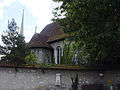
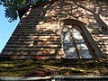
 Kapuzinerkloster Solothurn - Suedseite HDR.jpg 3,000 × 1,770; 3.14 MB
-
 Kapuzinerkloster Solothurn Kirche Westwand Detail.jpg 3,264 × 2,448; 2.06 MB
-
 Kapuzinerkloster Solothurn Kirche Westwand.jpg 3,264 × 2,448; 1.78 MB
-
 Kapuzinerkloster Solothurn Spengler 1659.jpg 365 × 349; 60 KB
-
 Kapuzinerkloster solothurn westteil.jpg 3,476 × 2,620; 1.44 MB
-
 Kapuzinerkloster-solothurn-lage.svg 978 × 756; 383 KB
-
 Kapuzinerklosterkueche SO.jpg 2,740 × 2,244; 961 KB
-
 Kapuzinerklosterosteil nov09.jpg 3,648 × 2,736; 1.25 MB
-
 Kapuzinerklostersolothurnnov09.jpg 3,648 × 2,736; 1.07 MB
-
 Kirche kapuziner solothurn.jpg 1,920 × 2,560; 1.4 MB
-
 Kreuzgang kapuziner solothurn.jpg 1,920 × 2,560; 1.85 MB
-
 Pforte kapuziner solothurn.jpg 2,560 × 1,920; 2.39 MB
-
 Sattler polsterer 1827.jpg 2,444 × 2,600; 805 KB
-
 Zentralbibliothek Solothurn - Die MaiandachtsKirche der Solothurner Kapuzinerkirche - a0967.tif 3,872 × 2,592; 28.74 MB


