Category:Kastell Lorch
| Object location | | View all coordinates using: OpenStreetMap |
|---|
Das Kastell Lorch ist ein ehemaliges römisches Militärlager, das nahe am Rätischen Limes, einem UNESCO-Weltkulturerbe, zur Grenzsicherung errichtet wurde.
Roman fort  | |||||
| Upload media | |||||
| Instance of | |||||
|---|---|---|---|---|---|
| Part of | |||||
| Location |
| ||||
| Heritage designation |
| ||||
| Area |
| ||||
| Elevation above sea level |
| ||||
 | |||||
Subcategories
This category has only the following subcategory.
E
- Evangelische Stadtkirche Lorch (23 F)
Media in category "Kastell Lorch"
The following 4 files are in this category, out of 4 total.
-
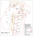 Kastell Lorch Mannschaftsbaracken 1987 (Italiano).png 2,953 × 3,295; 1.11 MB
-
 Kastell Lorch Mannschaftsbaracken 1987 (Română).png 2,953 × 3,295; 1.12 MB
-
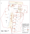 Kastell Lorch Mannschaftsbaracken 1987.png 2,953 × 3,295; 1.2 MB
-
 Kastell Lorch Turmfundament.jpeg 4,608 × 3,456; 4.87 MB
.png)
.png)
