Category:Kelshall
English: Kelshall is a small village in North East Hertfordshire, England. In fact due to its small size it can be classed as a hamlet. It is near the town Royston. It has a village hall and the local church is St. Faiths.
a village located in North Hertfordshire, United Kingdom | |||||
| Upload media | |||||
| Instance of | |||||
|---|---|---|---|---|---|
| Location | North Hertfordshire, Hertfordshire, East of England, England | ||||
| Population |
| ||||
| Said to be the same as | Kelshall (Wikimedia duplicated page, civil parish) | ||||
 | |||||
Subcategories
This category has only the following subcategory.
F
- St Faith's Church, Kelshall (8 F)
Media in category "Kelshall"
The following 77 files are in this category, out of 77 total.
-
 20th Century map of Kelshall.PNG 412 × 356; 308 KB
-
 A damp A505 - geograph.org.uk - 2101832.jpg 640 × 439; 41 KB
-
 A dangerous junction (A505) - geograph.org.uk - 2440034.jpg 640 × 431; 38 KB
-

-
 A505 - speed camera - geograph.org.uk - 5683368.jpg 640 × 428; 118 KB
-
 A505 - Therfield turning - geograph.org.uk - 2440030.jpg 640 × 431; 43 KB
-
 A505 dual carriageway at Therfield junction - geograph.org.uk - 5964666.jpg 1,600 × 794; 506 KB
-

-
 A505 heading north-east - geograph.org.uk - 5683356.jpg 640 × 428; 124 KB
-
 A505 heading north-east - geograph.org.uk - 5683378.jpg 640 × 428; 116 KB
-
 Approaching the filling station on Baldock Road - geograph.org.uk - 5385806.jpg 2,048 × 1,536; 1.47 MB
-
 Ashwell turning - A505 - geograph.org.uk - 2439518.jpg 640 × 416; 47 KB
-
 Balloon - Kelshall (6042791593).jpg 2,048 × 1,365; 293 KB
-

-
 BP filling station, Odsey Service Station - geograph.org.uk - 5964655.jpg 1,600 × 959; 611 KB
-
 Chain Walk - geograph.org.uk - 4208634.jpg 1,600 × 1,200; 1,021 KB
-

-
 Coombe Road - geograph.org.uk - 403204.jpg 640 × 480; 72 KB
-

-

-
 Economic activity in Kelshall.png 480 × 290; 7 KB
-
 Fears Green, Woodcotes - geograph.org.uk - 5790143.jpg 2,048 × 1,536; 1.72 MB
-
 Field near Lower Coombe Farm - geograph.org.uk - 403185.jpg 640 × 480; 60 KB
-
 Field of Rape near Heath Farm - geograph.org.uk - 403265.jpg 640 × 480; 97 KB
-
 Filling station, A505 - geograph.org.uk - 5203183.jpg 640 × 426; 35 KB
-
 Foxhall Cottage and Studio, Kelshall - geograph.org.uk - 3147803.jpg 640 × 425; 113 KB
-

-
 Heath Farm hidden by trees - geograph.org.uk - 403280.jpg 640 × 480; 39 KB
-
 Horses at Heath Farm - geograph.org.uk - 403289.jpg 640 × 507; 50 KB
-
 Horseshoe Wood Farm from Crouch Hill - geograph.org.uk - 403247.jpg 640 × 480; 64 KB
-
 Kelshall , village hall - geograph.org.uk - 6607359.jpg 1,024 × 771; 764 KB
-
 Kelshall Cross - geograph.org.uk - 4499.jpg 480 × 640; 126 KB
-
 Kelshall Cross and millennium monument - geograph.org.uk - 4526309.jpg 4,320 × 3,240; 4.61 MB
-
 Kelshall Cross and millennium monument - geograph.org.uk - 5783704.jpg 2,048 × 1,536; 1.44 MB
-
 Kelshall Cross and millennium monument - geograph.org.uk - 6585311.jpg 1,920 × 1,280; 1.34 MB
-
 Kelshall Farm - geograph.org.uk - 6588471.jpg 1,874 × 1,208; 1.31 MB
-
 Kelshall Farms entrance, Kelshall - geograph.org.uk - 3147792.jpg 640 × 425; 67 KB
-
 Line of trees on Thrift Hill - geograph.org.uk - 4624573.jpg 640 × 480; 131 KB
-
 Looking east towards Crouch Hill - geograph.org.uk - 403275.jpg 640 × 480; 47 KB
-
 Looking past Heath Farm to The A505 - geograph.org.uk - 2872339.jpg 640 × 425; 58 KB
-

-
 Lords Wood, south of Kelsall - geograph.org.uk - 517450.jpg 640 × 480; 85 KB
-
 Modern house on North End, Kelshall - geograph.org.uk - 5783716.jpg 1,952 × 1,400; 1.79 MB
-
 Mount Hill from near Stump Cross - geograph.org.uk - 403228.jpg 640 × 480; 48 KB
-
 North Hertfordshire , rape seed field - geograph.org.uk - 6623650.jpg 1,024 × 768; 728 KB
-
 North Hertfordshire farmland with deer - geograph.org.uk - 6607883.jpg 1,024 × 768; 840 KB
-
 Old farm machinery outside Heath Farm - geograph.org.uk - 403292.jpg 640 × 480; 104 KB
-

-
 Parking area on Royston Road, Odsey - geograph.org.uk - 5393121.jpg 2,304 × 1,728; 867 KB
-
 Path in Fears Green - geograph.org.uk - 6592710.jpg 1,850 × 1,164; 1.57 MB
-
 Phone box used as a book exchange, Kelshall - geograph.org.uk - 4527614.jpg 3,240 × 4,320; 2.91 MB
-
 Religious identity, 2001.png 480 × 290; 4 KB
-
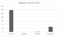 Religious identity, 2011.png 480 × 290; 5 KB
-

-
 Road junction in Kelshall - geograph.org.uk - 3571164.jpg 800 × 600; 162 KB
-

-

-
 Road on Crouch Hill - geograph.org.uk - 403252.jpg 640 × 480; 45 KB
-

-
 Shell petrol station on Baldock Road - geograph.org.uk - 5385805.jpg 2,048 × 1,536; 1.48 MB
-
 Stubble field by Kelshall Lane - geograph.org.uk - 4208639.jpg 1,600 × 1,200; 844 KB
-

-
 Sunset - Kelshall Therfield (6208281012).jpg 2,048 × 1,365; 82 KB
-
 Sunset at Kelshall, Herts (6043306262).jpg 2,048 × 1,365; 187 KB
-
 The Old Rectory, Kelshall - geograph.org.uk - 4526291.jpg 4,320 × 3,240; 5.84 MB
-

-
 The road to Therfield - geograph.org.uk - 5783719.jpg 1,976 × 1,434; 1.23 MB
-
 Therfield , water tower - geograph.org.uk - 6623601.jpg 2,444 × 1,721; 4.16 MB
-
 Therfield-Kelshall road signs - geograph.org.uk - 6596091.jpg 1,024 × 811; 612 KB
-
 Thrift Hill - geograph.org.uk - 403211.jpg 640 × 480; 77 KB
-
 Traffic on the A505 - geograph.org.uk - 4166667.jpg 640 × 321; 22 KB
-
 Traffic on the A505 - geograph.org.uk - 4166674.jpg 640 × 430; 38 KB
-
 Tree on Crouch Hill - geograph.org.uk - 403234.jpg 640 × 480; 73 KB
-
 View north from Coombe Road - geograph.org.uk - 4624590.jpg 640 × 480; 109 KB
-
 Wheat field - geograph.org.uk - 4624684.jpg 640 × 480; 127 KB
-
 Woodcotes, Fears Green - geograph.org.uk - 471666.jpg 640 × 480; 131 KB
-


_-_geograph.org.uk_-_2440034.jpg)


.jpg)


.jpg)
.jpg)


