Category:Kerk van Eenum
| Object location | | View all coordinates using: OpenStreetMap |
|---|
church building in Eenum, Netherlands   | |||||
| Upload media | |||||
| Instance of | |||||
|---|---|---|---|---|---|
| Dedicated to | |||||
| Location | Eenum, Eemsdelta, Groningen, Netherlands | ||||
| Street address |
| ||||
| Located on street |
| ||||
| Heritage designation |
| ||||
| Inception |
| ||||
| official website | |||||
 | |||||
|
This is a category about rijksmonument number 40300
|
| Address |
|
Subcategories
This category has only the following subcategory.
O
Media in category "Kerk van Eenum"
The following 82 files are in this category, out of 82 total.
-
 Andréastsjerke fan Eenum (Ienum) fanút it noardwêst.jpg 2,232 × 2,232; 2.67 MB
-
 Andréastsjerke fan Eenum (Ienum) fanút it súdeasten.jpg 2,252 × 2,560; 2.37 MB
-
 Andréastsjerke fan Eenum (Ienum), hearebank mei fykwurk.jpg 2,485 × 1,904; 1,006 KB
-
 Andréastsjerke fan Eenum (Ienum), ynrjochting.jpg 3,866 × 2,354; 2.32 MB
-
 Andréastsjerke fan Eenum (Ienum).jpg 1,986 × 1,432; 1.17 MB
-
 Andréastsjerke, Eenum.jpg 3,293 × 2,197; 3.51 MB
-
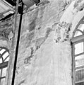
 Detail noordwand - Eenum - 20067610 - RCE.jpg 1,200 × 1,197; 304 KB
-
 Detail noordwand - Eenum - 20067611 - RCE.jpg 1,200 × 1,200; 310 KB
-
 Detail op westwand zuidkant - Eenum - 20067628 - RCE.jpg 1,200 × 1,197; 441 KB
-
 Detail schildering zuidwand 3e raam van af koorwand - Eenum - 20067624 - RCE.jpg 1,191 × 1,200; 386 KB
-
 Detail tekst noordwand bij orgel - Eenum - 20067616 - RCE.jpg 1,197 × 1,200; 437 KB
-
 Detail westzijde achter orgel - Eenum - 20067630 - RCE.jpg 1,200 × 1,192; 339 KB
-
 Dichtgezet raam noordzijde - Eenum - 20067620 - RCE.jpg 1,200 × 1,200; 359 KB
-
 Dichtgezette doorgang zuidzijde - Eenum - 20067626 - RCE.jpg 1,195 × 1,200; 315 KB
-
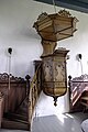 Eenum - kansel.jpg 3,905 × 5,857; 10.52 MB
-
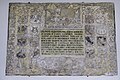 Eenum - kerk - epitaaf Reint Alberda.jpg 5,416 × 3,611; 12.19 MB
-
 Eenum - kerk - herenbank.jpg 3,648 × 2,736; 1.75 MB
-
 Eenum - kerk - herenbanken.jpg 3,312 × 2,298; 1.69 MB
-
 Eenum - kerk - orgel met interieur.jpg 6,000 × 4,000; 11.49 MB
-
 Eenum - kerk - preekstoel.jpg 2,562 × 3,414; 2.14 MB
-
 Eenum - kerk - vensters.jpg 2,736 × 3,648; 2.03 MB
-
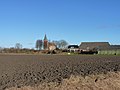 Eenum Kerk op Wierde.JPG 4,000 × 3,000; 6.49 MB
-

-

-
 Fries noordzijde achter orgel - Eenum - 20067619 - RCE.jpg 1,192 × 1,200; 324 KB
-
 Fries noordzijde bij orgel - Eenum - 20067618 - RCE.jpg 1,195 × 1,200; 312 KB
-
 Fries noordzijde in het midden - Eenum - 20067617 - RCE.jpg 1,192 × 1,200; 332 KB
-
 Fries westzijde bij orgel - Eenum - 20067629 - RCE.jpg 1,200 × 1,200; 355 KB
-
 Gepolychromeerde grafsteen - Eenum - 20067647 - RCE.jpg 1,200 × 1,200; 294 KB
-
 Gevonden grafsteen achter preekstoel - Eenum - 20067631 - RCE.jpg 1,188 × 1,200; 360 KB
-

-
 Interieur - Eenum - 20067639 - RCE.jpg 1,198 × 1,200; 192 KB
-
 Interieur naar de preekstoel - Eenum - 20067638 - RCE.jpg 1,200 × 1,200; 196 KB
-
 Interieur naar het oosten - Eenum - 20067604 - RCE.jpg 1,200 × 959; 162 KB
-
 Interieur naar het orgel - Eenum - 20067640 - RCE.jpg 1,189 × 1,200; 225 KB
-
 Interieur naar het westen - Eenum - 20067606 - RCE.jpg 1,200 × 956; 179 KB
-
 Interieur, gedenkplaat - Eenum - 20261618 - RCE.jpg 1,200 × 769; 203 KB
-
 Interieur, overzicht naar het westen met orgel - Eenum - 20261615 - RCE.jpg 1,200 × 742; 132 KB
-
 Interieur, overzicht preekstoel - Eenum - 20261617 - RCE.jpg 813 × 1,200; 131 KB
-
 Interieur, zuidmuur, schilderingen - Eenum - 20261616 - RCE.jpg 1,200 × 802; 124 KB
-
 Kerk Eenum, baksteen uit de 12e eeuw.jpg 528 × 960; 101 KB
-
 Kerk Eenum.jpg 2,000 × 2,000; 1.46 MB
-
 Kerk Eenum1.jpg 1,296 × 972; 1.19 MB
-
 Kerk Eenum2.jpg 1,296 × 972; 597 KB
-
 Kerk Eenum3.jpg 972 × 1,296; 534 KB
-
 Kerk van Eenum - glas in loodraam.jpg 761 × 611; 224 KB
-
 Koperen kroon - Eenum - 20067597 - RCE.jpg 856 × 1,200; 114 KB
-
 Nieuwe fundering toren - Eenum - 20067632 - RCE.jpg 1,197 × 1,200; 446 KB
-
 Noord-gevel - Eenum - 20067602 - RCE.jpg 1,200 × 954; 300 KB
-
 Noord-gevel, detail - Eenum - 20067603 - RCE.jpg 947 × 1,200; 383 KB
-
 Noord-oost gevel - Eenum - 20067637 - RCE.jpg 1,200 × 965; 274 KB
-
 Noordgevel toren - Eenum - 20067636 - RCE.jpg 961 × 1,200; 291 KB
-
 Noordwand - Eenum - 20067612 - RCE.jpg 1,200 × 1,196; 271 KB
-
 Noordwand - Eenum - 20067613 - RCE.jpg 1,195 × 1,200; 311 KB
-
 Overzicht noordzijde - Eenum - 20067609 - RCE.jpg 1,200 × 1,200; 426 KB
-
 Overzicht zuidwand - Eenum - 20067621 - RCE.jpg 1,190 × 1,200; 335 KB
-
 Preekstoel - Eenum - 20067594 - RCE.jpg 847 × 1,200; 151 KB
-
 Preekstoel - Eenum - 20067605 - RCE.jpg 954 × 1,200; 181 KB
-
 Preekstoel - Eenum - 20067641 - RCE.jpg 1,191 × 1,200; 171 KB
-
 Restauratie schildering noordwand ter hoogte van preekstoel - Eenum - 20067614 - RCE.jpg 1,200 × 1,192; 352 KB
-
 Restauratie schildering zuidwand bij orgel - Eenum - 20067623 - RCE.jpg 1,197 × 1,200; 352 KB
-
 Restauratie schildering zuidzijde links van middenvenster - Eenum - 20067622 - RCE.jpg 1,192 × 1,200; 284 KB
-
 Scheur in zuidmuur - Eenum - 20067627 - RCE.jpg 1,190 × 1,200; 383 KB
-
 Schildering - Eenum - 20067643 - RCE.jpg 1,200 × 1,193; 205 KB
-
 Schildering - Eenum - 20067644 - RCE.jpg 1,195 × 1,200; 201 KB
-
 Schildering - Eenum - 20067645 - RCE.jpg 1,195 × 1,200; 230 KB
-
 Schildering - Eenum - 20067646 - RCE.jpg 1,193 × 1,200; 242 KB
-
 Tekening reproductie bodemonderzoek tekening - Eenum - 20067633 - RCE.jpg 1,200 × 949; 214 KB
-
 Tekst op zuidwand links van ingang - Eenum - 20067625 - RCE.jpg 1,200 × 1,199; 382 KB
-
 Tekstschildering noordzijde bij orgel - Eenum - 20067615 - RCE.jpg 1,195 × 1,200; 390 KB
-
 Toren - Eenum - 20067607 - RCE.jpg 1,200 × 805; 212 KB
-
 Toren - Eenum - 20067608 - RCE.jpg 1,200 × 803; 235 KB
-
 Toren - Eenum - 20358149 - RCE.jpg 1,200 × 800; 245 KB
-
 Vanuit het zuiden - Eenum - 20067598 - RCE.jpg 1,200 × 986; 264 KB
-
 Zilveren kan - Eenum - 20067596 - RCE.jpg 1,200 × 821; 176 KB
-
 Zuid-gevel - Eenum - 20067601 - RCE.jpg 1,200 × 941; 318 KB
-
 Zuid-oost gevel - Eenum - 20067649 - RCE.jpg 1,200 × 956; 422 KB
-
 Zuid-oost zijde - Eenum - 20067599 - RCE.jpg 1,200 × 955; 404 KB
-
 Zuid-zijde - Eenum - 20067600 - RCE.jpg 1,200 × 955; 400 KB
-
 Zuidgevel - Eenum - 20067634 - RCE.jpg 953 × 1,200; 347 KB
-
 Zuidgevel - Eenum - 20067635 - RCE.jpg 955 × 1,200; 331 KB
-
 Zuidgevel - Eenum - 20067648 - RCE.jpg 1,200 × 955; 465 KB
_fan%C3%BAt_it_noardw%C3%AAst.jpg)
_fan%C3%BAt_it_s%C3%BAdeasten.jpg)
,_hearebank_mei_fykwurk.jpg)
,_ynrjochting.jpg)
.jpg)


