Category:Kerkstraat 32, Arnhem
| Object location | | View all coordinates using: OpenStreetMap |
|---|
house in Arnhem, Netherlands  | |||||
| Upload media | |||||
| Instance of | |||||
|---|---|---|---|---|---|
| Location | Arnhem, Gelderland, Netherlands | ||||
| Street address |
| ||||
| Located on street | |||||
| Heritage designation |
| ||||
 | |||||
|
This is a category about rijksmonument number 8342
|
|
This is a category about rijksmonument number 8343
|
| Address |
|
Media in category "Kerkstraat 32, Arnhem"
The following 5 files are in this category, out of 5 total.
-
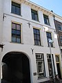
 Arnhem - Kerkstraat 32 poort.jpg 1,944 × 2,592; 886 KB
-
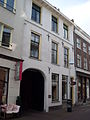
 Arnhem - Kerkstraat 32.jpg 1,944 × 2,592; 897 KB
-
 Kerkstraat 32.JPG 2,304 × 3,072; 1.69 MB
-
 Voorgevels - Arnhem - 20025448 - RCE.jpg 1,002 × 1,200; 205 KB
-
 Voorgevels - Arnhem - 20025449 - RCE.jpg 956 × 1,200; 224 KB


