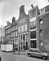
Category:Kerkstraat 322, Amsterdam
| Object location | | View all coordinates using: OpenStreetMap |
|---|
 | |||||
| Upload media | |||||
| Instance of | |||||
|---|---|---|---|---|---|
| Location | Amsterdam, North Holland, Netherlands | ||||
| Street address |
| ||||
| Located on street | |||||
| Heritage designation |
| ||||
 | |||||
|
This is a category about rijksmonument number 2938
|
| Address |
|
Media in category "Kerkstraat 322, Amsterdam"
The following 4 files are in this category, out of 4 total.
-
 Exterieur VOORGEVELS, OVERZICHT - Amsterdam - 20298747 - RCE.jpg 960 × 1,200; 282 KB
-
 Gevelsteen Kerkstraat 322.jpg 2,448 × 3,264; 984 KB
-
 Kerkstraat 322.jpg 3,264 × 2,448; 1.86 MB
-


