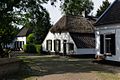
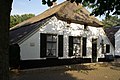
Category:Kerkstraat 5, Batenburg
| Object location | | View all coordinates using: OpenStreetMap |
|---|
farmhouse in Wijchen, Netherlands  | |||||
| Upload media | |||||
| Instance of | |||||
|---|---|---|---|---|---|
| Location | Batenburg, Gelderland, Netherlands | ||||
| Street address |
| ||||
| Located on street |
| ||||
| Heritage designation |
| ||||
 | |||||
|
This is a category about rijksmonument number 8710
|
| Address |
|
Media in category "Kerkstraat 5, Batenburg"
The following 9 files are in this category, out of 9 total.
-
 Batenburg Rijksmonument 8710 Kerkstraat 5.JPG 3,648 × 2,736; 3.63 MB
-
 Kerkstraat Batenburg.jpg 1,200 × 801; 528 KB
-
 Voor en rechter zijgevel - Batenburg - 20028492 - RCE.jpg 1,200 × 957; 283 KB
-
 Voor- en rechter zijgevel - Batenburg - 20028494 - RCE.jpg 1,200 × 960; 295 KB
-
 Voorgevel - Batenburg - 20028491 - RCE.jpg 1,200 × 957; 356 KB
-
 Voorgevel - Batenburg - 20028493 - RCE.jpg 1,200 × 948; 235 KB
-
 WLM - 23dingenvoormusea - kerkstraat, batenburg.jpg 1,200 × 798; 459 KB
-
 Woonhuizen - Batenburg - 20028490 - RCE.jpg 1,200 × 1,185; 409 KB
-
 Zijgevel - Batenburg - 20464325 - RCE.jpg 1,200 × 900; 158 KB


