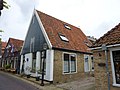
Category:Kerkstraat 9, Oosterend
| Object location | | View all coordinates using: OpenStreetMap |
|---|
building in Texel, Netherlands  | |||||
| Upload media | |||||
| Instance of | |||||
|---|---|---|---|---|---|
| Location | Oosterend, Texel, North Holland, Netherlands | ||||
| Street address |
| ||||
| Located on street |
| ||||
| Heritage designation |
| ||||
 | |||||
|
This is a category about rijksmonument number 35219
|
| Address |
|
Media in category "Kerkstraat 9, Oosterend"
The following 3 files are in this category, out of 3 total.
-
 Kerkstraat 9 - Oosterend - 20174498 - RCE.jpg 1,200 × 1,185; 221 KB
-
 Kerkstraat 9 en 11 - Oosterend - 20174499 - RCE.jpg 1,200 × 1,192; 239 KB
-
 Woonhuis Kerkstraat 9 - Oosterend.jpg 3,648 × 2,736; 4.54 MB

