Category:Kilpeck
village and civil parish in Herefordshire, UK Feb2006.jpg) | |||||
| Upload media | |||||
| Instance of | |||||
|---|---|---|---|---|---|
| Location | Herefordshire, West Midlands, England | ||||
| Said to be the same as | Kilpeck (Wikimedia duplicated page, civil parish) | ||||
 | |||||
Subcategories
This category has the following 7 subcategories, out of 7 total.
Media in category "Kilpeck"
The following 200 files are in this category, out of 367 total.
(previous page) (next page)-

-

-
 A465 and distant view - geograph.org.uk - 2774360.jpg 1,024 × 768; 397 KB
-
 A465 approaching B4348 junction - geograph.org.uk - 2954512.jpg 640 × 480; 69 KB
-
 A465 at Didley - geograph.org.uk - 2076107.jpg 3,072 × 2,304; 1.88 MB
-
 A465 at Pontrilas Sawmills - geograph.org.uk - 2953409.jpg 640 × 480; 44 KB
-
 A465 at Ravensiege Wood - geograph.org.uk - 4789895.jpg 1,600 × 901; 525 KB
-
 A465 near Grove Park - geograph.org.uk - 2953412.jpg 640 × 480; 51 KB
-
 A465 near Howton Farm - geograph.org.uk - 2953410.jpg 640 × 481; 75 KB
-
 A465 near Stock Farm - geograph.org.uk - 2954502.jpg 640 × 481; 35 KB
-
 A465 near Wormbridge - geograph.org.uk - 2078923.jpg 640 × 480; 98 KB
-
 A465 near Wormbridge - geograph.org.uk - 2953413.jpg 640 × 481; 41 KB
-
 A465 west of Didley - geograph.org.uk - 2954489.jpg 640 × 480; 42 KB
-
 A465, Wormbridge - geograph.org.uk - 4865895.jpg 800 × 652; 163 KB
-
 Access to poultry farm near Kilpeck - geograph.org.uk - 3425484.jpg 1,024 × 512; 76 KB
-
 Accommodation Crossing - geograph.org.uk - 3154267.jpg 640 × 427; 111 KB
-
 Across the valley of Marlas Brook - geograph.org.uk - 3749446.jpg 4,320 × 2,297; 1.24 MB
-
 Ancient church with modern guttering - geograph.org.uk - 5560183.jpg 1,600 × 900; 408 KB
-
 Ancient oak at Kilpeck church - geograph.org.uk - 5581206.jpg 3,323 × 2,209; 3.06 MB
-
 Approaching Orcop Hill - geograph.org.uk - 134220.jpg 640 × 426; 106 KB
-
 Arable and pastoral - geograph.org.uk - 4789880.jpg 1,600 × 901; 738 KB
-
 Arable fields at Kilpeck - geograph.org.uk - 3749124.jpg 4,320 × 2,160; 1.24 MB
-
 Arable land at Kilpeck - geograph.org.uk - 2186150.jpg 1,024 × 768; 150 KB
-
 Arable land near Howton - geograph.org.uk - 2078929.jpg 3,072 × 2,304; 2.35 MB
-
 Arable land near Kilpeck - geograph.org.uk - 2077429.jpg 3,072 × 2,304; 2.2 MB
-
 Arriva train Wales - geograph.org.uk - 3154224.jpg 640 × 427; 117 KB
-
 Avenue of oaks - geograph.org.uk - 4789889.jpg 1,600 × 901; 716 KB
-
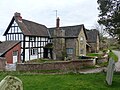
 Bakery Cottage, Kilpeck, Herefordshire - geograph.org.uk - 5597090.jpg 800 × 557; 127 KB
-
 Big Wood - geograph.org.uk - 2080257.jpg 640 × 480; 134 KB
-

-
 Blue barn - geograph.org.uk - 2772851.jpg 1,024 × 768; 486 KB
-
 Bridge near Kilpeck - geograph.org.uk - 1187580.jpg 640 × 425; 156 KB
-

-

-
 Bryngwyn Manor, aerial 2018 - geograph.org.uk - 5844607.jpg 800 × 533; 106 KB
-
 By the Hand of The Master - geograph.org.uk - 5580845.jpg 2,416 × 3,038; 2.47 MB
-
 Car heading for Kilkpeck - geograph.org.uk - 4637209.jpg 640 × 480; 181 KB
-
 Cattle feeder - geograph.org.uk - 2185051.jpg 1,024 × 768; 283 KB
-
 Cayo Farm, 2016 - geograph.org.uk - 4789884.jpg 1,600 × 901; 722 KB
-
 Church wall, Wormbridge - geograph.org.uk - 6081893.jpg 4,608 × 3,456; 2.05 MB
-
 Corn Field nr Didley - geograph.org.uk - 3114350.jpg 640 × 427; 75 KB
-
 Cottages opposite Kilpeck church - geograph.org.uk - 2185031.jpg 1,024 × 768; 242 KB
-
 Country around Kilpeck - geograph.org.uk - 2185047.jpg 1,024 × 768; 261 KB
-
 Cutting for the road to Gallows Knapp - geograph.org.uk - 3425648.jpg 1,024 × 765; 316 KB
-

-
 Daffodils in the sunshine - geograph.org.uk - 6081571.jpg 1,600 × 1,197; 1.18 MB
-
 Dead oak in pasture - geograph.org.uk - 3095166.jpg 1,200 × 676; 414 KB
-
 Dead tree - geograph.org.uk - 3255664.jpg 1,024 × 680; 163 KB
-
 Didley, aerial 2018 - geograph.org.uk - 5844015.jpg 533 × 800; 111 KB
-
 Ditch at St Devereux - geograph.org.uk - 2078695.jpg 640 × 480; 101 KB
-
 Drive to Cayo Farm - geograph.org.uk - 5030183.jpg 640 × 480; 64 KB
-

-
 Entrance to Dippersmoor Farm - geograph.org.uk - 1535201.jpg 640 × 481; 125 KB
-

-
 Farm headland track - geograph.org.uk - 1812769.jpg 640 × 426; 100 KB
-
 Farm yard opposite Kilpeck Church - geograph.org.uk - 2475534.jpg 640 × 480; 78 KB
-
 Farmland above Marlas Brook - geograph.org.uk - 3256910.jpg 1,024 × 680; 247 KB
-
 Farmland at Kilpeck - geograph.org.uk - 3256368.jpg 1,024 × 680; 201 KB
-
 Farmland at New House Farm - geograph.org.uk - 3256392.jpg 1,024 × 680; 257 KB
-
 Farmland at St Devereux - geograph.org.uk - 2078699.jpg 640 × 480; 91 KB
-
 Farmland east of Kilpeck, aerial 2018 - geograph.org.uk - 5844034.jpg 660 × 1,024; 111 KB
-
 Farmland near Kilpeck - geograph.org.uk - 1187602.jpg 640 × 425; 79 KB
-
 Farmland near Kilpeck - geograph.org.uk - 3322600.jpg 640 × 480; 47 KB
-

-

-
 Field north east of Kilpeck Church - geograph.org.uk - 2475545.jpg 640 × 480; 67 KB
-
 Field of fruit trees - geograph.org.uk - 2077442.jpg 3,072 × 2,304; 2.27 MB
-
 Field of potatoes - geograph.org.uk - 3258334.jpg 1,024 × 680; 290 KB
-
 Fields near Knolton Farm - geograph.org.uk - 2186143.jpg 1,024 × 768; 252 KB
-
 Fields near Marlas - geograph.org.uk - 4637215.jpg 640 × 480; 117 KB
-
 Footpath across pasture - geograph.org.uk - 3095175.jpg 1,200 × 676; 392 KB
-
 Footpath at Gallows Knapp - geograph.org.uk - 2077439.jpg 3,072 × 2,304; 3.15 MB
-
 Footpath Railway Crossing - geograph.org.uk - 2389476.jpg 600 × 800; 107 KB
-
 Forge Filling Station - geograph.org.uk - 2078706.jpg 3,072 × 2,304; 1.79 MB
-
 Former station, Kilpeck - geograph.org.uk - 2077424.jpg 640 × 480; 109 KB
-
 Former Vicarage, Kilpeck - geograph.org.uk - 2077432.jpg 640 × 480; 90 KB
-
 Fruit trees growing in a field - geograph.org.uk - 4634254.jpg 640 × 480; 98 KB
-
 Galanthus Gallery and Cafe - geograph.org.uk - 2078914.jpg 3,072 × 2,304; 1.97 MB
-
 Galanthus nivalis, Common Snowdrop - geograph.org.uk - 6058885.jpg 1,600 × 1,201; 669 KB
-

-
 Garage sign, Forge Filling Station - geograph.org.uk - 2078909.jpg 2,304 × 3,072; 1.4 MB
-
 Goughs Bridge - geograph.org.uk - 3154239.jpg 427 × 640; 141 KB
-

-
 Grassland at Knolton Farm - geograph.org.uk - 928142.jpg 640 × 480; 66 KB
-
 Great Oak House, Kilpeck, Herefordshire - geograph.org.uk - 5597137.jpg 800 × 716; 131 KB
-
 Helleborus orientalis - geograph.org.uk - 6058886.jpg 1,600 × 1,201; 1.21 MB
-
 Here come the boys - geograph.org.uk - 2772800.jpg 1,024 × 770; 718 KB
-
 Herefordshire farm land - geograph.org.uk - 2772811.jpg 1,024 × 768; 502 KB
-
 House opposite Kilpeck church, Herefordshire - geograph.org.uk - 4958665.jpg 1,600 × 1,200; 533 KB
-
 Houses at Crizeley - geograph.org.uk - 2077416.jpg 3,072 × 2,304; 1.96 MB
-
 Houses opposite Kilpeck Church - geograph.org.uk - 2475542.jpg 640 × 480; 105 KB
-

-

-
 K6 telephone box in Kilpeck.jpg 4,000 × 3,000; 5.32 MB
-
 Kilpeck Castle - geograph.org.uk - 5580313.jpg 3,323 × 2,209; 3.19 MB
-
 Kilpeck Castle - geograph.org.uk - 5580458.jpg 3,323 × 2,209; 2.4 MB
-
 Kilpeck Castle - geograph.org.uk - 5580548.jpg 3,323 × 2,209; 2.34 MB
-
 Kilpeck Castle and Church, aerial 2018 - geograph.org.uk - 5844151.jpg 1,024 × 683; 188 KB
-
 Kilpeck Castle earthworks - geograph.org.uk - 5268796.jpg 1,000 × 664; 630 KB
-
 Kilpeck church from a shady Oak tree - geograph.org.uk - 5805373.jpg 3,562 × 2,378; 7.51 MB
-
 Kilpeck church, Herefordshire - geograph.org.uk - 4958653.jpg 1,600 × 1,200; 451 KB
-
 Kilpeck Court Farm 01.jpg 4,000 × 3,000; 4.75 MB
-
 Kilpeck Court Farm 02.jpg 4,000 × 3,000; 4.85 MB
-
 Kilpeck Court Farmhouse - geograph.org.uk - 5268794.jpg 1,000 × 664; 769 KB
-
 Kilpeck landscape - geograph.org.uk - 3256386.jpg 1,024 × 680; 293 KB
-
 Kilpeck, aerial 2018 (1) - geograph.org.uk - 5844140.jpg 1,024 × 683; 137 KB
-
 Kilpeck, aerial 2018 - geograph.org.uk - 5844146.jpg 1,024 × 682; 142 KB
-

-

-

-
-

-

-
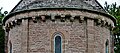
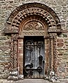
 Kilpeck, The church of St. Mary and St. David - geograph.org.uk - 4625880.jpg 4,510 × 2,591; 7.12 MB
-
 Kilpeck, The church of St. Mary and St. David - geograph.org.uk - 4625883.jpg 4,551 × 2,460; 6.85 MB
-
 Kilpeck, The church of St. Mary and St. David - geograph.org.uk - 4661716.jpg 3,679 × 2,456; 5.47 MB
-
 Kilpeck, The church of St. Mary and St. David - geograph.org.uk - 4661725.jpg 3,678 × 2,456; 6.11 MB
-

-

-

-

-

-

-

-
-

-

-

-

-

-

-

-

-

-

-

-

-

-
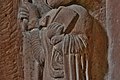
 Kilpeck, The church of St. Mary and St. David, Ram corbel - geograph.org.uk - 4662624.jpg 3,700 × 3,673; 7.29 MB
-

-

-

-

-

-

-

-
-

-

-

-

-

-

-

-
-

-
 Kilpeck, The church of St. Mary and St. David, West aspect - geograph.org.uk - 4661732.jpg 1,769 × 1,071; 1.52 MB
-
 Kilpeck, The church of St. Mary and St. David, West aspect - geograph.org.uk - 4661736.jpg 4,341 × 2,717; 6.63 MB
-

-
 Kilpeck, view from the churchyard - geograph.org.uk - 2782341.jpg 1,600 × 1,066; 321 KB
-
 Kilpeck, view from the churchyard - geograph.org.uk - 2782343.jpg 1,600 × 1,066; 322 KB
-
 Lane to Grafton Oak - geograph.org.uk - 3749440.jpg 3,240 × 4,320; 1.93 MB
-
 Lane to Kilpeck - geograph.org.uk - 2773186.jpg 1,024 × 768; 528 KB
-
 Lane, St Devereux - geograph.org.uk - 5269363.jpg 1,000 × 664; 854 KB
-
 Lay-by near Didley - geograph.org.uk - 2186192.jpg 1,024 × 768; 211 KB
-
 Lay-by on the A465 - geograph.org.uk - 2773194.jpg 640 × 480; 91 KB
-
 Lay-by on the A465 near Howton - geograph.org.uk - 2078937.jpg 3,072 × 2,304; 1.94 MB
-
 Layby on the A465 nr Didley - geograph.org.uk - 3114355.jpg 640 × 427; 98 KB
-
 Listed barn at Kilpeck Court Farm 02.jpg 4,000 × 3,000; 4.66 MB
-
 Listed barn at Kilpeck Court Farm.jpg 4,000 × 3,000; 1.08 MB
-
 Listed barns at Priory Farmhouse, Kilpeck 01.jpg 4,000 × 3,000; 4.79 MB
-
 Listed barns at Priory Farmhouse, Kilpeck 02.jpg 4,000 × 3,000; 4.89 MB
-
 Lodge on the Whitfield Estate - geograph.org.uk - 2078700.jpg 640 × 480; 98 KB
-
 Machinery at Tophill farm - geograph.org.uk - 4637219.jpg 640 × 480; 152 KB
-
 Marlas Mill viewed from the south - geograph.org.uk - 3258315.jpg 1,024 × 680; 219 KB
-
 Marlas, 1 - geograph.org.uk - 5999922.jpg 1,600 × 903; 778 KB
-
 Marlas, 2 - geograph.org.uk - 5999936.jpg 1,600 × 901; 764 KB
-
 Marlas, 3 - geograph.org.uk - 5999941.jpg 1,600 × 900; 770 KB
-
 Marlas, 4 - geograph.org.uk - 6006002.jpg 1,600 × 1,200; 751 KB
-
 Mature Oak at Kilpeck - geograph.org.uk - 5581175.jpg 3,323 × 2,209; 1.83 MB
-
 Medieval village site at Kilpeck - geograph.org.uk - 3749135.jpg 4,320 × 3,240; 2.09 MB
-
 Merryvale Farm - geograph.org.uk - 3751375.jpg 4,320 × 3,240; 5.72 MB
-
 Milestone at Didley - geograph.org.uk - 2077412.jpg 2,304 × 3,072; 2.8 MB
-
 Minor country road - geograph.org.uk - 6058869.jpg 1,600 × 900; 313 KB
-
 Misty autumn dawn over Kilpeck - geograph.org.uk - 3188429.jpg 640 × 480; 55 KB
-
 Misty Herefordshire autumn dawn - geograph.org.uk - 3188441.jpg 640 × 480; 30 KB
-
 Muddy field entrance - geograph.org.uk - 4637212.jpg 640 × 480; 158 KB
-
 Muddy field near Willox Bridge Farm - geograph.org.uk - 6116967.jpg 800 × 525; 68 KB
-

-
 Old oak tree - geograph.org.uk - 1812766.jpg 426 × 640; 94 KB
-
 Old postbox on the railway bridge at Kilpeck - geograph.org.uk - 4279010.jpg 2,592 × 3,872; 3.59 MB
-
 Old railway station at Kilpeck - geograph.org.uk - 4278999.jpg 3,872 × 2,592; 2.66 MB
-
 Pasture land by the Marches Railway - geograph.org.uk - 4789878.jpg 1,600 × 901; 745 KB
-
 Ploughed field and Mill Wood - geograph.org.uk - 3256363.jpg 1,024 × 680; 259 KB
-
 Pontrilas Sawmill - geograph.org.uk - 2078951.jpg 3,072 × 2,304; 2.02 MB
-
 Pontrilas Sawmills - geograph.org.uk - 2078943.jpg 3,072 × 2,304; 1.86 MB
-
 Pontrilas Sawmills - geograph.org.uk - 2773200.jpg 1,024 × 580; 308 KB
-
 Pontrilas Sawmills from the church - geograph.org.uk - 3930435.jpg 4,752 × 3,168; 2.75 MB
-

-
 Potato field west of Old Mill Farm - geograph.org.uk - 4504477.jpg 800 × 450; 230 KB


_-_geograph.org.uk_-_5844140.jpg)


