Category:Kimbolton, Herefordshire
village and parish in Herefordshire, England  | |||||
| Upload media | |||||
| Instance of | |||||
|---|---|---|---|---|---|
| Location | Herefordshire, West Midlands, England | ||||
 | |||||
Cymraeg: Pentref a phlwyf yn Swydd Henffordd yw Kimbolton sydd oddeutu i'r gogledd o Henffordd, Gorllewin Canolbarth Lloegr, Lloegr. Saif y pentre ar yr A49 road. Yma hefyd y saif Eglwys Sant Iago (The Church of St James) eglwys a adeiladwyd yn y 13eg ganrif, gyda dwy ffenestr Normanaidd yn y gangell. Roedd gan y plwyf boblogaeth o 434 yn 2010, increasing to 472 at the 2011 Census. (→Kimbolton, Swydd Henffordd)
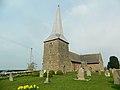
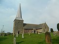
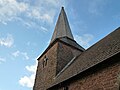
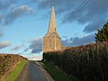
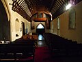
English: Kimbolton is a village and parish in Herefordshire, England, north of Hereford. The village is next to the A49 road. The church is dedicated to St James, has 13th-century features and has two Norman windows in the chancel. The spire is shingled. (→Kimbolton, Herefordshire)
Nederlands: Kimbolton is een plaats en civil parish in het Engelse graafschap Herefordshire. In 2001 telde het civil parish 472 inwoners. (→Kimbolton (Herefordshire))
Polski: Kimbolton – wieś i civil parish w Anglii, w hrabstwie Herefordshire. W 2011 civil parish liczyła 472 mieszkańców. (→Kimbolton (Herefordshire))

Subcategories
This category has the following 4 subcategories, out of 4 total.
H
S
Media in category "Kimbolton, Herefordshire"
The following 200 files are in this category, out of 242 total.
(previous page) (next page)-
 "Coming Soon Oakwood" Sign at Kimbolton - geograph.org.uk - 6001471.jpg 2,048 × 1,360; 1.26 MB
-

-

-

-

-
 A4112 approaching Kimbolton - geograph.org.uk - 1052671.jpg 640 × 480; 90 KB
-
 A4112 at Hopnall Way east of Kimbolton - geograph.org.uk - 5166823.jpg 1,600 × 1,200; 761 KB
-
 A4112 in woodland at Stockton Cross - geograph.org.uk - 5166807.jpg 1,600 × 1,200; 807 KB
-
 A49 Ludlow Road looking north - geograph.org.uk - 2956754.jpg 640 × 480; 36 KB
-
 A49 north of Hay Lane Farm - geograph.org.uk - 3734018.jpg 3,669 × 2,495; 1.22 MB
-
 AA Sign at Kimbolton - geograph.org.uk - 6001457.jpg 3,648 × 2,736; 4.8 MB
-
-
 An orchard at The Hundred - geograph.org.uk - 5412403.jpg 1,024 × 768; 394 KB
-
 Arable field near Hamnish Clifford - geograph.org.uk - 5206532.jpg 800 × 600; 161 KB
-
 Arriva Trains Wales train - geograph.org.uk - 5617825.jpg 1,024 × 768; 192 KB
-
 Autumn hillside near Stockton - geograph.org.uk - 1052688.jpg 640 × 480; 106 KB
-
 Bach - geograph.org.uk - 4213771.jpg 800 × 600; 402 KB
-
 Barn at Little Bury - geograph.org.uk - 4877048.jpg 3,321 × 2,122; 1.08 MB
-
 Barn NE of Leominster - geograph.org.uk - 3801507.jpg 800 × 605; 98 KB
-
 Black and White - geograph.org.uk - 146794.jpg 640 × 480; 106 KB
-
 BP garage at Leominster - geograph.org.uk - 4329192.jpg 3,872 × 2,592; 3.46 MB
-

-
-
 Brightwell's on the Leominster Bypass - geograph.org.uk - 6155065.jpg 1,872 × 1,204; 934 KB
-
-
 Cheaton Brook, Leominster - geograph.org.uk - 3801447.jpg 800 × 539; 126 KB
-
 Chevrons on a roundabout - geograph.org.uk - 2284818.jpg 640 × 430; 53 KB
-
 Churchyard at St. James' Church (Kimbolton) - geograph.org.uk - 6001334.jpg 2,048 × 1,360; 1.39 MB
-
 Churchyard, Kimbolton - geograph.org.uk - 6109009.jpg 800 × 600; 90 KB
-
 Cluns, Stockton - geograph.org.uk - 4414935.jpg 800 × 533; 388 KB
-
 Cogwell Brook (Kimbolton) - geograph.org.uk - 6001466.jpg 3,648 × 2,736; 4.84 MB
-

-
 Converted chapel - geograph.org.uk - 3205664.jpg 640 × 480; 58 KB
-
 Cottage in farmland - geograph.org.uk - 5617780.jpg 1,024 × 768; 265 KB
-
 Country road at Kimbolton - geograph.org.uk - 5412412.jpg 1,024 × 768; 390 KB
-
 Country road at Kimbolton - geograph.org.uk - 5412445.jpg 1,024 × 768; 249 KB
-
 Country road near Brock Hall - geograph.org.uk - 5206585.jpg 800 × 600; 186 KB
-
 Country road near Lower Kimbolton Farm - geograph.org.uk - 5412409.jpg 800 × 600; 181 KB
-

-
 Distances from Leominster - geograph.org.uk - 3801484.jpg 800 × 609; 92 KB
-
 Dried up course of the Leominster Canal - geograph.org.uk - 5617733.jpg 1,024 × 768; 419 KB
-
 Entrance to St. James' Church (Bell Tower ^ Kimbolton) - geograph.org.uk - 6001322.jpg 3,648 × 2,736; 2.23 MB
-
 Farm track, Far Heath,Kimbolton - geograph.org.uk - 146803.jpg 640 × 480; 81 KB
-
 Farmland at Grantsfield - geograph.org.uk - 5207706.jpg 800 × 600; 155 KB
-
 Farmland at Stockton - geograph.org.uk - 5207720.jpg 1,024 × 768; 283 KB
-
 Farmland in the Lugg valley - geograph.org.uk - 5617740.jpg 1,024 × 768; 268 KB
-
 Farmland near Grantsfield - geograph.org.uk - 5207535.jpg 800 × 600; 152 KB
-
 Farmland near New House - geograph.org.uk - 5412441.jpg 1,024 × 768; 267 KB
-
 Farmland opposite Olden Farm - geograph.org.uk - 5413480.jpg 1,024 × 768; 242 KB
-
 Farmland to the north of Leominster - geograph.org.uk - 5207763.jpg 1,024 × 768; 263 KB
-
 Field at Kimbolton - geograph.org.uk - 5412438.jpg 1,024 × 768; 311 KB
-

-
 Field of winter cereal near Kimbolton - geograph.org.uk - 5207510.jpg 1,024 × 768; 262 KB
-
 Fields Near Bache - geograph.org.uk - 1460682.jpg 640 × 480; 220 KB
-
 Fields near Kimbolton - geograph.org.uk - 1052677.jpg 640 × 480; 95 KB
-
 Footpath and track - geograph.org.uk - 5617743.jpg 1,024 × 768; 314 KB
-

-
 Footpath beside the old Leominster Canal - geograph.org.uk - 5617791.jpg 800 × 600; 226 KB
-
 Footpath beside the old Leominster Canal - geograph.org.uk - 5617798.jpg 1,024 × 768; 403 KB
-
 Ford at Lower Bach - geograph.org.uk - 4294386.jpg 3,872 × 2,592; 4.91 MB
-
 Fuel Station and Roundabout - Leominster - geograph.org.uk - 4877044.jpg 3,145 × 2,228; 947 KB
-
 Gate into an orchard - geograph.org.uk - 5412396.jpg 1,024 × 768; 350 KB
-
 Gated road, Whyle - geograph.org.uk - 4223107.jpg 800 × 600; 440 KB
-
 Gothic mansion near Eaton Hill - geograph.org.uk - 2493967.jpg 640 × 480; 123 KB
-
 Grazing land near Stockton - geograph.org.uk - 1052708.jpg 640 × 480; 92 KB
-
 Green lane, Bache - geograph.org.uk - 4414956.jpg 800 × 533; 495 KB
-
 Hamnish Clifford church - geograph.org.uk - 5207494.jpg 1,024 × 768; 221 KB
-
 Hamnish Clifford village hall - geograph.org.uk - 5207500.jpg 800 × 600; 119 KB
-
 Hay Lane, Leominster - geograph.org.uk - 3801407.jpg 785 × 800; 217 KB
-
 Hedgerow oak trees - geograph.org.uk - 5207531.jpg 1,024 × 768; 256 KB
-
 Hundred Lane - geograph.org.uk - 4213728.jpg 800 × 600; 514 KB
-

-
 Junction, Hundred Lane - geograph.org.uk - 4789870.jpg 640 × 480; 63 KB
-
 Dovecote, Upper Bache, Kimbolton - geograph.org.uk - 131135.jpg 640 × 427; 127 KB
-
 Kimbolton St James primary school - geograph.org.uk - 5166818.jpg 1,600 × 1,200; 700 KB
-
 Kimbolton Village Hall - geograph.org.uk - 5996495.jpg 3,648 × 2,736; 3.95 MB
-
 Lane by Kimbolton - geograph.org.uk - 6001421.jpg 3,648 × 2,736; 4.09 MB
-
 Lane by Kimbolton - geograph.org.uk - 6001467.jpg 3,648 × 2,736; 4.96 MB
-
 Lane From Cog Hall To Kimbolton - geograph.org.uk - 1460789.jpg 640 × 480; 288 KB
-
 Lane junction near Stanley Bank - geograph.org.uk - 1052702.jpg 640 × 480; 82 KB
-
 Lane Near Bache - geograph.org.uk - 1460687.jpg 640 × 480; 204 KB
-
 Lane Near Cog Hall - geograph.org.uk - 1460787.jpg 640 × 480; 255 KB
-
 Lane to Leominster at Brock Hall - geograph.org.uk - 1052754.jpg 480 × 640; 94 KB
-
 Lane To Lever Hill - geograph.org.uk - 1460691.jpg 640 × 480; 205 KB
-
 Lane To Lower Bache - geograph.org.uk - 1460690.jpg 640 × 480; 162 KB
-
 Lane up Stanley Bank - geograph.org.uk - 1052698.jpg 640 × 480; 73 KB
-
 Lane, Bache - geograph.org.uk - 4414965.jpg 800 × 533; 407 KB
-
 Lane,Olden - geograph.org.uk - 4213767.jpg 800 × 600; 520 KB
-

-
 Leominster Priory, St Peter ^ St Paul's Church - geograph.org.uk - 6220650.jpg 4,096 × 2,304; 4.18 MB
-
 Leominster Wharf House - geograph.org.uk - 2325648.jpg 4,000 × 3,000; 2.14 MB
-
 Little Britain (Kimbolton) - geograph.org.uk - 6001329.jpg 3,648 × 2,736; 3.91 MB
-
 Lugg Valley flatlands - geograph.org.uk - 1052623.jpg 640 × 480; 85 KB
-

-
 Meeting of the lanes, Stockton - geograph.org.uk - 1052694.jpg 640 × 480; 134 KB
-
 Minnalls Farm (Kimbolton) - geograph.org.uk - 5996507.jpg 3,648 × 2,736; 4.64 MB
-
 New Housing Development (Kimbolton) - geograph.org.uk - 6001472.jpg 2,048 × 1,360; 1.39 MB
-
 Oak trees - geograph.org.uk - 5207702.jpg 800 × 600; 121 KB
-

-
 Orchard, Rowley - geograph.org.uk - 3275785.jpg 640 × 480; 310 KB
-
 Orchard, Stockton Cross - geograph.org.uk - 4414875.jpg 800 × 533; 469 KB
-
 Ordnance Survey 1GL Bolt - geograph.org.uk - 5312211.jpg 640 × 362; 82 KB
-
 Pateshall (Kimbolton) - geograph.org.uk - 6001437.jpg 3,648 × 2,736; 4.8 MB
-

-
 Poppies inside St. James' Church (Nave ^ Kimbolton) - geograph.org.uk - 6000946.jpg 3,648 × 2,736; 2.67 MB
-

-
 Primitive Methodist Chapel (Kimbolton) - geograph.org.uk - 6001468.jpg 3,648 × 2,736; 4.35 MB
-
 Raddle Bank - geograph.org.uk - 1566971.jpg 640 × 480; 178 KB
-
 Rainbow over Stockton Cross - geograph.org.uk - 2125332.jpg 640 × 480; 208 KB
-
 Reduce speed now near Leominster - geograph.org.uk - 3801499.jpg 800 × 616; 105 KB
-
 Ridgemoor Bridge, Leominster - geograph.org.uk - 3681950.jpg 800 × 633; 163 KB
-

-
 Road passing Downs Villa Farm - geograph.org.uk - 5207516.jpg 800 × 600; 174 KB
-
 Road sign on the A49 - geograph.org.uk - 2284810.jpg 640 × 430; 37 KB
-
 Road, Bache - geograph.org.uk - 4414950.jpg 800 × 533; 460 KB
-
 Roadside cow parsley - geograph.org.uk - 5413488.jpg 1,024 × 768; 237 KB
-
 Root crop, Kimbolton - geograph.org.uk - 1424480.jpg 640 × 480; 84 KB
-
 Shadow of St. James' Church (Kimbolton) - geograph.org.uk - 6001434.jpg 3,648 × 2,736; 4.64 MB
-
 Shadows on a lane at Kimbolton - geograph.org.uk - 6001446.jpg 3,648 × 2,736; 4.89 MB
-
 Shed in the corner of a field - geograph.org.uk - 5617748.jpg 1,024 × 768; 278 KB
-
 Sheep by St. James' Church (Kimbolton) - geograph.org.uk - 5996629.jpg 1,920 × 1,080; 1.05 MB
-
 Sheep by St. James' Church (Kimbolton) - geograph.org.uk - 5997428.jpg 1,920 × 1,080; 1.01 MB
-
 Sheep by St. James' Church (Kimbolton) - geograph.org.uk - 5997430.jpg 1,920 × 1,080; 778 KB
-
 Sheep by St. James' Church (Kimbolton) - geograph.org.uk - 5997438.jpg 1,920 × 1,080; 1,022 KB
-
 Sheep by St. James' Church (Kimbolton) - geograph.org.uk - 5997445.jpg 1,920 × 1,080; 1,021 KB
-
 Sheep by St. James' Church (Kimbolton) - geograph.org.uk - 5997462.jpg 2,048 × 1,360; 1.3 MB
-
 Sheep by St. James' Church (Kimbolton) - geograph.org.uk - 5997493.jpg 2,048 × 1,360; 1.14 MB
-
 Sheep by St. James' Church (Kimbolton) - geograph.org.uk - 5997505.jpg 2,048 × 1,360; 1.36 MB
-
 Sheep by St. James' Church (Kimbolton) - geograph.org.uk - 5997507.jpg 2,048 × 1,360; 1.34 MB
-
 Sheep by St. James' Church (Kimbolton) - geograph.org.uk - 5997508.jpg 2,048 × 1,360; 1.36 MB
-
 Sheep by St. James' Church (Kimbolton) - geograph.org.uk - 5997510.jpg 2,048 × 1,360; 1.35 MB
-
 Sheep by St. James' Church (Kimbolton) - geograph.org.uk - 5997524.jpg 1,920 × 1,080; 1.02 MB
-
 Sheep by St. James' Church (Kimbolton) - geograph.org.uk - 6001326.jpg 3,648 × 2,736; 4.57 MB
-
 Sheep grazing in a field - geograph.org.uk - 5207730.jpg 800 × 600; 150 KB
-
 Sheep, The Hundred - geograph.org.uk - 4663499.jpg 800 × 600; 466 KB
-
 Sheep, Whyle - geograph.org.uk - 4223111.jpg 800 × 600; 492 KB
-
 Spire at St. James' Church (Bell Tower ^ Kimbolton) - geograph.org.uk - 5997528.jpg 3,648 × 2,736; 3.77 MB
-
 Squirrel at Kimbolton - geograph.org.uk - 5996577.jpg 4,096 × 3,072; 4.54 MB
-
 St Dubricius, Hamnish Clifford - geograph.org.uk - 4001993.jpg 3,660 × 2,533; 2.52 MB
-
 St Dubricius, Hamnish Clifford - geograph.org.uk - 4002009.jpg 5,114 × 3,400; 3.46 MB
-
 St Dubricius, Hamnish Clifford - geograph.org.uk - 4002021.jpg 4,710 × 3,131; 3.95 MB
-
 St James Church, Kimbolton - geograph.org.uk - 5375762.jpg 2,150 × 1,435; 896 KB
-
 St James's Church ^ churchyard, Kimbolton - geograph.org.uk - 3921665.jpg 4,320 × 3,240; 2.62 MB
-
 St James's Church, Kimbolton - geograph.org.uk - 3921653.jpg 4,320 × 3,240; 2.87 MB
-
 St James's Church, Kimbolton - geograph.org.uk - 3921655.jpg 4,320 × 3,240; 2.89 MB
-
 St James's Church, Kimbolton - geograph.org.uk - 3921658.jpg 4,320 × 3,240; 2.78 MB
-
 St James, Kimbolton - geograph.org.uk - 3058828.jpg 3,351 × 2,364; 2.77 MB
-
 St James, Kimbolton - geograph.org.uk - 3058870.jpg 3,333 × 2,419; 2.1 MB
-
 St James, Kimbolton - geograph.org.uk - 3058918.jpg 3,242 × 2,355; 1.71 MB
-
 St. James Church of England Primary School (Kimbolton) - geograph.org.uk - 5996529.jpg 3,648 × 2,736; 4.37 MB
-
 St. James Church of England Primary School (Kimbolton) - geograph.org.uk - 5996558.jpg 3,648 × 2,736; 4.47 MB
-
 St. James' Church (Altar ^ Kimbolton) - geograph.org.uk - 6001314.jpg 3,648 × 2,736; 1.48 MB
-
 St. James' Church (Bell Tower ^ Kimbolton) - geograph.org.uk - 5999668.jpg 2,736 × 3,648; 4.34 MB
-
 St. James' Church (Bell Tower ^ Kimbolton) - geograph.org.uk - 5999676.jpg 3,648 × 2,736; 4.7 MB
-
 St. James' Church (Bell Tower ^ Kimbolton) - geograph.org.uk - 5999679.jpg 3,648 × 2,736; 3.82 MB
-
 St. James' Church (Bell Tower ^ Kimbolton) - geograph.org.uk - 6001431.jpg 3,648 × 2,736; 3.28 MB
-
 St. James' Church (Bell Tower ^ Kimbolton) - geograph.org.uk - 6001440.jpg 2,736 × 3,648; 4.75 MB
-
 St. James' Church (Bell Tower ^ Kimbolton) - geograph.org.uk - 6001447.jpg 3,648 × 2,736; 4.1 MB
-
 St. James' Church (Chancel ^ Kimbolton) - geograph.org.uk - 6000958.jpg 3,648 × 2,736; 2.07 MB
-
 St. James' Church (Font ^ Kimbolton) - geograph.org.uk - 5999682.jpg 3,648 × 2,736; 2.54 MB
-
 St. James' Church (Kimbolton) - geograph.org.uk - 5996553.jpg 3,648 × 2,736; 4.88 MB
-
 St. James' Church (Kimbolton) - geograph.org.uk - 5996606.jpg 3,648 × 2,736; 4.17 MB
-
 St. James' Church (Kimbolton) - geograph.org.uk - 5996608.jpg 1,920 × 1,080; 1.03 MB
-
 St. James' Church (Kimbolton) - geograph.org.uk - 5997523.jpg 2,048 × 1,360; 1.35 MB
-
 St. James' Church (Kimbolton) - geograph.org.uk - 5997527.jpg 3,648 × 2,736; 4.05 MB
-
 St. James' Church (Kimbolton) - geograph.org.uk - 6001325.jpg 1,920 × 1,080; 655 KB
-
 St. James' Church (Kimbolton) - geograph.org.uk - 6001331.jpg 3,648 × 2,736; 3.96 MB
-
 St. James' Church (Kimbolton) - geograph.org.uk - 6001350.jpg 2,048 × 1,360; 1.31 MB
-
 St. James' Church (Kimbolton) - geograph.org.uk - 6001417.jpg 3,648 × 2,736; 3.55 MB
-
 St. James' Church (Kimbolton) - geograph.org.uk - 6001423.jpg 3,648 × 2,736; 3.25 MB
-
 St. James' Church (Kimbolton) - geograph.org.uk - 6001454.jpg 3,648 × 2,736; 4.23 MB
-
 St. James' Church (Nave ^ Kimbolton) - geograph.org.uk - 5999681.jpg 3,648 × 2,736; 2.51 MB
-
 St. James' Church (Nave ^ Kimbolton) - geograph.org.uk - 6001321.jpg 3,648 × 2,736; 2.25 MB
-
 St. James' Church (Organ ^ Kimbolton) - geograph.org.uk - 5999683.jpg 3,648 × 2,736; 2.46 MB
-
 St. James' Church (Organ ^ Kimbolton) - geograph.org.uk - 6001300.jpg 3,648 × 2,736; 1.52 MB
-
 St. James' Church (Porch ^ Kimbolton) - geograph.org.uk - 5999678.jpg 3,648 × 2,736; 4.83 MB
-
 St. James' Church (Pulpit ^ Kimbolton) - geograph.org.uk - 6001022.jpg 3,648 × 2,736; 1.85 MB
-
 St. James' Church (South Transept ^ Kimbolton) - geograph.org.uk - 5999684.jpg 3,648 × 2,736; 2.33 MB
-
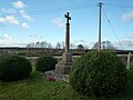 St. James' Church (War Memorial ^ Kimbolton) - geograph.org.uk - 5999670.jpg 3,648 × 2,736; 4.05 MB
-
 Stockton Court (Kimbolton) - geograph.org.uk - 6001465.jpg 3,648 × 2,736; 5.03 MB
-
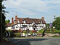 Stockton Cross Inn - geograph.org.uk - 4521782.jpg 3,251 × 2,431; 1.71 MB
-
 Stockton Cross Inn - geograph.org.uk - 5617821.jpg 1,024 × 768; 218 KB
-
 Stockton Cross Inn, Kimbolton - geograph.org.uk - 4789864.jpg 640 × 480; 68 KB
-
 Stockton, A4112 - geograph.org.uk - 2412029.jpg 1,024 × 751; 167 KB
-
 Sundial at St. James' Church (Bell Tower ^ Kimbolton) - geograph.org.uk - 5999673.jpg 3,648 × 2,736; 4.26 MB
-
 The A4112 Road (Kimbolton) - geograph.org.uk - 5996499.jpg 3,648 × 2,736; 4.77 MB
-
 The A4112 Road (Kimbolton) - geograph.org.uk - 5996501.jpg 3,648 × 2,736; 4.89 MB
-
 The A4112 Road (Kimbolton) - geograph.org.uk - 6001469.jpg 2,048 × 1,360; 1.34 MB
-
 The OK Diner at Leominster - geograph.org.uk - 3919972.jpg 640 × 480; 62 KB
-
 The OK Diner, near Ridgemoor Bridge - geograph.org.uk - 2125314.jpg 640 × 480; 208 KB
-
 The old Leominster Canal - geograph.org.uk - 5617814.jpg 1,024 × 768; 298 KB
-
 The remains of the Leominster Canal - geograph.org.uk - 5617730.jpg 1,024 × 768; 407 KB
-

-
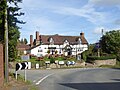
 The Stockton Cross Inn - geograph.org.uk - 3205583.jpg 640 × 480; 65 KB
-
 The Stockton Cross Inn - geograph.org.uk - 5037674.jpg 3,286 × 1,889; 2.13 MB
-
 The Stockton Cross Inn - geograph.org.uk - 5166816.jpg 1,600 × 1,199; 763 KB
-
 The Village of Kimbolton - geograph.org.uk - 5959145.jpg 4,096 × 3,072; 3.46 MB
-
 The Village of Kimbolton - geograph.org.uk - 5996589.jpg 4,096 × 3,072; 3.88 MB
-

-


_-_geograph.org.uk_-_6001334.jpg)


_-_geograph.org.uk_-_6001466.jpg)


_-_geograph.org.uk_-_6001322.jpg)


_-_geograph.org.uk_-_6001329.jpg)


_-_geograph.org.uk_-_5996507.jpg)
_-_geograph.org.uk_-_6001472.jpg)


_-_geograph.org.uk_-_6001437.jpg)
_-_geograph.org.uk_-_5996555.jpg)
_-_geograph.org.uk_-_6000946.jpg)

_-_geograph.org.uk_-_6001468.jpg)


_-_geograph.org.uk_-_6001434.jpg)


_-_geograph.org.uk_-_5996629.jpg)
_-_geograph.org.uk_-_5997428.jpg)
_-_geograph.org.uk_-_5997430.jpg)
_-_geograph.org.uk_-_5997438.jpg)
_-_geograph.org.uk_-_5997445.jpg)
_-_geograph.org.uk_-_5997462.jpg)
_-_geograph.org.uk_-_5997493.jpg)
_-_geograph.org.uk_-_5997505.jpg)
_-_geograph.org.uk_-_5997507.jpg)
_-_geograph.org.uk_-_5997508.jpg)
_-_geograph.org.uk_-_5997510.jpg)
_-_geograph.org.uk_-_5997524.jpg)
_-_geograph.org.uk_-_6001326.jpg)


_-_geograph.org.uk_-_5997528.jpg)


_-_geograph.org.uk_-_5996529.jpg)
_-_geograph.org.uk_-_5996558.jpg)
_-_geograph.org.uk_-_6001314.jpg)
_-_geograph.org.uk_-_5999668.jpg)
_-_geograph.org.uk_-_5999676.jpg)
_-_geograph.org.uk_-_5999679.jpg)
_-_geograph.org.uk_-_6001431.jpg)
_-_geograph.org.uk_-_6001440.jpg)
_-_geograph.org.uk_-_6001447.jpg)
_-_geograph.org.uk_-_6000958.jpg)
_-_geograph.org.uk_-_5999682.jpg)
_-_geograph.org.uk_-_5996553.jpg)
_-_geograph.org.uk_-_5996606.jpg)
_-_geograph.org.uk_-_5996608.jpg)
_-_geograph.org.uk_-_5997523.jpg)
_-_geograph.org.uk_-_5997527.jpg)
_-_geograph.org.uk_-_6001325.jpg)
_-_geograph.org.uk_-_6001331.jpg)
_-_geograph.org.uk_-_6001350.jpg)
_-_geograph.org.uk_-_6001417.jpg)
_-_geograph.org.uk_-_6001423.jpg)
_-_geograph.org.uk_-_6001454.jpg)
_-_geograph.org.uk_-_5999681.jpg)
_-_geograph.org.uk_-_6001321.jpg)
_-_geograph.org.uk_-_5999683.jpg)
_-_geograph.org.uk_-_6001300.jpg)
_-_geograph.org.uk_-_5999678.jpg)
_-_geograph.org.uk_-_6001022.jpg)
_-_geograph.org.uk_-_5999670.jpg)
_-_geograph.org.uk_-_6001465.jpg)


_-_geograph.org.uk_-_5999673.jpg)
_-_geograph.org.uk_-_5996499.jpg)
_-_geograph.org.uk_-_5996501.jpg)
_-_geograph.org.uk_-_6001469.jpg)


_-_geograph.org.uk_-_6001414.jpg)

_-_geograph.org.uk_-_5999684.jpg)