Category:Kingstanding
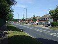
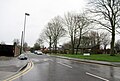
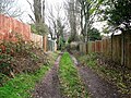
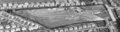
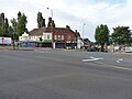
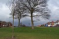
English: Kingstanding, a district of Birmingham, England.
district of Birmingham, England  | |||||
| Upload media | |||||
| Instance of | |||||
|---|---|---|---|---|---|
| Location | Birmingham, West Midlands, England | ||||
| Different from | |||||
 | |||||
Subcategories
This category has the following 8 subcategories, out of 8 total.
K
- Odeon Cinema, Kingstanding (6 F)
- Kingstanding Police Station (4 F)
- Kingstanding Substation (3 F)
L
P
- Post box B44 1465 (5 F)
S
Media in category "Kingstanding"
The following 107 files are in this category, out of 107 total.
-
 A wet Hartley Road, Kingstanding - geograph.org.uk - 5653622.jpg 640 × 480; 54 KB
-

-
 Aldridge Road - geograph.org.uk - 3552479.jpg 640 × 480; 74 KB
-
 Aldridge Road Bridge - geograph.org.uk - 5725232.jpg 800 × 615; 106 KB
-
 Aldridge Road crosses the Tame Valley canal - geograph.org.uk - 5706118.jpg 1,342 × 1,008; 530 KB
-
 Aldridge Road, Perry - geograph.org.uk - 5706116.jpg 1,469 × 1,102; 566 KB
-

-
-
 Banners Walk, Kings Road - geograph.org.uk - 1871837.jpg 640 × 480; 95 KB
-
 Banners Walk, Kingstanding - geograph.org.uk - 1879856.jpg 480 × 640; 74 KB
-

-
 Blocked factory wharf and bridge - geograph.org.uk - 5707201.jpg 2,122 × 1,591; 1.22 MB
-
 Burford Road Playing Fields - geograph.org.uk - 6293315.jpg 4,032 × 1,960; 3.96 MB
-
 Burford Road Playing Fields - geograph.org.uk - 6293319.jpg 4,032 × 1,960; 3.27 MB
-
 Burford Road Playing Fields - geograph.org.uk - 6293333.jpg 4,032 × 1,960; 3.21 MB
-
 Burford Road Playing Fields - geograph.org.uk - 6293336.jpg 4,032 × 1,960; 3.98 MB
-
 Burford Road Playing Fields - geograph.org.uk - 6293339.jpg 4,032 × 1,960; 3.39 MB
-
 Burford Road Playing Fields Main Entrance - geograph.org.uk - 6293328.jpg 1,600 × 778; 445 KB
-

-

-
 College Road Bridge - geograph.org.uk - 5729958.jpg 800 × 575; 83 KB
-
 Court Lane - geograph.org.uk - 19496.jpg 610 × 458; 59 KB
-

-

-

-
-
-

-

-

-

-

-

-

-

-
 Finchley Park, Kingstanding - geograph.org.uk - 1879867.jpg 1,358 × 612; 180 KB
-
 Finchley Park, Kingstanding - geograph.org.uk - 1879870.jpg 800 × 600; 143 KB
-
 Finchley Park, near Homerton Road - geograph.org.uk - 1879880.jpg 1,095 × 615; 150 KB
-
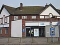
 Former Co-Op store, Kingstanding Road, Birmingham - 2021-01-29 - Andy Mabbett.jpg 4,000 × 3,000; 4.66 MB
-

-
 Georgian postbox on Colindale Road - geograph.org.uk - 5913089.jpg 1,102 × 1,469; 785 KB
-

-

-

-

-

-

-

-

-
 Hawthorn Road, Kingstanding, Birmingham - Andy Mabbett - 2012-07-20 - 02.jpg 3,264 × 1,952; 1.47 MB
-
 Hawthorn Road, Kingstanding, Birmingham - Andy Mabbett - 2012-07-20 - 03.jpg 3,264 × 1,952; 1.4 MB
-

-
 Homerton Road, Kingstanding - geograph.org.uk - 1879888.jpg 1,095 × 615; 229 KB
-
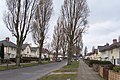
 Houses on Warren Road - geograph.org.uk - 5915847.jpg 1,469 × 1,102; 545 KB
-
 HSBC Bank Kingstanding - geograph.org.uk - 1166607.jpg 640 × 480; 63 KB
-
 Hurlingham Road - geograph.org.uk - 13400.jpg 640 × 426; 112 KB
-
 King's Road at the junction with Harringay Road - geograph.org.uk - 5913099.jpg 1,469 × 1,102; 531 KB
-

-
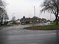
 Kingstanding Circle - geograph.org.uk - 15081.jpg 610 × 458; 63 KB
-
 Kinstanding Road B4138 Kingstanding - geograph.org.uk - 5635176.jpg 640 × 449; 61 KB
-
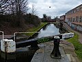
 Low water and lock 8 at Perry Barr - geograph.org.uk - 5706120.jpg 1,469 × 1,102; 816 KB
-
 Mobile phone mast, Kingstanding Circle - 2023-04-06 - Andy Mabbett.jpg 2,297 × 3,063; 2.86 MB
-

-
 On Dulwich Road - geograph.org.uk - 14757.jpg 610 × 407; 60 KB
-

-
 Perry Barr Lock No 10 - geograph.org.uk - 5729983.jpg 800 × 505; 104 KB
-

-

-
 Perry Barr Lock No 9 - geograph.org.uk - 5729990.jpg 800 × 600; 129 KB
-
 Perry Common Public Library - geograph.org.uk - 5915850.jpg 2,611 × 1,958; 1.69 MB
-
-
 Recreation Ground, College Road - geograph.org.uk - 1879900.jpg 1,168 × 656; 206 KB
-
 Red lampposts, grey footpath - geograph.org.uk - 5913083.jpg 1,102 × 1,469; 547 KB
-

-
 Shady Lane, Old Oscott - geograph.org.uk - 33533.jpg 610 × 458; 58 KB
-

-
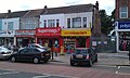
 Shops and businesses at the corner of Finchley Road - geograph.org.uk - 5913103.jpg 1,469 × 1,102; 553 KB
-

-

-
 Stowell Road Kingstanding - geograph.org.uk - 5635173.jpg 640 × 442; 44 KB
-
 Street Atlas of Birmingham - 1939 - Sheet 01 - Kingstanding Road area.jpg 1,024 × 794; 291 KB
-

-

-
 The Deeper Life Bible Church, Kingstanding - geograph.org.uk - 5913095.jpg 1,102 × 1,469; 658 KB
-
 The Hare and Hounds (remains thereof) - geograph.org.uk - 5915864.jpg 1,306 × 979; 504 KB
-
 The King's Standing - geograph.org.uk - 13605.jpg 640 × 426; 107 KB
-
 The Mount Tavern, New Oscott - geograph.org.uk - 5913111.jpg 1,469 × 1,102; 565 KB
-
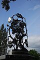
 The Multi Faceted Green Man - Kingstanding Interchange.JPG 2,703 × 2,836; 1.26 MB
-
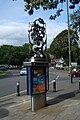 The Mysterious Green Man - Jason Cleverly - 01.JPG 2,000 × 3,008; 2.37 MB
-
 The Mysterious Green Man - Jason Cleverly - 02.JPG 2,000 × 3,008; 2.62 MB
-
 The Mysterious Green Man - Jason Cleverly - 03.JPG 2,000 × 3,008; 2.34 MB
-
 The Mysterious Green Man - Jason Cleverly - 04.JPG 2,000 × 3,008; 2.09 MB
-
 The Mysterious Green Man - Jason Cleverly - 05.JPG 2,000 × 3,008; 2.18 MB
-
 The Mysterious Green Man - Kingstanding Interchange.JPG 2,752 × 2,955; 1.21 MB
-
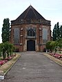 The Ohel in Witton Jewish Cemetery - geograph.org.uk - 5915840.jpg 1,836 × 2,448; 1.49 MB
-

-

-
-
 Traffic island in the dual carriageway - geograph.org.uk - 5913076.jpg 1,247 × 935; 499 KB
-

-

-
-
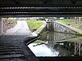
 Under the Aldridge Road Bridge - geograph.org.uk - 5730081.jpg 800 × 564; 80 KB
-
 Under the College Road Bridge - geograph.org.uk - 5729974.jpg 800 × 600; 137 KB
-

-

-
 Woodland path within Sutton Park - geograph.org.uk - 1579452.jpg 640 × 480; 123 KB


_-_geograph.org.uk_-_5653630.jpg)


._The_Kingstanding_Housing_Estate_around_Bandywood_Crescent_under_construction,_Kingstanding,_1938.png)
._The_Kingstanding_Housing_Estate_under_construction,_Kingstanding,_1938.png)
._The_Kingstanding_Housing_Estate_under_construction,_Queslett,_from_the_north-west,_1938.png)
._The_Kingstanding_Housing_Estate_under_construction,_Queslett,_from_the_north-west,_1938.png)
._The_Kingstanding_Housing_Estate_under_construction,_Queslett,_from_the_south-west,_1938.png)
._The_Kingstanding_Housing_Estate_under_construction,_Queslett,_from_the_south-west,_1938.png)
._The_Kingstanding_Housing_Estate_under_construction,_Queslett,_from_the_south-west,_1938.png)


_-_geograph.org.uk_-_5915864.jpg)


._The_Kingstanding_Housing_Estate_around_Bandywood_Crescent_under_construction,_Kingstanding,_1938_(cropped_-_Perry_Barr_Reservoir).png)