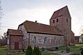
Category:Kirche Holtorf
| Object location | | View all coordinates using: OpenStreetMap |
|---|
 | |||||
| Upload media | |||||
| Instance of | |||||
|---|---|---|---|---|---|
| Location | Schnackenburg, Lüchow-Dannenberg District, Lower Saxony, Germany | ||||
| Heritage designation | |||||
 | |||||
Media in category "Kirche Holtorf"
The following 3 files are in this category, out of 3 total.
-
 Church of Holtorf1.jpg 2,000 × 1,332; 2.16 MB
-
 Church of Holtorf2.jpg 2,000 × 1,333; 2.22 MB
-
 Church of Holtorf3.jpg 2,000 × 1,333; 1.93 MB

