Category:Kirche Reichwalde
| Object location | | View all coordinates using: OpenStreetMap |
|---|
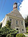
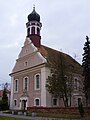
church building in Boxberg/O.L., Germany  | |||||
| Upload media | |||||
| Instance of | |||||
|---|---|---|---|---|---|
| Location | Reichwalde, Boxberg, Görlitz, Saxony, Germany | ||||
| Street address |
| ||||
| Heritage designation | |||||
| Inception |
| ||||
 | |||||
| (Wikidata) |
Subcategories
This category has the following 2 subcategories, out of 2 total.
G
Media in category "Kirche Reichwalde"
The following 25 files are in this category, out of 25 total.
-
 Kirche Reichwalde Juli 2017 (1).jpg 3,648 × 5,472; 4.91 MB
-
 Kirche Reichwalde Juli 2017 (2).jpg 5,472 × 3,648; 5.13 MB
-
 Kirche Reichwalde Juli 2017 (3).jpg 5,472 × 3,648; 5.17 MB
-
 Kirche Reichwalde Juli 2017 (4).jpg 3,648 × 5,472; 5.06 MB
-
 Kirche Reichwalde Juli 2017 (5).jpg 3,648 × 5,472; 5.16 MB
-
 Kirche Reichwalde Juli 2017 (6).jpg 3,648 × 5,472; 5.17 MB
-
 Kirche Reichwalde Juli 2017 (7).jpg 3,648 × 5,472; 4.8 MB
-
 Kirche Reichwalde Juli 2017 (8).jpg 3,648 × 5,472; 5.13 MB
-
 Kirche Reichwalde Juli 2017 (9).jpg 5,472 × 3,648; 5.16 MB
-
 Reichwalde 0001.jpg 1,200 × 804; 312 KB
-
 Reichwalde Gefallenendenkmale.JPG 3,648 × 2,736; 4.19 MB
-
 Reichwalde Kantorscheune (08).JPG 3,648 × 2,736; 3.96 MB
-
 Reichwalde Kantorscheune (09).JPG 3,648 × 2,736; 3.79 MB
-
 Reichwalde Kirche (1).JPG 3,648 × 2,736; 4.19 MB
-
 Reichwalde Kirche (2).JPG 3,648 × 2,736; 4.27 MB
-
 Reichwalde Kirche (3).JPG 2,736 × 3,648; 4 MB
-
 Reichwalde Kirche (4).JPG 2,736 × 3,648; 3.6 MB
-
 Reichwalde Kirche (5).JPG 2,736 × 3,648; 4.06 MB
-
 Reichwalde Kirche (6).JPG 2,736 × 3,648; 4.15 MB
-
 Reichwalde Kirche (7).JPG 3,648 × 2,736; 3.85 MB
-
 Reichwalde Kirche (8).JPG 3,648 × 2,736; 3.91 MB
-
 Reichwalde Kirche (9).JPG 3,648 × 2,736; 3.8 MB
-
 Rychwałd – Cyrkej.jpg 1,944 × 2,592; 805 KB
-
 Rychwałd – cyrkej.jpg 2,900 × 1,933; 2.04 MB
-
 Sachsen, Boxberg, Ortsteil Reichwalde NIK 6112.JPG 4,000 × 6,000; 11.66 MB
.jpg)
.jpg)
.jpg)
.jpg)
.jpg)
.jpg)
.jpg)
.jpg)
.jpg)


.JPG)
.JPG)
.JPG)
.JPG)
.JPG)
.JPG)
.JPG)
.JPG)
.JPG)
.JPG)
.JPG)

