Category:Kirche Rued
| Object location | | View all coordinates using: OpenStreetMap |
|---|
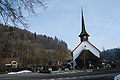
church building in Schlossrued in the canton of Aargau, Switzerland   | |||||
| Upload media | |||||
| Instance of | |||||
|---|---|---|---|---|---|
| Part of | |||||
| Location | Schlossrued, Kulm District, Aargau, Switzerland | ||||
| Street address |
| ||||
| Heritage designation | |||||
 | |||||
Subcategories
This category has only the following subcategory.
S
Media in category "Kirche Rued"
The following 15 files are in this category, out of 15 total.
-
 Kirchrued Kirche 025a.jpg 1,024 × 683; 118 KB
-
 Kirchrued Kirche 026.jpg 889 × 768; 323 KB
-
 Kirchrued Kirche 026a.jpg 721 × 1,024; 355 KB
-
 Kirchrued Kirche 040.jpg 683 × 1,024; 291 KB
-
 Kirchrued Kirche 041.jpg 683 × 1,024; 364 KB
-
 Kirchrued Kirche Grabplatte aussen 037.jpg 1,024 × 555; 288 KB
-
 Kirchrued Kirche Grabplatte aussen 038.jpg 564 × 1,024; 267 KB
-
 Kirchrued Kirche Grabplatte aussen 039.jpg 721 × 1,024; 450 KB
-
 Kirchrued Kirche Grabplatte innen 029.jpg 678 × 1,024; 322 KB
-
 Kirchrued Kirche Grabplatte innen 030.jpg 636 × 1,024; 279 KB
-
 Kirchrued Kirche Grabplatte innen 034.jpg 636 × 1,024; 278 KB
-
 Kirchrued Kirche innen 028.jpg 1,024 × 683; 244 KB
-
 Kirchrued Kirche innen 031.jpg 1,024 × 683; 254 KB
-
 Kirchrued preghejo (komunumo Schlossrued) 130.jpg 3,872 × 2,592; 3.42 MB
-
 Kirchrued preghejo (komunumo Schlossrued) 132.jpg 3,872 × 2,592; 4.34 MB


_130.jpg)
_132.jpg)