Category:Kirche Würzbrunnen
| Object location | | View all coordinates using: OpenStreetMap |
|---|
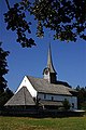
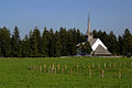
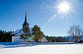
church building in Röthenbach im Emmental in the canton of Bern, Switzerland   | |||||
| Upload media | |||||
| Instance of | |||||
|---|---|---|---|---|---|
| Part of | |||||
| Named after | |||||
| Location | Röthenbach im Emmental, Emmental administrative district, Emmental-Oberaargau administrative region, Bern, Switzerland | ||||
| Street address |
| ||||
| Heritage designation | |||||
| Inception |
| ||||
| Elevation above sea level |
| ||||
| official website | |||||
 | |||||
Media in category "Kirche Würzbrunnen"
The following 31 files are in this category, out of 31 total.
-
 2004-Roethenbach-Kirche-Wuerzbrunnen.jpg 1,280 × 1,920; 2.51 MB
-
 Church In The Moonlight (94697691).jpg 1,200 × 801; 301 KB
-
 KGS Wuerzbrunnen-01.JPG 1,200 × 1,600; 1.12 MB
-
 KGS-Wtb Würzbrunnen-(5).jpg 2,816 × 2,112; 1.46 MB
-

-
-

-

-

-
-
 Picswiss BE-94-08 Kirche von Würzbrunnen (Röthenbach).jpg 500 × 333; 47 KB
-
 RFP8051.jpg 3,114 × 4,701; 1.58 MB
-
 RFP8058.jpg 4,920 × 3,259; 1.24 MB
-
 RFP8059.jpg 4,928 × 3,264; 1.26 MB
-
 Roethenbach Kirche Wuerzbrunnen-1.jpg 3,950 × 2,633; 9.35 MB
-
 Roethenbach Kirche Wuerzbrunnen-2.jpg 3,607 × 2,371; 7.22 MB
-
 Roethenbach Kirche Wuerzbrunnen-3.jpg 3,333 × 2,191; 5.53 MB
-
 Roethenbach Wuerzbrunnen Kirche.jpg 500 × 333; 35 KB
-
 Wuerzbr08.Nostalgic.jpg 5,184 × 3,456; 3.64 MB
-
 Wuerzbr08.Vintage.jpg 5,184 × 3,456; 3.94 MB
-
 Wuerzbr08.vo dyn hart.jpg 5,184 × 3,456; 3.69 MB
-
 Wuerzbrunnen 1170.jpg 2,048 × 1,365; 1.34 MB
-
 Wuerzbrunnen 1174.jpg 4,787 × 3,191; 3.49 MB
-
 Wuerzbrunnen Glasfenster.jpg 1,500 × 1,500; 1.75 MB
-
 Wuerzbrunnen01.jpg 1,365 × 2,048; 794 KB
-
 Wuerzbrunnenkirche im Winter 2.jpg 2,000 × 1,333; 1.93 MB
-
 Wuerzbrunnenkirche Innenraum.jpg 2,000 × 1,333; 2.77 MB
-
 Wuerzbrunnenkirche.jpg 2,000 × 1,500; 2 MB
-
 Würzbrunnen Kirche Eingang Friedhof.jpg 5,396 × 3,598; 14.63 MB
-
 Würzbrunnen Kirche von der Ostseite.jpg 3,786 × 3,786; 8.94 MB
-
 Würzbrunnen.jpg 3,888 × 2,592; 4.05 MB

.jpg)

.jpg)
.jpg)
.jpg)
.jpg)
.jpg)
.jpg)
_-_%22Gotthelf-Kirche%22.jpg)
.jpg)


