Category:Kleiner Fähnrichshof, Blutgasse 9, Vienna
| Object location | | View all coordinates using: OpenStreetMap |
|---|
building in Innere Stadt, Austria  | |||||
| Upload media | |||||
| Instance of |
| ||||
|---|---|---|---|---|---|
| Location | Innere Stadt, Vienna, Austria | ||||
| Street address |
| ||||
| Heritage designation | |||||
 | |||||
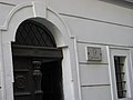
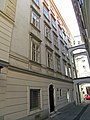
Deutsch: Bürgerhaus Kleiner Fähnrichshof, Teil des Häuserkomplexes Fähnrichshof. Blutgasse 9, Wien-Innere Stadt.
Media in category "Kleiner Fähnrichshof, Blutgasse 9, Vienna"
The following 7 files are in this category, out of 7 total.
-
 Blutg.9 455.JPG 3,264 × 2,448; 1.66 MB
-
 Blutg.9 459.JPG 2,448 × 3,264; 3.53 MB
-
 Blutgasse 06.JPG 2,304 × 3,072; 1.62 MB
-
 Blutgasse 07.JPG 2,304 × 3,072; 1.62 MB
-
 Blutgasse 9.jpg 2,136 × 2,848; 1.47 MB
-
 Wien Hof neben der Blutgasse stitched 2009 PD.jpg 3,630 × 11,701; 5.05 MB
-
 Wien Zentrum 2009 PD 20091006 013.JPG 2,848 × 4,272; 3.31 MB


