Category:Klosterruine Boitzenburg
| Object location | | View all coordinates using: OpenStreetMap |
|---|
church ruin  | |||||
| Upload media | |||||
| Instance of | |||||
|---|---|---|---|---|---|
| Part of | |||||
| Location | Boitzenburger Land, Uckermark District, Brandenburg, Germany | ||||
| Heritage designation | |||||
 | |||||
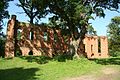
This is the category of the Brandenburger Baudenkmal (cultural heritage monument) with the ID 09130380 (Wikidata)
|
English: Ruin of monastery church in Boitzenburg, Boitzenburger Land municipality, Uckermark district, Brandenburg state, Germany
Deutsch: Ruine der Klosterkirche in Boitzenburg, Gemeinde Boitzenburger Land, Landkreis Uckermark, Land Brandenburg, Deutschland.
Français : Ruine de l'église du monastère de Boitzenburg, commune de Boitzenburger Land, arrondissement Uckermark, état fédéral de Brandebourg, Allemagne
Media in category "Klosterruine Boitzenburg"
The following 7 files are in this category, out of 7 total.
-
 BoitzenburgKlosterruine03 jiw.jpg 1,920 × 1,280; 942 KB
-
 Klosterruine Boitzenburg 1.jpg 5,759 × 3,839; 19.26 MB
-
 Klosterruine Boitzenburg 2.jpg 5,765 × 3,845; 16.5 MB
-
 Klosterruine.jpg 900 × 675; 218 KB
-
 RK 0908 3817 Klosterruine Boitzenburg.jpg 1,500 × 1,000; 1 MB
-
 RK 0908 3818 Klosterruine Boitzenburg.jpg 1,500 × 1,000; 949 KB
-
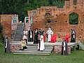 Theater Klosterruine Boitzenburg.jpg 3,072 × 2,304; 1.18 MB


