Category:Kokanee Glacier Provincial Park
| Object location | | View all coordinates using: OpenStreetMap |
|---|
Canadian provincial park  | |||||
| Upload media | |||||
| Instance of | |||||
|---|---|---|---|---|---|
| Location | Regional District of Central Kootenay, British Columbia, Canada | ||||
| IUCN protected areas category | |||||
| Inception |
| ||||
| Area |
| ||||
| official website | |||||
 | |||||
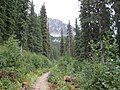
English: Kokanee Glacier Provincial Park is one of the oldest provincial parks in British Columbia, established in 1922. The park has an area of and is located in the Selkirk Mountains in the West Kootenays region of BC. The park has three glaciers (Kokanee, Caribou, and Woodbury) that feed over 30 alpine lakes which are the headwaters of many creeks.
Media in category "Kokanee Glacier Provincial Park"
The following 10 files are in this category, out of 10 total.
-
 Kokanee Glacier Cabin, Living room - panoramio.jpg 1,280 × 960; 370 KB
-
 Kokaneeglacierprovpark.JPG 1,600 × 1,200; 478 KB
-
 Parc provincial du Kokanee Glacier01.jpg 2,080 × 1,544; 1,010 KB
-
 Parc provincial du Kokanee Glacier02 (cropped).jpg 2,080 × 297; 273 KB
-
 Parc provincial du Kokanee Glacier02.jpg 2,080 × 1,544; 1.04 MB
-
 Parc provincial du Kokanee Glacier03.jpg 2,080 × 1,544; 1,007 KB
-
 Parc provincial du Kokanee Glacier04.jpg 2,080 × 1,544; 1.06 MB
-
 Parc provincial du Kokanee Glacier05.jpg 2,080 × 1,544; 1.11 MB
-
 Parc provincial du Kokanee Glacier06.jpg 1,544 × 2,080; 1.03 MB
-
 Parc provincial du Kokanee Glacier07.jpg 2,080 × 1,544; 800 KB


.jpg)