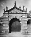
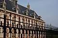
Category:Koninklijk Weeshuis (Buren)
| Object location | | View all coordinates using: OpenStreetMap |
|---|
building in Buren, Netherlands  | |||||
| Upload media | |||||
| Instance of | |||||
|---|---|---|---|---|---|
| Location | Buren, Gelderland, Netherlands | ||||
| Street address |
| ||||
| Located on street |
| ||||
| Occupant | |||||
| Heritage designation |
| ||||
 | |||||
Nederlands: Voormalig Koninklijk Weeshuis, thans Marechaussee Museum te Buren (Gelderland)
|
This is a category about rijksmonument number 11388
|
| Address |
|
Media in category "Koninklijk Weeshuis (Buren)"
The following 160 files are in this category, out of 160 total.
-
 11388 Weeshuis Buren 2.jpg 3,000 × 2,115; 5.09 MB
-
 11388 Weeshuis Buren.jpg 3,000 × 2,301; 6.85 MB
-
 4116 Buren, Netherlands - panoramio (100).jpg 2,048 × 1,155; 567 KB
-
 4116 Buren, Netherlands - panoramio (104).jpg 2,048 × 1,155; 552 KB
-
 4116 Buren, Netherlands - panoramio (2).jpg 2,048 × 1,375; 516 KB
-
 4116 Buren, Netherlands - panoramio (20).jpg 2,048 × 1,148; 505 KB
-
 4116 Buren, Netherlands - panoramio (21).jpg 2,048 × 1,148; 615 KB
-
 4116 Buren, Netherlands - panoramio (25).jpg 2,048 × 1,148; 695 KB
-
 4116 Buren, Netherlands - panoramio (29).jpg 2,048 × 1,148; 394 KB
-
 4116 Buren, Netherlands - panoramio (30).jpg 2,048 × 1,148; 619 KB
-
 4116 Buren, Netherlands - panoramio (32).jpg 1,148 × 2,048; 341 KB
-
 4116 Buren, Netherlands - panoramio (36).jpg 2,048 × 1,148; 442 KB
-
 4116 Buren, Netherlands - panoramio (43).jpg 2,048 × 1,148; 670 KB
-
 4116 Buren, Netherlands - panoramio (45).jpg 2,048 × 1,148; 486 KB
-
 4116 Buren, Netherlands - panoramio (48).jpg 2,048 × 1,148; 391 KB
-
 4116 Buren, Netherlands - panoramio (49).jpg 1,148 × 2,048; 431 KB
-
 4116 Buren, Netherlands - panoramio (50).jpg 2,048 × 1,148; 342 KB
-
 4116 Buren, Netherlands - panoramio (51).jpg 2,048 × 1,148; 489 KB
-
 4116 Buren, Netherlands - panoramio (52).jpg 2,048 × 1,148; 334 KB
-
 4116 Buren, Netherlands - panoramio (53).jpg 2,048 × 1,148; 497 KB
-
 4116 Buren, Netherlands - panoramio (54).jpg 2,048 × 1,148; 510 KB
-
 4116 Buren, Netherlands - panoramio (55).jpg 1,148 × 2,048; 460 KB
-
 4116 Buren, Netherlands - panoramio (60).jpg 2,048 × 1,148; 456 KB
-
 4116 Buren, Netherlands - panoramio (63).jpg 2,048 × 1,148; 506 KB
-
 4116 Buren, Netherlands - panoramio (64).jpg 2,048 × 1,148; 511 KB
-
 4116 Buren, Netherlands - panoramio (67).jpg 2,048 × 1,148; 610 KB
-
 4116 Buren, Netherlands - panoramio (73).jpg 4,896 × 3,264; 2.47 MB
-
 4116 Buren, Netherlands - panoramio (74).jpg 4,896 × 3,264; 3.3 MB
-
 4116 Buren, Netherlands - panoramio (78).jpg 4,896 × 3,264; 2.8 MB
-
 4116 Buren, Netherlands - panoramio (82).jpg 4,896 × 3,264; 1.93 MB
-
 4116 Buren, Netherlands - panoramio (99).jpg 2,048 × 1,155; 510 KB
-
 4116 Buren, Netherlands - panoramio - Ben Bender (2).jpg 4,896 × 3,264; 6.62 MB
-
 4116 Buren, Netherlands - panoramio - Ben Bender (3).jpg 4,896 × 3,264; 6.82 MB
-
 4116 Buren, Netherlands - panoramio - Ben Bender (4).jpg 4,896 × 3,264; 5.96 MB
-
 4116 Buren, Netherlands - panoramio - Ben Bender (5).jpg 4,896 × 3,264; 5.23 MB
-
 4116 Buren, Netherlands - panoramio - Ben Bender (6).jpg 4,896 × 3,264; 4.73 MB
-
 4116 Buren, Netherlands - panoramio.jpg 4,896 × 3,264; 6.42 MB
-
 Aanzicht beeld op fronton voorpoort - Buren - 20371145 - RCE.jpg 791 × 1,200; 150 KB
-
 Achtergevel - Buren - 20326924 - RCE.jpg 880 × 1,200; 210 KB
-
 B27.5.png 307 × 230; 61 KB
-
 Beeld boven op de toegangspoort - Buren - 20045561 - RCE.jpg 944 × 1,200; 294 KB
-
 Beeld boven op de toegangspoort - Buren - 20045562 - RCE.jpg 947 × 1,200; 256 KB
-
 Beeld op toegangspoort - Buren - 20045560 - RCE.jpg 948 × 1,200; 250 KB
-
 Beeld van poortgebouw - Buren - 20045587 - RCE.jpg 1,197 × 1,200; 230 KB
-
 Beeld van poortgebouw - Buren - 20045588 - RCE.jpg 1,185 × 1,200; 235 KB
-
 Beeld van poortgebouw - Buren - 20045589 - RCE.jpg 1,200 × 1,200; 209 KB
-
 Beeld van poortgebouw - Buren - 20045590 - RCE.jpg 1,200 × 1,200; 254 KB
-
 Beeld van poortgebouw - Buren - 20045591 - RCE.jpg 1,186 × 1,200; 193 KB
-
 Beeld van poortgebouw - Buren - 20045592 - RCE.jpg 1,200 × 1,190; 218 KB
-
 Beeld van poortgebouw - Buren - 20045593 - RCE.jpg 1,200 × 1,200; 230 KB
-
 Beeld van poortgebouw - Buren - 20045594 - RCE.jpg 1,190 × 1,200; 229 KB
-
 Beeld van poortgebouw - Buren - 20045595 - RCE.jpg 1,190 × 1,200; 213 KB
-
 Beeld van poortgebouw - Buren - 20045596 - RCE.jpg 1,195 × 1,200; 210 KB
-
 Beeld van poortgebouw - Buren - 20045597 - RCE.jpg 1,200 × 1,190; 229 KB
-
 Beeld van poortgebouw - Buren - 20045598 - RCE.jpg 1,200 × 1,192; 219 KB
-

-
 Beeld van poortgebouw. - Buren - 20045599 - RCE.jpg 1,174 × 1,200; 228 KB
-
 Buren weeshuis.jpg 400 × 300; 109 KB
-
 Buren, het koninklijk weeshuis RM11388 achter de vestingwerken foto8 2016-10-05 11.03.jpg 4,204 × 3,153; 10.99 MB
-
 Buren-024.JPG 3,264 × 2,448; 2.21 MB
-
 Buren. Het voormalige Weeshuis. Nu Marchauceekazerne.jpg 4,770 × 3,177; 2.71 MB
-
 Deel gevel met deur - Buren - 20326927 - RCE.jpg 868 × 1,200; 261 KB
-
 Detail bovenste deel gevel en dakkapel - Buren - 20045572 - RCE.jpg 1,200 × 867; 314 KB
-
 Detail ingang en raam daarboven 1613 - Buren - 20045571 - RCE.jpg 889 × 1,200; 286 KB
-
 Detail of the central entrance of the Buren MP Museum dated 1613 - panoramio.jpg 2,848 × 4,288; 5.53 MB
-
 Eikenkast - Buren - 20045573 - RCE.jpg 962 × 1,200; 214 KB
-
 Exterieur - Buren - 20045566 - RCE.jpg 881 × 1,200; 200 KB
-

-

-

-

-

-

-

-

-

-

-

-
-
 Exterieur LEIDEKKER TIJDENS WERKZAAMHEDEN - Buren - 20260877 - RCE.jpg 1,200 × 775; 183 KB
-
 Exterieur LEIDEKKER TIJDENS WERKZAAMHEDEN - Buren - 20260878 - RCE.jpg 1,200 × 775; 185 KB
-
 Exterieur LEIDEKKER TIJDENS WERKZAAMHEDEN - Buren - 20260879 - RCE.jpg 1,200 × 775; 182 KB
-
 Exterieur LEIDEKKER TIJDENS WERKZAAMHEDEN - Buren - 20260880 - RCE.jpg 1,200 × 775; 179 KB
-
 Exterieur naar het noord-oosten - Buren - 20045558 - RCE.jpg 1,200 × 948; 269 KB
-
 Exterieur naar het noord-oosten - Buren - 20377483 - RCE.jpg 1,200 × 951; 278 KB
-
 Exterieur oost zijde naar het zuid-westen - Buren - 20045557 - RCE.jpg 943 × 1,200; 317 KB
-
 Exterieur OVERZICHT VOORGEVEL - Buren - 20260859 - RCE.jpg 1,200 × 801; 231 KB
-
 Exterieur OVERZICHT VOORGEVEL MET TOEGANGSPOORT - Buren - 20339458 - RCE.jpg 1,198 × 1,200; 350 KB
-
 Exterieur OVERZICHT ZIJGEVEL - Buren - 20260861 - RCE.jpg 1,200 × 789; 223 KB
-
 Exterieur VOORGEVEL - Buren - 20260860 - RCE.jpg 1,200 × 770; 233 KB
-
 Exterieur VOORGEVEL - Buren - 20260863 - RCE.jpg 1,200 × 775; 233 KB
-
 Exterieur ZIJGEVEL - Buren - 20260862 - RCE.jpg 1,200 × 791; 212 KB
-
 Exterieur ZIJGEVEL - Buren - 20260864 - RCE.jpg 1,200 × 775; 230 KB
-
 Fronton van de poort - Buren - 20045555 - RCE.jpg 1,187 × 1,200; 307 KB
-
 Fronton van de poort - Buren - 20045556 - RCE.jpg 1,200 × 930; 263 KB
-
 Gevelsteen boven entree weeshuis - Buren - 20365252 - RCE.jpg 1,200 × 789; 243 KB
-
 Gezien vanuit het oosten met Kerk en weeshuis - Buren - 20045095 - RCE.jpg 1,200 × 1,186; 392 KB
-
 Hoek van twee gevels - Buren - 20326926 - RCE.jpg 865 × 1,200; 254 KB
-

-
 Ingang met tekstplaat - Buren - 20045565 - RCE.jpg 879 × 1,200; 320 KB
-
 Ingang met tekstplaat - Buren - 20045580 - RCE.jpg 894 × 1,200; 251 KB
-
 Ingangspoortje - Buren - 20045570 - RCE.jpg 936 × 1,200; 344 KB
-
 Interieur regentenkamer - Buren - 20326923 - RCE.jpg 1,200 × 877; 148 KB
-
 Interieur trap - Buren - 20326880 - RCE.jpg 1,200 × 850; 135 KB
-

-
 Lage gevel - Buren - 20326929 - RCE.jpg 1,200 × 862; 235 KB
-
 LiaKrol Wezen.JPG 1,937 × 2,700; 2.07 MB
-
 LiaKrol Wezen2.JPG 2,712 × 3,616; 3.8 MB
-
 Marechaussee Museum (Museum of the Dutch Militairy Police) at Buren - panoramio.jpg 4,288 × 2,848; 5.82 MB
-
 Museum der Koninklijke Marechaussee in Buren.JPG 3,648 × 2,736; 4.33 MB
-
 Overzicht "Commanderij", achtergevel weeshuis - Buren - 20045159 - RCE.jpg 1,200 × 1,174; 312 KB
-
 Overzicht - Buren - 20045579 - RCE.jpg 1,200 × 894; 309 KB
-
 Overzicht achterzijde - Buren - 20045582 - RCE.jpg 1,200 × 861; 239 KB
-
 Overzicht hoofdingang weeshuis - Buren - 20322276 - RCE.jpg 889 × 1,200; 277 KB
-
 Overzicht hoofdvleugel met dakruiter - Buren - 20045563 - RCE.jpg 1,200 × 892; 271 KB
-
 Overzicht hoofdvleugel met dakruiter - Buren - 20045564 - RCE.jpg 1,200 × 897; 302 KB
-

-
 Overzicht voorgevel - Buren - 20045583 - RCE.jpg 1,200 × 955; 328 KB
-
 Overzicht voorgevel - Buren - 20326932 - RCE.jpg 1,200 × 869; 217 KB
-
 Overzicht voorgevel - Buren - 20375320 - RCE.jpg 1,200 × 1,182; 320 KB
-
 Overzicht voorgevel - Buren - 20411878 - RCE.jpg 1,200 × 1,194; 340 KB
-
 Overzicht voorgevel en rechter zijgevel - Buren - 20359457 - RCE.jpg 1,192 × 1,200; 360 KB
-
 Overzicht voorgevel en rechter zijgevel - Buren - 20359782 - RCE.jpg 1,199 × 1,200; 242 KB
-
 Overzicht voorgevel en toegangspoortje - Buren - 20359784 - RCE.jpg 1,200 × 1,187; 262 KB
-
 Overzicht voorgevel voorpoort - Buren - 20371146 - RCE.jpg 1,200 × 783; 256 KB
-
 Overzicht Weeshuiswal - Buren - 20045144 - RCE.jpg 1,200 × 1,176; 348 KB
-
 Overzicht Weeshuiswal - Buren - 20045151 - RCE.jpg 1,200 × 1,170; 392 KB
-
 Overzicht Weeshuiswal - Buren - 20045152 - RCE.jpg 1,200 × 1,172; 349 KB
-
 Overzicht Weeshuiswal - Buren - 20045153 - RCE.jpg 1,200 × 1,176; 350 KB
-

-

-

-
 Pinakel van poortgebouw - Buren - 20045600 - RCE.jpg 1,188 × 1,200; 225 KB
-
 Poort - Buren - 20045568 - RCE.jpg 888 × 1,200; 202 KB
-
 Reproductie van tekening in bezit Archief Weeshuis - Buren - 20045548 - RCE.jpg 1,200 × 942; 165 KB
-
 Reproductie van tekening in bezit Archief Weeshuis - Buren - 20045549 - RCE.jpg 1,123 × 1,200; 251 KB
-
 Reproductie van tekening in bezit Archief Weeshuis - Buren - 20045550 - RCE.jpg 1,200 × 817; 178 KB
-
 Reproductie van tekening in bezit Archief Weeshuis - Buren - 20045551 - RCE.jpg 1,200 × 964; 190 KB
-
 Reproductie van tekening in bezit Archief Weeshuis - Buren - 20045552 - RCE.jpg 1,200 × 938; 191 KB
-
 Reproductie van tekening in bezit Archief Weeshuis - Buren - 20045553 - RCE.jpg 1,109 × 1,200; 222 KB
-
 Schilderij - Buren - 20045577 - RCE.jpg 950 × 1,200; 223 KB
-
 Schilderij - Buren - 20045578 - RCE.jpg 942 × 1,200; 234 KB
-
 Stadsoverzicht van af de Toren - Buren - 20045105 - RCE.jpg 1,200 × 1,190; 419 KB
-
 T.T Weeshuis Buren.JPG 1,984 × 1,488; 671 KB
-
 Tafel - Buren - 20045574 - RCE.jpg 1,200 × 961; 290 KB
-
 Tafel - Buren - 20045576 - RCE.jpg 1,200 × 944; 280 KB
-
 Tafel regentenkamer - Buren - 20045575 - RCE.jpg 1,200 × 894; 203 KB
-
 Toegangspoort - Buren - 20045569 - RCE.jpg 951 × 1,200; 332 KB
-
 Twee gevels - Buren - 20326925 - RCE.jpg 1,200 × 874; 289 KB
-
 Uit het zuid-westen - Buren - 20045732 - RCE.jpg 1,200 × 812; 230 KB
-
 Voorgevel - Buren - 20045554 - RCE.jpg 1,200 × 880; 239 KB
-
 Voorgevel - Buren - 20045584 - RCE.jpg 964 × 1,200; 307 KB
-
 Voorgevel - Buren - 20045585 - RCE.jpg 825 × 1,200; 253 KB
-
 Voorgevel - Buren - 20326462 - RCE.jpg 1,200 × 819; 312 KB
-
 Voorpoort - Buren - 20045567 - RCE.jpg 1,022 × 1,200; 313 KB
-
 Wapen Marechaussee museum Buren.JPG 2,736 × 2,052; 1.77 MB
-
 Weeshuis thans museum.jpg 4,557 × 3,418; 12.14 MB
-
 WLM - Ciao Anita! - Buren - Weeshuis (1).jpg 3,503 × 2,460; 4.97 MB
-
 WLM - Ciao Anita! - Buren - Weeshuis (2).jpg 3,752 × 2,457; 4.69 MB
-
 WLM - Ciao Anita! - Buren - Weeshuis.jpg 3,872 × 2,592; 4.41 MB


.jpg)
.jpg)
.jpg)
.jpg)
.jpg)
.jpg)
.jpg)
.jpg)
.jpg)
.jpg)
.jpg)
.jpg)
.jpg)
.jpg)
.jpg)
.jpg)
.jpg)
.jpg)
.jpg)
.jpg)
.jpg)
.jpg)
.jpg)
.jpg)
.jpg)
.jpg)
.jpg)
.jpg)
.jpg)
.jpg)
.jpg)
.jpg)
.jpg)
.jpg)


_-_Buren_-_20260866_-_RCE.jpg)
_-_Buren_-_20260867_-_RCE.jpg)
_-_Buren_-_20260868_-_RCE.jpg)
_-_Buren_-_20260869_-_RCE.jpg)
_-_Buren_-_20260870_-_RCE.jpg)
_-_Buren_-_20260871_-_RCE.jpg)
_-_Buren_-_20260872_-_RCE.jpg)
_-_Buren_-_20260873_-_RCE.jpg)
_-_Buren_-_20260874_-_RCE.jpg)
_-_Buren_-_20260875_-_RCE.jpg)
_-_Buren_-_20260876_-_RCE.jpg)
_-_Buren_-_20260865_-_RCE.jpg)


_at_Buren_-_panoramio.jpg)


.jpg)
.jpg)
