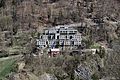
Category:Konviktsgebäude (Arosastrasse 32, Chur)
| Object location | | View all coordinates using: OpenStreetMap |
|---|
church building in Chur in the canton of Grisons, Switzerland .jpg) | |||||
| Upload media | |||||
| Instance of | |||||
|---|---|---|---|---|---|
| Part of | |||||
| Location |
| ||||
| Street address |
| ||||
| Heritage designation | |||||
 | |||||
Media in category "Konviktsgebäude (Arosastrasse 32, Chur)"
This category contains only the following file.
-
 Chur - Konvikt (16972965980).jpg 5,273 × 3,516; 16.73 MB