Category:Kromme Waal 20, Amsterdam
| Object location | | View all coordinates using: OpenStreetMap |
|---|
building in Amsterdam, Netherlands  | |||||
| Upload media | |||||
| Instance of | |||||
|---|---|---|---|---|---|
| Location | Amsterdam, North Holland, Netherlands | ||||
| Street address |
| ||||
| Located on street | |||||
| Heritage designation |
| ||||
 | |||||
|
This is a category about rijksmonument number 6215
|
| Address |
|
Media in category "Kromme Waal 20, Amsterdam"
The following 7 files are in this category, out of 7 total.
-
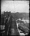 Jacob Olie (1863) - Oude Waal 42, 41, 40 enz. (links, v.l.n.r.).jpg 5,067 × 5,959; 4.78 MB
-
 Jacob Olie (1896) - Kromme Waal 2-38 (v.r.n.l.).jpg 7,048 × 5,637; 6.8 MB
-
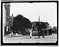
 Waalseilandsgracht, foto 5 Jacob Olie (max res).jpg 4,961 × 3,808; 3.44 MB
-
 WLM - andrevanb - amsterdam, kromme waal 20 - detail (1).jpg 1,200 × 900; 397 KB
-
 WLM - andrevanb - amsterdam, kromme waal 20 - detail.jpg 1,200 × 900; 380 KB
-
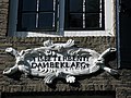 WLM - andrevanb - amsterdam, kromme waal 20, detail.jpg 1,200 × 900; 475 KB
-
 WLM - andrevanb - amsterdam, kromme waal 20.jpg 814 × 1,200; 413 KB
_-_Oude_Waal_42,_41,_40_enz._(links,_v.l.n.r.).jpg)
_-_Kromme_Waal_2-38_(v.r.n.l.).jpg)
.jpg)
.jpg)

