Category:Lämmerenhütte
| Object location | | View all coordinates using: OpenStreetMap |
|---|
  | |||||
| Upload media | |||||
| Instance of | |||||
|---|---|---|---|---|---|
| Location | Valais, Switzerland | ||||
| Owned by | |||||
| Inception |
| ||||
| Mountain range | |||||
| Elevation above sea level |
| ||||
| official website | |||||
 | |||||
Media in category "Lämmerenhütte"
The following 11 files are in this category, out of 11 total.
-
 Bridge over Lämmerendalu.jpg 5,456 × 3,632; 5.4 MB
-
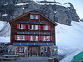 Lämmeren hut.jpg 1,600 × 1,200; 317 KB
-
 Lämmerengletscher 2.jpg 5,456 × 3,632; 5.78 MB
-
 Lämmerenhutte 3.jpg 4,464 × 2,777; 3.34 MB
-
 Lämmerenhutte yard.jpg 5,209 × 3,457; 4.53 MB
-
 Lämmerenhütte Spherical Panorama.jpg 6,080 × 3,040; 2.83 MB
-
 Lämmerenhütte.jpg 5,248 × 3,232; 4.53 MB
-
 Stones on trail.jpg 5,456 × 3,632; 5.45 MB
-
 Trail in Switzerland.jpg 5,456 × 3,632; 6.08 MB
-
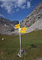 Trail signs near Lämmerenhutte.jpg 3,632 × 5,145; 4.89 MB
-
 Trail signs on Gemmipass.jpg 1,936 × 3,112; 2.27 MB


