Category:Ladykirk and Norham Bridge
bridge on the English-Scottish border UK, carries the B6470 road across River Tweed .jpg) | |||||
| Upload media | |||||
| Instance of | |||||
|---|---|---|---|---|---|
| Location |
| ||||
| Crosses | |||||
| Carries |
| ||||
| Heritage designation |
| ||||
 | |||||
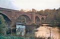
Ladykirk and Norham Bridge, which connects Ladykirk in the Borders, Scotland, with Norham in Northumberland, England, is a bridge in the United Kingdom that spans the River Tweed.
Media in category "Ladykirk and Norham Bridge"
The following 15 files are in this category, out of 15 total.
-
 Bridge over River Tweed at Norham - geograph.org.uk - 139198.jpg 640 × 480; 94 KB
-
 Ladykirk and Norham - geograph.org.uk - 572632.jpg 640 × 480; 64 KB
-
 Ladykirk and Norham Bridge (geograph 3396225).jpg 800 × 600; 126 KB
-
 Ladykirk and Norham Bridge - geograph.org.uk - 3396212.jpg 800 × 600; 123 KB
-
 Ladykirk and Norham Bridge - geograph.org.uk - 4224391.jpg 1,950 × 1,380; 640 KB
-
 Ladykirk and Norham Bridge in 2003.jpg 424 × 279; 30 KB
-
 Ladykirk and Norham Bridge over the Tweed (2) - geograph.org.uk - 5054105.jpg 1,024 × 678; 212 KB
-
 Ladykirk and Norham Bridge over the Tweed (3) - geograph.org.uk - 5054137.jpg 1,024 × 678; 181 KB
-
 Ladykirk ^ Norham Bridge - geograph.org.uk - 5011349.jpg 640 × 480; 73 KB
-
 Plaque, Ladykirk and Norham Bridge - geograph.org.uk - 2611235.jpg 481 × 640; 65 KB
-
 River Tweed - geograph.org.uk - 503446.jpg 640 × 480; 60 KB
-
 The Ladykirk and Norham Bridge. River Tweed crossing point. View downstream.jpg 4,896 × 2,752; 2.01 MB
-
 The Ladykirk and Norham Bridge. View of toll house. River Tweed crossing point.jpg 4,896 × 2,752; 3.46 MB
-
 The River Tweed from the Ladykirk and Norham Bridge. View upstream.jpg 4,896 × 2,752; 2.36 MB
-


_-_geograph.org.uk_-_5054105.jpg)
_-_geograph.org.uk_-_5054137.jpg)


