Category:Lanier County, Georgia
Counties of Georgia: Appling · Atkinson · Bacon · Baker · Baldwin · Banks · Barrow · Bartow · Ben Hill · Berrien · Bleckley · Brantley · Brooks · Bryan · Bulloch · Burke · Butts · Calhoun · Camden · Campbell · Candler · Carroll · Catoosa · Charlton · Chatham · Chattooga · Cherokee · Clay · Clayton · Clinch · Cobb · Coffee · Colquitt · Columbia · Cook · Coweta · Crawford · Crisp · Dade · Dawson · Decatur · DeKalb · Dodge · Dooly · Dougherty · Douglas · Early · Effingham · Elbert · Emanuel · Evans · Fannin · Fayette · Floyd · Forsyth · Franklin · Fulton · Gilmer · Glascock · Glynn · Gordon · Grady · Greene · Gwinnett · Habersham · Hall · Hancock · Haralson · Harris · Hart · Heard · Henry · Houston · Irwin · Jackson · Jasper · Jeff Davis · Jefferson · Jenkins · Johnson · Jones · Lamar · Lanier · Laurens · Lee · Liberty · Lincoln · Long · Lowndes · Lumpkin · Macon · Madison · Marion · McDuffie · McIntosh · Meriwether · Miller · Milton · Mitchell · Monroe · Montgomery · Morgan · Murray · Newton · Oconee · Oglethorpe · Paulding · Peach · Pickens · Pierce · Pike · Polk · Pulaski · Putnam · Rabun · Randolph · Rockdale · Schley · Screven · Seminole · Spalding · Stephens · Stewart · Sumter · Talbot · Taliaferro · Tattnall · Taylor · Telfair · Terrell · Thomas · Tift · Toombs · Towns · Treutlen · Troup · Turner · Twiggs · Union · Upson · Walker · Walton · Ware · Warren · Washington · Wayne · Wheeler · White · Whitfield · Wilcox · Wilkes · Wilkinson · Worth
City-counties: Athens–Clarke · Augusta–Richmond · Columbus–Muscogee · Cusseta–Chattahoochee · Georgetown–Quitman · Macon–Bibb · Preston–Webster · Statenville–Echols
City-counties: Athens–Clarke · Augusta–Richmond · Columbus–Muscogee · Cusseta–Chattahoochee · Georgetown–Quitman · Macon–Bibb · Preston–Webster · Statenville–Echols
English: Lanier County is a county located in the U.S. state of Georgia. It is part of the Valdosta, Georgia Metropolitan Statistical Area. As of the 2010 census, the population was 10,078. The county seat is Lakeland. Lakeland is Lanier County's only incorporated municipality. Lanier shares Moody Air Force Base with Lowndes County on its western boundary.
county in Georgia, United States   | |||||
| Upload media | |||||
| Instance of | |||||
|---|---|---|---|---|---|
| Location | Georgia | ||||
| Capital | |||||
| Inception |
| ||||
| Population |
| ||||
| Area |
| ||||
| Elevation above sea level |
| ||||
| official website | |||||
 | |||||
Subcategories
This category has the following 16 subcategories, out of 16 total.
Media in category "Lanier County, Georgia"
The following 18 files are in this category, out of 18 total.
-
 Alapaha River from Pafford's Landing 1.jpg 5,184 × 3,456; 6.76 MB
-
 Alapaha River from Pafford's Landing 2.jpg 5,184 × 3,456; 7.47 MB
-
 Alapaha River looking north from Naylor Landing.jpg 5,184 × 3,456; 9.24 MB
-
 Burnt Church marker.JPG 4,320 × 3,240; 4.57 MB
-
 Camp Patten BSA.jpg 3,072 × 2,304; 2.13 MB
-
 Georgia forestry tower, Lanier County.JPG 4,320 × 3,240; 4.52 MB
-
 Lakeland Boat Ramp Alapaha River.jpg 5,184 × 3,456; 9.53 MB
-

-
 Lanier County High School 2024.png 1,933 × 1,040; 2.21 MB
-
 Lanier County High School Bulldogs.png 353 × 287; 51 KB
-
 Map of Georgia highlighting Lanier County.svg 4,437 × 5,142; 432 KB
-
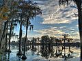
 Panoroma - panoramio.jpg 3,848 × 2,565; 5.43 MB
-
 Southern Trees - panoramio (1).jpg 3,356 × 2,502; 5.18 MB
-
 Southern Trees - panoramio.jpg 3,870 × 2,595; 6.74 MB
-
 Union Church Cemetery 01, Lanier County.JPG 4,320 × 3,240; 4.48 MB
-
 Union Church Cemetery 02, Lanier County.JPG 4,320 × 3,240; 4.45 MB
-
 Union Church Cemetery monument, Lanier County.JPG 4,320 × 3,240; 4.44 MB
-
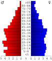 USA Lanier County, Georgia age pyramid.svg 520 × 600; 8 KB


.jpg)


