Category:Le Pouget (power station)
| Object location | | View all coordinates using: OpenStreetMap |
|---|
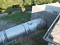
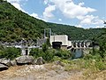
hydroelectric power station located at Le Truel, France  | |||||
| Upload media | |||||
| Instance of | |||||
|---|---|---|---|---|---|
| Location | Le Truel, canton of Saint-Rome-de-Tarn | ||||
| Operator | |||||
| Nominal power capacity |
| ||||
 | |||||
Media in category "Le Pouget (power station)"
The following 27 files are in this category, out of 27 total.
-
 EDF Pipes 5632.JPG 3,264 × 2,448; 3.69 MB
-
 EDF Pipes 5633.JPG 3,264 × 2,448; 3.68 MB
-
 EDF Pipes 5634.JPG 3,264 × 2,448; 3.62 MB
-
 FR-12-Pouget1.JPG 1,200 × 1,600; 375 KB
-
 FR-12-Pouget2.JPG 1,600 × 1,200; 421 KB
-
 La Romiguière 5474.JPG 3,264 × 2,448; 3.54 MB
-
 La Romiguière 5476.JPG 3,264 × 2,448; 3.52 MB
-
 La Romiguière 5484.JPG 3,264 × 2,448; 3.61 MB
-
 Le Pouget penstocks 5454.JPG 3,264 × 2,448; 3.38 MB
-
 Le Pouget penstocks 5455.JPG 3,264 × 2,448; 3.57 MB
-
 Le Pouget penstocks 5456.JPG 3,264 × 2,448; 3.26 MB
-
 Le Pouget penstocks 5457.JPG 3,264 × 2,448; 3.55 MB
-
 Le Pouget penstocks 5458.JPG 3,264 × 2,448; 3.45 MB
-
 Le Pouget penstocks 5459.JPG 3,264 × 2,448; 3.37 MB
-
 Le Pouget penstocks 5462.JPG 3,264 × 2,448; 3.61 MB
-
 Le Pouget penstocks 5465.JPG 3,264 × 2,448; 3.71 MB
-
 Le Pouget penstocks 5469.JPG 3,264 × 2,448; 3.61 MB
-
 Le Pouget penstocks 5471.JPG 3,264 × 2,448; 3.65 MB
-
 Le Pouget penstocks 5472.JPG 3,264 × 2,448; 3.35 MB
-
 Le Pouget penstocks 5481.JPG 2,448 × 3,264; 3.28 MB
-
 Le Pouget penstocks 5483.JPG 3,264 × 2,448; 3.64 MB
-
 Raspes de Tarn- Pont du Truel 5650.JPG 3,264 × 2,448; 3.63 MB
-
 Saint-Victor-et-Melvieu barrage Pouget (1).jpg 3,191 × 2,393; 2.17 MB
-
 Saint-Victor-et-Melvieu barrage Pouget (2).jpg 3,107 × 2,331; 2.17 MB
-
 St Amans 5610.JPG 3,264 × 2,448; 3.57 MB
-
 Tarn 5477.JPG 3,264 × 2,448; 3.49 MB
-
 Tarn 5480.JPG 3,264 × 2,448; 3.45 MB


.jpg)
.jpg)


