<nowiki>ruin Mülenen castle and Letzi; Burgruine Mülenen und Letzi; château de Mülenen; bene culturale svizzero d'importanza nazionale in Reichenbach im Kandertal; bien culturel suisse d'importance nationale à Reichenbach im Kandertal; Burg- und Wehrruine in Reichenbach im Kandertal im Kanton Bern, Schweiz; ruined castle and fortress in Reichenbach im Kandertal in the canton of Bern, Switzerland; قلعة في سويسرا; טירה בשווייץ; kasteel in Zwitserland; Ruine Burg Mülenen und Letzi; Burgeruine Mülenen und Letzi; Letzi Mülenen, Talsperre; Mulenen castle and Letzi; Letzi Mülenen, Talsperre</nowiki>
ruin Mülenen castle and Letzi
ruined castle and fortress in Reichenbach im Kandertal in the canton of Bern, Switzerland


 KGS Mülenen-Letzi-(10).JPG 2,560 × 1,920; 3.19 MB
 KGS Mülenen-Letzi-(15).JPG 1,920 × 2,560; 2.33 MB
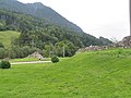 Letzi Mülenen1.JPG 3,648 × 2,736; 2.09 MB
 Letzi Mülenen2.JPG 3,648 × 2,736; 2.03 MB
 Mülenen Letzi 02.JPG 2,816 × 2,112; 3.15 MB
 Mülenen Letzi 03.JPG 2,112 × 2,816; 3.82 MB
 Mülenen Letzi 04.JPG 2,816 × 2,112; 3.61 MB
 Mülenen Letzi.JPG 2,816 × 2,112; 2.36 MB
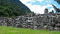 Reichenbach BE, Letzi Mülenen.jpg 1,920 × 1,080; 992 KB
.JPG)
.JPG)


