Category:Lexington Avenue/59th Street (New York City Subway)
New York City subway station  | |||||
| Upload media | |||||
| Instance of |
| ||||
|---|---|---|---|---|---|
| Named after | |||||
| Location | Manhattan, New York City, New York | ||||
| Transport network | |||||
| Operator | |||||
| Date of official opening |
| ||||
| Connecting line | |||||
| Adjacent station |
| ||||
| Different from | |||||
 | |||||
Subcategories
This category has the following 4 subcategories, out of 4 total.
5
B
- Blooming (artwork) (6 F)
Media in category "Lexington Avenue/59th Street (New York City Subway)"
The following 13 files are in this category, out of 13 total.
-
 59 Street entrance 2 vc.jpg 4,320 × 2,432; 3.1 MB
-
 59 Street entrance 3 vc.jpg 3,072 × 2,304; 3.43 MB
-
 59 Street entrance 4 vc.jpg 2,352 × 1,568; 2.68 MB
-
 59th Street Lexington Avenue Station Sign.jpg 2,048 × 1,536; 649 KB
-
 60th St Lex Av td 01 - 750 Lexington Avenue.jpg 5,472 × 3,648; 6.94 MB
-
 Bloomingdales, NYC (898056108).jpg 1,280 × 960; 599 KB
-
 E 60th St 3rd Av 01 - Ethan Allen.jpg 5,472 × 3,648; 7.2 MB
-
 E59th 3d Av stair jeh.JPG 2,924 × 1,956; 493 KB
-
 Lex Ave-59th Street Entrance.JPG 4,000 × 3,000; 2.85 MB
-
 Lexington 59 escalators vc.jpg 3,000 × 2,250; 6.49 MB
-
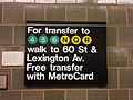
 Lexington 59 free transfer vc.jpg 3,002 × 4,500; 6.33 MB
-
 Lexington 63 free transfer vc.jpg 4,128 × 3,096; 4.76 MB
-
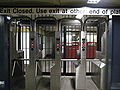 Lexington Avenue-59th Street New Turnstile.jpg 2,816 × 2,112; 4.09 MB


.jpg)


