Category:Linguistic maps of the Philippines
Subcategories
This category has only the following subcategory.
L
Media in category "Linguistic maps of the Philippines"
The following 88 files are in this category, out of 88 total.
-
 Philippine ethnic groups per province.PNG 1,883 × 3,120; 227 KB
-
 Adasen language map.png 2,000 × 3,120; 372 KB
-
 Aklanon language map.png 2,000 × 3,120; 414 KB
-
 Austronesian including Malay and various random languages.svg 754 × 580; 1.79 MB
-
 Austronesian languages.PNG 966 × 640; 315 KB
-
 Balangao language map.png 2,000 × 3,120; 371 KB
-
 Banao Itneg language map.png 2,000 × 3,120; 372 KB
-
 Bantoanon Language Map.png 2,000 × 3,120; 411 KB
-
 Batoanon language map.png 2,000 × 3,120; 371 KB
-
 Bikol languages map.png 2,000 × 3,120; 374 KB
-
 Bikol languages subdivision map.png 923 × 785; 112 KB
-
 Bikol languages.png 750 × 1,000; 45 KB
-
 Bikol Sentral language map.png 2,000 × 3,120; 353 KB
-
 Bilic languages.png 2,000 × 3,120; 353 KB
-
 Binukid language map.png 2,000 × 3,120; 373 KB
-
 Bisakol languages map.png 2,000 × 3,120; 372 KB
-
 Bontok language map.png 2,000 × 3,120; 372 KB
-
 Botolan Sambal language map.png 2,000 × 3,120; 372 KB
-
 Capiznon language map.png 2,000 × 3,120; 96 KB
-
 CapiznonLanguage.png 2,000 × 3,120; 197 KB
-
 Carte utilisation Hiligaïnon.png 220 × 343; 26 KB
-
 Map chavacano.gif 450 × 267; 5 KB
-
 Chavacano language map.png 2,000 × 3,120; 351 KB
-
 Dupangingan Agta language map.png 2,000 × 3,120; 373 KB
-
 Eight Major Languages of the Philippines.png 2,000 × 3,120; 330 KB
-
 Ethnolinguistic map of the Philippines.png 5,000 × 3,458; 781 KB
-
-
 Ga'dang language map.png 2,000 × 3,120; 372 KB
-
 Gaddang language map.png 2,000 × 3,120; 372 KB
-
 Greater Kankanaey language map.png 2,000 × 3,120; 373 KB
-
 Ibaloi language map.png 2,000 × 3,120; 372 KB
-
 Ibanag language map.png 2,000 × 3,120; 351 KB
-
 Ifugao dialect cluster map.png 2,000 × 3,120; 373 KB
-
 Ilocano language map.png 2,000 × 3,120; 352 KB
-
 Ilocanodistribution.jpg 600 × 900; 99 KB
-
 Ilokano language map.png 2,000 × 3,120; 394 KB
-
 Ilongot language map.png 2,000 × 3,120; 373 KB
-
 Inalod Itneg language map.png 2,000 × 3,120; 372 KB
-
 Inonhan language map.png 2,000 × 3,120; 371 KB
-
 Iranun language map.png 2,199 × 3,240; 423 KB
-
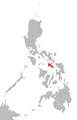
 Isinai language map.png 2,000 × 3,120; 372 KB
-
 Isnag language map.png 2,000 × 3,120; 373 KB
-
 Itawit language map.png 2,000 × 3,120; 372 KB
-
 Itneg dialect continuum map.png 2,000 × 3,120; 373 KB
-
 Ivatan language map.png 2,000 × 3,120; 405 KB
-
 Iwaak language map.png 2,000 × 3,120; 371 KB
-
 Kalinga dialect continuum map.png 2,000 × 3,120; 373 KB
-
 Kallahan language map.png 2,000 × 3,120; 372 KB
-
 Kapampagan cultural center.PNG 392 × 521; 31 KB
-
 Kapampangan language maximum extent.png 2,000 × 3,120; 393 KB
-
 Karao language map.png 2,000 × 3,120; 372 KB
-
 Kinaray-a language map.png 2,000 × 3,120; 418 KB
-
 KWF Linguistic Atlas of the Philippines (Overview).png 9,663 × 12,373; 13.96 MB
-
 Limos Kalinga language map.png 2,000 × 3,120; 372 KB
-
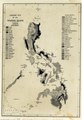
 Linguistic Map of the Philippines AD 1500.png 2,664 × 2,664; 192 KB
-
 Mabaka Valley Kalinga language map.png 2,000 × 3,120; 372 KB
-
 Maeng Itneg language map.png 2,000 × 3,120; 372 KB
-
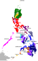
 Major Philippine languages.png 2,000 × 3,120; 395 KB
-
 Malayo-Polynesian (Smith 2017)-en.svg 729 × 521; 547 KB
-
 Manobo languages map.png 2,000 × 3,120; 377 KB
-
 Map of Hokaglish in the Philippines.png 1,396 × 2,291; 165 KB
-
 Map of the Major Languages of the Philippines.png 940 × 788; 193 KB
-
 Maranao language map.png 2,000 × 3,120; 352 KB
-
 Masbatenyo language map.png 2,000 × 3,120; 351 KB
-
 Northern Alta language map.png 2,000 × 3,120; 371 KB
-
 Northern Luzon languages.png 2,000 × 3,120; 357 KB
-
 Pahanan Agta language map.png 2,000 × 3,120; 372 KB
-
 Palawanic and Kalamian languages.png 432 × 410; 67 KB
-
 Pangasinan language map1.png 2,000 × 3,120; 355 KB
-
 Pangasinan language maximum extent.png 2,000 × 3,120; 440 KB
-
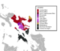
 Peoples of the Philippines en.svg 1,846 × 2,863; 332 KB
-
 Peoples of the Philippines no labels.svg 1,744 × 2,863; 110 KB
-
 Peoples of the Philippines ru.svg 1,811 × 2,863; 308 KB
-
 Philippine languages per region.png 2,000 × 3,120; 167 KB
-
 Phillanguages.jpg 600 × 900; 86 KB
-
 Remontado Dumagat language map.png 2,000 × 3,120; 348 KB
-
 Rinconada language map.png 2,000 × 3,120; 371 KB
-
 Romblomanon language map.png 2,000 × 3,120; 96 KB
-
 Sambal language map.png 2,000 × 3,120; 350 KB
-
 Southern Alta language map.png 2,000 × 3,120; 371 KB
-
 Southern Sinama language map.png 2,199 × 3,240; 361 KB
-
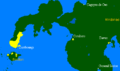
 Surigaonon and Tandaganon Language Map.png 457 × 528; 21 KB
-
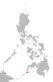
 Surigaonon language map.png 2,000 × 3,120; 351 KB
-
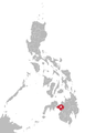
 Tagabawa language map.png 2,000 × 3,120; 371 KB
-
 The Batanic languages zh.png 798 × 800; 31 KB
-
 The Batanic languages.png 798 × 800; 14 KB
-
 Yakan language map.png 2,000 × 3,120; 350 KB
-
 Yogad language map.png 2,243 × 3,204; 417 KB


.png)


-en.svg)


