Category:Listullycurran

English: Listullycurran is a townland of 620 acres in the Electoral Division of Ballykeel, in Civil Parish of Dromore, in the Barony of Iveagh Lower, Lower Half, in the County of Down
Media in category "Listullycurran"
The following 7 files are in this category, out of 7 total.
-
 "No Dumping", Listullycurran - geograph.org.uk - 1451074.jpg 640 × 480; 64 KB
-

-
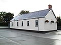 Listullycurran Orange Hall - geograph.org.uk - 1451014.jpg 640 × 480; 53 KB
-
 Listullycurran Railway Bridge - geograph.org.uk - 1451094.jpg 640 × 480; 102 KB
-
 Listullycurran Road, Dromore - geograph.org.uk - 1451064.jpg 640 × 480; 65 KB
-
 Old Railway Line at Listullycurran - geograph.org.uk - 1451052.jpg 640 × 480; 117 KB
-
 Overgrown Bridge at Listullycurran - geograph.org.uk - 1451088.jpg 640 × 480; 130 KB


