Category:Local election maps of Turkey
Countries of Asia: Turkey‡
‡: partly located in Asia
‡: partly located in Asia
Subcategories
This category has the following 8 subcategories, out of 8 total.
1
- 1963 Turkish local election maps (15 F)
- 1968 Turkish local election maps (46 F)
- 1999 Turkish local election maps (48 F)
2
- 2004 Turkish local election maps (86 F)
- 2009 Turkish local election maps (124 F)
- 2014 Turkish local election maps (118 F)
- 2019 Turkish local election maps (80 F)
- 2024 Turkish local election maps (43 F)
Media in category "Local election maps of Turkey"
The following 15 files are in this category, out of 15 total.
-
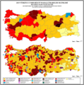
 1930 Türkiye Yerel Seçimleri.png 1,894 × 2,243; 230 KB
-
 1930 Yerel Seçimleri.png 1,920 × 1,080; 411 KB
-
 1950 Türkiye yerel seçimleri.png 1,894 × 2,243; 338 KB
-
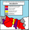 1973 TRABZON.png 1,046 × 1,084; 56 KB
-
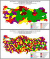
 1973 ys ap.png 1,829 × 1,077; 187 KB
-
 1977 ys.png 1,827 × 1,091; 167 KB
-
 1989 yerel seçimleri.png 1,280 × 879; 266 KB
-
 1994 CHP SHP DSP Birleşik.png 1,894 × 2,244; 291 KB
-
 1994 Mahalli İdareler Seçimleri BB.png 1,894 × 2,244; 335 KB
-
 1994 yerel seçim haritası.png 1,280 × 590; 130 KB
-
 1994 yerel seçimleri ilçe sonucu.png 1,280 × 879; 377 KB
-
 1994 yerel seçimleri sonucu.png 1,281 × 880; 104 KB
-
 2024 belediyee.png 1,894 × 1,906; 372 KB
-
 2024 Mahali İdareler Seçimleri (cropped).png 1,789 × 758; 253 KB
-
 2024 Mahali İdareler Seçimleri.png 1,897 × 2,246; 422 KB


.png)
