Category:Locator maps of autonomous communities of Spain (scheme 6)

|
All locator map images in this category could be re-created using vector graphics as SVG files. This has several advantages; see Commons:Media for cleanup for more information. If an SVG form of this image is available, please upload it and afterwards replace this template with
{{vector version available|new image name}}. |
Media in category "Locator maps of autonomous communities of Spain (scheme 6)"
The following 16 files are in this category, out of 16 total.
-
 Spain Andalucia.png 2,000 × 2,000; 136 KB
-
 Spain Aragon.png 2,000 × 2,000; 127 KB
-
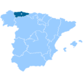 Spain Asturias.png 2,000 × 2,000; 136 KB
-
 Spain Balearic Islands.png 2,000 × 2,000; 136 KB
-
 Spain Basque.png 2,000 × 2,000; 134 KB
-
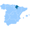
 Spain Cantabria.png 2,000 × 2,000; 135 KB
-
 Spain Y Leon.png 2,000 × 2,000; 123 KB
-
 Spain La Mancha.png 2,000 × 2,000; 122 KB
-
 Spain Catalonia.png 2,000 × 2,000; 134 KB
-
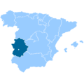 Spain Extremadura.png 2,000 × 2,000; 133 KB
-
 Spain Galicia.png 2,000 × 2,000; 136 KB
-
 Spain La Rioja.png 2,000 × 2,000; 134 KB
-
 Spain Madrid.png 2,000 × 2,000; 131 KB
-
 Spain Murcia.png 2,000 × 2,000; 133 KB
-
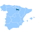
 Spain Navarre.png 2,000 × 2,000; 134 KB
-
 Spain Valencia.png 2,000 × 2,000; 131 KB


