Category:Locator maps of the Cook Islands
Subcategories
This category has the following 2 subcategories, out of 2 total.
!
*
Media in category "Locator maps of the Cook Islands"
The following 7 files are in this category, out of 7 total.
-
 Cook Islands - Location Map (2013) - COK - UNOCHA.svg 250 × 250; 1.2 MB
-
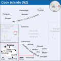
 LocationCookIslands.png 182 × 115; 6 KB
-
 Map of Cook Islands Federation 2.png 2,296 × 1,620; 92 KB
-
 Map of Cook Islands Federation 4.png 2,296 × 1,620; 86 KB
-
 Map of Kingdam of Rarotonga 2.png 2,296 × 1,620; 88 KB
-
 Map of Kingdam of Rarotonga 3.png 2,296 × 1,620; 86 KB
-
 Map of Rarotonga (1).png 2,296 × 1,620; 94 KB
_-_COK_-_UNOCHA.svg)


.png)