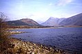
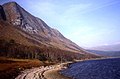
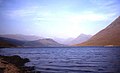
Category:Loch Etive

See Loch Etive
sea loch in Argyll and Bute, Scotland, UK  | |||||
| Upload media | |||||
| Instance of | |||||
|---|---|---|---|---|---|
| Location | Argyll and Bute, Scotland | ||||
| Located in or next to body of water | |||||
| Tributary | |||||
 | |||||
Subcategories
This category has the following 3 subcategories, out of 3 total.
A
- Ardmaddy Bay, Loch Etive (10 F)
C
- Connel Bridge (146 F)
Media in category "Loch Etive"
The following 200 files are in this category, out of 201 total.
(previous page) (next page)-
 "Reality" in Loch Etive - geograph.org.uk - 2519882.jpg 1,000 × 662; 225 KB
-
 'Triton Stromness' in Loch Etive - geograph.org.uk - 6243861.jpg 2,537 × 1,901; 2.07 MB
-

-
 2011 Argyllshire Loch Etive 27-05-2011 10-38-46.jpg 3,882 × 2,426; 1.56 MB
-
 2011 Argyllshire Loch Etive mobiele pier 27-05-2011 10-41-45.jpg 2,043 × 1,277; 429 KB
-
 2011-05 Schotland Loch Etive 27-05-2011 10-38-46.png 3,882 × 2,426; 12.58 MB
-
 2011-05 Schotland Loch Etive mobiele pier 27-05-2011 10-41-45.png 2,043 × 1,277; 3.8 MB
-
 341 of '(The Great Ice Age and its relation to the antiquity of man.)' (11120186515).jpg 2,256 × 1,380; 473 KB
-
 A quiet corner of the loch at Achnacloich.jpg 1,600 × 1,200; 466 KB
-
 A view of Loch Etive from the A82 - geograph.org.uk - 1350212.jpg 640 × 480; 39 KB
-
 A wreck at Loch Etive - geograph.org.uk - 2401745.jpg 640 × 429; 202 KB
-

-
 Admiralty Chart No 2814a Scotland west coast Loch Linnhe southern part, Published 1862, NLS.jpg 6,725 × 9,977; 18.95 MB
-
 Admiralty Chart No 2814b Lochs Etive and Creran, Published 1863, Composite.jpg 7,904 × 9,870; 23.36 MB
-
 Admiralty Chart No 2814b Lochs Etive and Creran, Published 1863.jpg 6,715 × 9,992; 32.8 MB
-
 Admiralty Chart No 3739 Loch Long torpedo range.jpg 4,520 × 6,878; 18.69 MB
-
 Admiralty Chart No 3739 Plans on the west coast of Scotland, Published 1968.jpg 16,389 × 11,250; 93.47 MB
-
 Airds Bay, Loch Etive. - geograph.org.uk - 1349700.jpg 640 × 480; 139 KB
-

-
 Bagh na Dalach - geograph.org.uk - 38187.jpg 640 × 415; 67 KB
-
 Beinn Eunaich , Munro No 156 - geograph.org.uk - 80044.jpg 640 × 480; 120 KB
-
 Ben Cruachan - geograph.org.uk - 1440625.jpg 640 × 418; 63 KB
-
 Boat anchored in Loch Etive - geograph.org.uk - 4712571.jpg 1,024 × 683; 971 KB
-
 Boat on Loch Etive - geograph.org.uk - 1707890.jpg 640 × 480; 84 KB
-
 Boats at mooring on Loch Etive. - geograph.org.uk - 195259.jpg 640 × 480; 95 KB
-
 Boats on Loch Etive - geograph.org.uk - 6243856.jpg 3,264 × 2,448; 3.12 MB
-
 Boisterous - geograph.org.uk - 2577186.jpg 1,250 × 828; 351 KB
-
 Bonawe Jetty - geograph.org.uk - 52762.jpg 640 × 427; 132 KB
-
 Bonawe Jetty, Loch Etive - geograph.org.uk - 1274650.jpg 640 × 480; 70 KB
-
 Boulder field, Beinn Maol Chaluim - geograph.org.uk - 815850.jpg 640 × 480; 303 KB
-
 Canoe in Glen Etive - geograph.org.uk - 2500207.jpg 1,000 × 635; 125 KB
-
 Connel, Argyll And Bute geograph-3488552-by-Ben-Brooksbank.jpg 1,183 × 750; 907 KB
-

-
 Creagan a' Mhoulaich - geograph.org.uk - 1459055.jpg 640 × 359; 65 KB
-
 Delta of River Kinglass - geograph.org.uk - 1396299.jpg 640 × 480; 111 KB
-
 Derelict boathouse near the head of Loch Etive - geograph.org.uk - 6714277.jpg 1,600 × 1,200; 764 KB
-
 Eastward up Glen Noe from Loch Etive - geograph.org.uk - 4767608.jpg 2,242 × 1,489; 2.66 MB
-
 Fenceline leading into Loch Etive - geograph.org.uk - 661717.jpg 640 × 480; 91 KB
-
 Fish Farm, Loch Etive - geograph.org.uk - 2407878.jpg 2,000 × 1,500; 391 KB
-
 Fish farming on Loch Ainort - geograph.org.uk - 2423376.jpg 640 × 480; 68 KB
-
 Fishermen on the Rubha nan Càrn - geograph.org.uk - 2550615.jpg 640 × 360; 65 KB
-
 Fishing boat in Loch Etive - geograph.org.uk - 2040312.jpg 1,600 × 1,200; 796 KB
-
 Fishing Lochan, Ardchattan - geograph.org.uk - 132523.jpg 640 × 480; 117 KB
-
 Foreshore, Loch Etive - geograph.org.uk - 91687.jpg 640 × 352; 55 KB
-
 Foreshore, Loch Etive, looking west - geograph.org.uk - 127858.jpg 640 × 480; 190 KB
-
 Glen Etive - Stob Dubh - geograph.org.uk - 1055.jpg 576 × 419; 36 KB
-
 Glen Etive Dusk - geograph.org.uk - 830695.jpg 640 × 480; 58 KB
-
 Glen Etive, Loch Etive estuary - geograph.org.uk - 3803780.jpg 4,608 × 3,456; 3.52 MB
-
 Glen Noe from Loch Etive - geograph.org.uk - 2040723.jpg 640 × 420; 126 KB
-
 Gorse at the head of Loch Etive - geograph.org.uk - 3477433.jpg 4,608 × 3,456; 5.26 MB
-
 Gorse Banks near Etive Estuary - geograph.org.uk - 2056538.jpg 640 × 480; 71 KB
-
 Head of Glen Etive - geograph.org.uk - 50506.jpg 640 × 430; 62 KB
-
 Head of Loch Etive - geograph.org.uk - 2040841.jpg 1,600 × 1,200; 697 KB
-
 Head of Loch Etive - geograph.org.uk - 2056522.jpg 640 × 480; 32 KB
-
 Head of Loch Etive - geograph.org.uk - 25037.jpg 640 × 480; 243 KB
-
 Head of Loch Etive - geograph.org.uk - 869483.jpg 640 × 447; 83 KB
-
 Head of Loch Etive. - geograph.org.uk - 2100703.jpg 3,017 × 1,920; 3.6 MB
-
 Head of the Loch - geograph.org.uk - 1333350.jpg 640 × 480; 51 KB
-
 Highlands - panoramio.jpg 4,288 × 2,848; 5.92 MB
-
 Ice-locked Etive - geograph.org.uk - 1800808.jpg 800 × 600; 117 KB
-
 Inverliver Bay and Ben Cruachan, from Loch Etive - geograph.org.uk - 4767634.jpg 2,388 × 1,576; 3.26 MB
-
 Jetty and boathouse, head of Loch Etive - geograph.org.uk - 1387694.jpg 640 × 426; 291 KB
-
 Jetty, Airds Bay - geograph.org.uk - 5559812.jpg 1,024 × 683; 315 KB
-
 Kilmaronag Islands, Loch Etive - geograph.org.uk - 4028811.jpg 640 × 480; 301 KB
-
 Kilmaronag Islands, Loch Etive - geograph.org.uk - 4712580.jpg 1,024 × 649; 118 KB
-
 Kilmaronag Islands, Loch Etive - geograph.org.uk - 5463213.jpg 1,600 × 1,200; 567 KB
-
 Linne na Craige, Loch Etive - geograph.org.uk - 6564220.jpg 1,024 × 768; 290 KB
-
 Loch Etive - geograph.org.uk - 107485.jpg 640 × 480; 141 KB
-
 Loch Etive - geograph.org.uk - 1080922.jpg 640 × 485; 68 KB
-
 Loch Etive - geograph.org.uk - 129329.jpg 640 × 480; 72 KB
-
 Loch Etive - geograph.org.uk - 1342043.jpg 640 × 427; 139 KB
-
 Loch Etive - geograph.org.uk - 1395748.jpg 640 × 480; 98 KB
-
 Loch Etive - geograph.org.uk - 17747.jpg 640 × 480; 56 KB
-
 Loch Etive - geograph.org.uk - 2040303.jpg 1,600 × 1,200; 774 KB
-
 Loch Etive - geograph.org.uk - 2040307.jpg 1,600 × 1,200; 876 KB
-
 Loch Etive - geograph.org.uk - 235709.jpg 640 × 480; 57 KB
-
 Loch Etive - geograph.org.uk - 2444442.jpg 640 × 480; 50 KB
-
 Loch Etive - geograph.org.uk - 3215026.jpg 640 × 344; 34 KB
-
 Loch Etive - geograph.org.uk - 3254579.jpg 1,600 × 1,200; 387 KB
-
 Loch Etive - geograph.org.uk - 3254584.jpg 1,600 × 1,200; 187 KB
-
 Loch Etive - geograph.org.uk - 3928464.jpg 640 × 485; 65 KB
-
 Loch Etive - geograph.org.uk - 4138485.jpg 1,600 × 1,063; 602 KB
-
 Loch Etive - geograph.org.uk - 4222341.jpg 1,600 × 1,067; 329 KB
-
 Loch Etive - geograph.org.uk - 4712584.jpg 2,560 × 1,920; 2.64 MB
-
 Loch Etive - geograph.org.uk - 4715315.jpg 4,320 × 2,432; 1.81 MB
-
 Loch Etive - geograph.org.uk - 473773.jpg 640 × 421; 62 KB
-
 Loch Etive - geograph.org.uk - 4955044.jpg 1,024 × 768; 306 KB
-
 Loch Etive - geograph.org.uk - 5560446.jpg 1,024 × 683; 253 KB
-
 Loch Etive - geograph.org.uk - 57999.jpg 640 × 480; 44 KB
-
 Loch Etive - geograph.org.uk - 6170452.jpg 3,264 × 2,448; 2.38 MB
-
 Loch Etive - geograph.org.uk - 717679.jpg 640 × 480; 36 KB
-
 Loch Etive 01.JPG 3,264 × 2,448; 1.24 MB
-
 Loch Etive 02.JPG 3,264 × 2,448; 1.23 MB
-
 Loch Etive 03.JPG 3,060 × 2,295; 3.95 MB
-
 Loch Etive and Ben Cruachan - geograph.org.uk - 6244265.jpg 3,264 × 2,448; 2.8 MB
-
 Loch Etive at Ardchattan House - geograph.org.uk - 6244262.jpg 3,264 × 2,448; 4.31 MB
-
 Loch Etive at Ardchattan House - geograph.org.uk - 6244288.jpg 3,264 × 2,448; 4.75 MB
-
 Loch Etive at sunset - geograph.org.uk - 1725605.jpg 3,648 × 2,736; 3.39 MB
-
 Loch Etive at White Croft - geograph.org.uk - 6244245.jpg 3,264 × 2,448; 4.63 MB
-
 Loch Etive by J. Merigot - James Mérigot - ABDAG011925.jpg 500 × 378; 26 KB
-
 Loch Etive by North Connel - geograph.org.uk - 1340816.jpg 640 × 427; 167 KB
-
 Loch Etive from Ben Starav - geograph.org.uk - 6479532.jpg 1,799 × 1,199; 309 KB
-
 Loch Etive from Bonawe Jetty looking NE - geograph.org.uk - 128593.jpg 640 × 480; 145 KB
-
 Loch Etive from Bonawe Slipway - geograph.org.uk - 52763.jpg 640 × 427; 137 KB
-
 Loch Etive from Connel Bridge - geograph.org.uk - 4317424.jpg 1,250 × 807; 643 KB
-
 Loch Etive from the Bonawe jetty. - geograph.org.uk - 1350299.jpg 640 × 480; 146 KB
-
 Loch Etive from the old Ferry Pier - geograph.org.uk - 960331.jpg 626 × 430; 72 KB
-

-
 Loch Etive Head - geograph.org.uk - 942717.jpg 640 × 426; 67 KB
-
 Loch Etive reflections - geograph.org.uk - 4172322.jpg 1,600 × 1,067; 307 KB
-
 Loch Etive roadside - geograph.org.uk - 6243016.jpg 3,264 × 2,448; 4.49 MB
-
 Loch Etive shore - geograph.org.uk - 6243845.jpg 3,264 × 2,448; 2.98 MB
-
 Loch Etive shore by Achnaba Lodge - geograph.org.uk - 6244247.jpg 3,264 × 2,448; 4.86 MB
-
 Loch Etive shore near Achnacreebeag - geograph.org.uk - 6245045.jpg 3,264 × 2,448; 3.23 MB
-
 Loch Etive shore, north side, at Achnacree - geograph.org.uk - 4252028.jpg 1,024 × 634; 186 KB
-
 Loch Etive shoreline - geograph.org.uk - 2040315.jpg 1,600 × 1,200; 733 KB
-
 Loch Etive shoreline - geograph.org.uk - 2393777.jpg 1,000 × 675; 274 KB
-
 Loch Etive shoreline at Eilean Traighe - geograph.org.uk - 2401741.jpg 416 × 640; 188 KB
-
 Loch Etive under a brooding sky - geograph.org.uk - 2530284.jpg 2,272 × 1,704; 1.17 MB
-
 Loch Etive View - geograph.org.uk - 3438986.jpg 640 × 396; 74 KB
-
 Loch Etive View - geograph.org.uk - 3439005.jpg 640 × 453; 83 KB
-
 Loch Etive View - geograph.org.uk - 3439010.jpg 640 × 450; 52 KB
-
 Loch Etive viewed from Ben Cruachan - geograph.org.uk - 178048.jpg 640 × 480; 45 KB
-
 Loch Etive, Argyllshire.jpg 925 × 1,200; 329 KB
-

-
 Loch Etive. Reflections.jpg 1,280 × 960; 227 KB
-
 Loch Etive.jpg 1,280 × 1,024; 271 KB
-

-
 Looking towards the old pier - geograph.org.uk - 2447558.jpg 640 × 480; 78 KB
-
 Lorn Quay and Kelly's Pier, Loch Etive, Taynuilt, Scotland.jpg 4,529 × 2,552; 3.76 MB
-
 Mouth of Allt Coire na Làrach - geograph.org.uk - 1387689.jpg 640 × 385; 233 KB
-
 NE up Loch Etive off Inverliver Bay - geograph.org.uk - 4767665.jpg 2,423 × 1,521; 2.97 MB
-
 New jetty at the head of Loch Etive - geograph.org.uk - 1582085.jpg 640 × 480; 93 KB
-
 New pier, Loch Etive - geograph.org.uk - 1316274.jpg 640 × 427; 259 KB
-
 Oban Dunstaffnage Bay and Loch Etive seen from Connel 1.jpg 6,000 × 4,000; 11.8 MB
-
 Oban Dunstaffnage Bay and Loch Etive seen from Connel 2.jpg 6,000 × 4,000; 11.51 MB
-
 Oban North Connel Houses on Bonawe Road seen from the other bank of Loch Etive.jpg 6,000 × 4,000; 12.01 MB
-
 Old Jetty, Loch Etive - geograph.org.uk - 1202890.jpg 640 × 415; 46 KB
-
 Old Jetty, Loch Etive - geograph.org.uk - 869666.jpg 477 × 640; 98 KB
-
 Old pier just NE of Rubha na h-Oisinne - geograph.org.uk - 4772543.jpg 1,920 × 1,082; 772 KB
-
 Old pier, and the new jetty, Loch Etive - geograph.org.uk - 1387711.jpg 640 × 426; 414 KB
-

-
 Ordnance Survey One-Inch Sheet 46 Loch Linnhe, Published 1956 2.jpg 8,630 × 10,690; 16.01 MB
-
 Ordnance Survey One-Inch Sheet 46 Loch Linnhe, Published 1956.jpg 8,231 × 9,873; 11.27 MB
-
 Ordnance Survey One-Inch Sheet 54 Loch Etive & Glen Coe, Published 1947.jpg 12,202 × 9,336; 13.22 MB
-
 Pocket beach on Loch Etive south shore - geograph.org.uk - 4238063.jpg 4,288 × 2,387; 2.78 MB
-
 Port an Dòbhrain - geograph.org.uk - 4954992.jpg 1,024 × 768; 305 KB
-
 Port Ban - geograph.org.uk - 38192.jpg 640 × 418; 88 KB
-
 Ripples on Loch Etive - geograph.org.uk - 1340835.jpg 640 × 427; 176 KB
-
 River Awe, Loch Etive - geograph.org.uk - 1355459.jpg 640 × 480; 184 KB
-

-
 Rubha na Staing - Loch Etive - geograph.org.uk - 235716.jpg 640 × 426; 47 KB
-
 Ruined Jetty, Loch Etive - geograph.org.uk - 25041.jpg 480 × 640; 250 KB
-
 Rusty old shed - geograph.org.uk - 1333337.jpg 640 × 480; 129 KB
-
 Sgeirean Inverliver, Loch Etive - geograph.org.uk - 2040695.jpg 640 × 425; 116 KB
-
 Sgeirean Inverliver, Loch Etive - geograph.org.uk - 2040707.jpg 640 × 425; 166 KB
-
 Ship on Loch Etive - geograph.org.uk - 3346625.jpg 1,024 × 672; 485 KB
-
 Shore of Loch Etive - geograph.org.uk - 3611999.jpg 1,200 × 781; 672 KB
-
 Shore of Loch Etive near Glen Noe - geograph.org.uk - 3612011.jpg 1,200 × 800; 521 KB
-
 Shoreline of Loch Etive - geograph.org.uk - 3211558.jpg 1,200 × 797; 431 KB
-
 Small bay on Loch Etive - geograph.org.uk - 1707740.jpg 640 × 480; 83 KB
-
 Small bay on Loch Etive - geograph.org.uk - 3691116.jpg 640 × 481; 78 KB
-
 Small island in a bay at Loch Etive - geograph.org.uk - 3691126.jpg 640 × 481; 89 KB
-
 Small island in Loch Etive - geograph.org.uk - 6243835.jpg 3,264 × 2,448; 2.72 MB
-
 Small island on a bay in Loch Etive - geograph.org.uk - 1976637.jpg 3,648 × 2,736; 2.09 MB
-
 Small island on a bay in Loch Etive - geograph.org.uk - 1976643.jpg 3,648 × 2,736; 2.13 MB
-
 Small jetty at Ardchattan Loch Etive - geograph.org.uk - 1976679.jpg 3,648 × 2,736; 2.1 MB
-
 Small reef in Loch Etive - geograph.org.uk - 6243858.jpg 3,264 × 2,448; 3.03 MB
-
 Submersible Kilmaronag Island - geograph.org.uk - 5339130.jpg 1,600 × 1,076; 224 KB
-
 The Connel Bridge.jpg 5,616 × 3,744; 7.49 MB
-
 The mouth of the River Etive entering Loch Etive - geograph.org.uk - 6479527.jpg 1,799 × 1,199; 377 KB
-
 Tide race, Loch Etive - geograph.org.uk - 738988.jpg 640 × 480; 68 KB
-
 Triton in Loch Etive - geograph.org.uk - 4080175.jpg 3,372 × 2,698; 1.46 MB
-
 View North up Loch Etive - geograph.org.uk - 3830855.jpg 640 × 480; 93 KB
-
 View of Ben Cruachan from Ardchattan - geograph.org.uk - 107792.jpg 640 × 480; 41 KB
-
 View of Loch Etive.jpg 1,280 × 1,024; 508 KB
-
 View over Loch Etive towards Ben Chruachan - geograph.org.uk - 1748296.jpg 1,024 × 683; 138 KB
-
 View south west from Stob na Broige - geograph.org.uk - 900905.jpg 800 × 498; 131 KB
-
 View southwest from Stob Dubh - geograph.org.uk - 711798.jpg 1,000 × 665; 181 KB
-
 Winter light at the head of Loch Etive - geograph.org.uk - 3477122.jpg 1,024 × 620; 102 KB
-
 Dunstaffnage Bay - geograph.org.uk - 13687.jpg 640 × 409; 158 KB
-
 Foreshore Loch Etive - geograph.org.uk - 121465.jpg 640 × 480; 89 KB
-
 Foreshore, Loch Etive - geograph.org.uk - 91683.jpg 640 × 480; 81 KB
-
 Head of Loch Etive - geograph.org.uk - 473784.jpg 640 × 423; 59 KB
-
 Inveresregan - geograph.org.uk - 132502.jpg 640 × 480; 116 KB
-
 Inverliver Bay Loch Etive - geograph.org.uk - 115984.jpg 640 × 419; 72 KB
-
 Islands, Loch Etive - geograph.org.uk - 91685.jpg 640 × 480; 45 KB
-
 Loch Etive - geograph.org.uk - 286079.jpg 640 × 431; 67 KB
-
 Loch Etive - geograph.org.uk - 290864.jpg 640 × 480; 28 KB
-
 Loch Etive - geograph.org.uk - 501249.jpg 640 × 480; 63 KB
-
 Loch Etive - geograph.org.uk - 662385.jpg 640 × 427; 34 KB
-
 Loch Etive and Airds Park - geograph.org.uk - 132532.jpg 640 × 480; 56 KB
-
 Loch Etive from Baile Mhaodain Church - geograph.org.uk - 132494.jpg 480 × 640; 138 KB
-
 Loch Etive from Meall nan Each - geograph.org.uk - 10001.jpg 640 × 434; 49 KB
-
 North shore of Loch Etive - geograph.org.uk - 473779.jpg 640 × 421; 57 KB
-
 Northern end of Loch Etive - geograph.org.uk - 473821.jpg 640 × 392; 40 KB
-
 Zonder titel PK-F-66.611, PK-F-66.610.jpg 1,772 × 1,179; 550 KB
-
 River Awe meets Loch Etive. - geograph.org.uk - 73276.jpg 640 × 480; 128 KB
-

-
 Towards Loch Etive - geograph.org.uk - 702678.jpg 500 × 332; 198 KB


.jpg)


%27_(11120186515).jpg)


_Cropped_from_Admiralty_Chart_No_2814a_Scotland_west_coast_Loch_Linnhe_southern_part,_Published_1862,_NLS.jpg)