Category:Lohrheidestadion
| Object location | | View all coordinates using: OpenStreetMap |
|---|
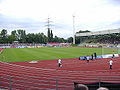
football stadium  | |||||
| Upload media | |||||
| Instance of | |||||
|---|---|---|---|---|---|
| Location | Bochum, Arnsberg Government Region, North Rhine-Westphalia, Germany | ||||
| Occupant | |||||
| Inception |
| ||||
| Date of official opening |
| ||||
| Maximum capacity |
| ||||
 | |||||
Media in category "Lohrheidestadion"
The following 4 files are in this category, out of 4 total.
-
 Bochum - Lohrheidestadion + Zeche Holland Schacht 4 (Halde Rheinelbe Süd) 01 ies.jpg 5,616 × 3,744; 11.42 MB
-
 Bochum - Lohrheidestadion + Zeche Holland Schacht 4 (Halde Rheinelbe Süd) 02 ies.jpg 5,616 × 3,744; 14.07 MB
-
 Lohrheidestadion Wattenscheid.jpg 2,592 × 1,944; 2.63 MB
-
 Lohrheidestadion.jpg 1,360 × 1,024; 745 KB
_01_ies.jpg)
_02_ies.jpg)
