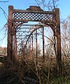
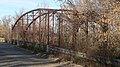
Category:Long Shoals bridge (Bourbon County, Kansas)
|
This is a category about a place or building that is listed on the National Register of Historic Places in the United States of America. Its reference number is 89002182. |
| Object location | | View all coordinates using: OpenStreetMap |
|---|
road bridge  | |||||
| Upload media | |||||
| Instance of | |||||
|---|---|---|---|---|---|
| Location | Bourbon County, Kansas | ||||
| Crosses |
| ||||
| Heritage designation |
| ||||
| Inception |
| ||||
| Length |
| ||||
 | |||||
Media in category "Long Shoals bridge (Bourbon County, Kansas)"
The following 8 files are in this category, out of 8 total.
-
 Long Shoals bridge from NW 1.jpg 2,559 × 1,364; 1.31 MB
-
 Long Shoals bridge from S 1.jpg 1,819 × 2,182; 1.28 MB
-
 Long Shoals bridge from S 2.jpg 1,859 × 2,479; 1.26 MB
-
 Long Shoals bridge from SW 1.jpg 2,066 × 1,157; 902 KB
-
 Long Shoals bridge from SW 2.jpg 2,322 × 1,227; 1,006 KB
-
 Long Shoals bridge N end 1.jpg 2,175 × 1,919; 1.61 MB
-
 Long Shoals bridge S end 1.jpg 1,645 × 2,247; 1.34 MB
-
 Long Shoals bridge S end plaque 1.jpg 2,490 × 1,460; 788 KB


