Category:Longridge Fell
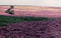
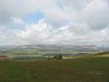
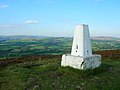
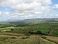
English: Longridge Fell is a fell near the English town of Longridge, Lancashire. It lies within the Forest of Bowland Area of Outstanding Natural Beauty. As its name suggests, it takes the form of a long ridge which rises in a northeasterly direction from the town of Longridge to its summit 4.5 miles distant. As the ridge curves towards the east, it comes to a sudden end and drops into the Hodder valley. The fell is a good example of a cuesta; the ridge has a sharp drop or escarpment on its northern side, and a gentler slope on its southern side. These features make it a popular takeoff for hang-gliders and paragliders on the relatively infrequent occurrences of a northerly wind. (→Longridge Fell)

mountain in United Kingdom | |||||
| Upload media | |||||
| Instance of | |||||
|---|---|---|---|---|---|
| Location |
| ||||
| Topographic prominence |
| ||||
| Elevation above sea level |
| ||||
| Parent peak | |||||
 | |||||
Media in category "Longridge Fell"
The following 31 files are in this category, out of 31 total.
-
 Longridge Fell (Loud Valley).jpg 640 × 480; 61 KB
-
 Longridge Fell 229-03.jpg 1,321 × 265; 80 KB
-
 Longridge Fell and Pendle Hill May 2007 229-34.jpg 1,569 × 321; 162 KB
-
 Longridge Fell, Lancashire.jpg 640 × 402; 60 KB
-
 Longridge Fell.jpg 1,024 × 768; 257 KB
-
 Longridge Fell2.jpg 1,024 × 768; 208 KB
-
 Longridge Golf Course Clubhouse.jpg 640 × 426; 113 KB
-
 Longridge.jpg 424 × 71; 9 KB
-
 Oak Barn, off Birks Brow - geograph.org.uk - 102618.jpg 640 × 426; 131 KB
-
 Pendle Hill above mist 235-0004.jpg 1,801 × 641; 350 KB
-
 Trig Point.jpg 640 × 480; 97 KB
-
 View from Parlick - geograph.org.uk - 542133.jpg 640 × 480; 72 KB
-
 Bog Cotton and grass on Longridge Fell - geograph.org.uk - 7952.jpg 640 × 480; 169 KB
-
 Cairn, Longridge Fell - geograph.org.uk - 700982.jpg 640 × 480; 55 KB
-
 Cardwell House at Jeffery Hill - geograph.org.uk - 348837.jpg 640 × 425; 201 KB
-
 Copster Green - geograph.org.uk - 97800.jpg 640 × 427; 120 KB
-
 Dilworth Upper Reservoir - geograph.org.uk - 574245.jpg 640 × 480; 142 KB
-
 Forest Fire Road, Longridge Fell - geograph.org.uk - 88930.jpg 640 × 480; 131 KB
-
 From Cold Coats Hall toward Longridge Fell - geograph.org.uk - 58957.jpg 640 × 427; 123 KB
-

-
 Green Thorn Farm, Longridge Fell - geograph.org.uk - 88920.jpg 640 × 445; 106 KB
-
 Leaving Longridge Fell - geograph.org.uk - 88926.jpg 640 × 447; 105 KB
-
 Longridge Fell - geograph.org.uk - 7950.jpg 640 × 480; 126 KB
-
 Longridge Fell from Gt Mitton - geograph.org.uk - 72297.jpg 640 × 480; 98 KB
-
 Longridge Reservoir - geograph.org.uk - 84115.jpg 640 × 480; 127 KB
-
 New Hedge - geograph.org.uk - 119089.jpg 640 × 426; 150 KB
-
 Road junction top of Jeffery Hill - geograph.org.uk - 102604.jpg 640 × 426; 143 KB
-
 Road to Jeffrey Hill - geograph.org.uk - 341124.jpg 640 × 480; 54 KB
-
 Summit of Longridge Fell - geograph.org.uk - 449847.jpg 640 × 400; 264 KB
-
 The road to Brick House Farm - geograph.org.uk - 158521.jpg 640 × 480; 95 KB
-
 View from the Spread Eagle. - geograph.org.uk - 42501.jpg 640 × 427; 111 KB
.jpg)


