Category:Lynnwood High School (Lynnwood, Washington)
| Object location | | View all coordinates using: OpenStreetMap |
|---|
high school in Washington, United States  | |||||
| Upload media | |||||
| Instance of | |||||
|---|---|---|---|---|---|
| Location | Washington, Pacific Northwest, Washington, Pacific States Region | ||||
| School district |
| ||||
| Inception |
| ||||
 | |||||
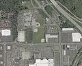
English: The old Lynnwood High School was on the north side of Alderwood Mall in the city of Lynnwood, Washington. It opened in 1970 and closed in June 2009, replaced by the new Lynnwood High School to the east in Bothell.
Media in category "Lynnwood High School (Lynnwood, Washington)"
The following 3 files are in this category, out of 3 total.
-
 Lhs(aerialview).jpg 1,000 × 800; 157 KB
-
 Lynnwood High - Courtyard.jpg 1,024 × 768; 480 KB
-
 Lynnwood high school.jpg 3,264 × 2,448; 714 KB
.jpg)

