Category:Mühlbühl-Ponordoline
| Object location | | View all coordinates using: OpenStreetMap |
|---|
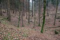
Deutsch: Die Mühlbühl-Ponordoline im Veldensteiner Forst westlich der Gemeinde Königstein im Landkreis Amberg-Sulzbach in Bayern, Deutschland ist eine größere Doline, in die zeitweise das Wasser eines kleinen Baches einläuft.
Media in category "Mühlbühl-Ponordoline"
The following 16 files are in this category, out of 16 total.
-
 Mühlbühl-Ponor 01.jpg 11,964 × 5,244; 54.91 MB
-
 Mühlbühl-Ponor 02.jpg 5,472 × 3,648; 20.07 MB
-
 Mühlbühl-Ponor 03.jpg 5,472 × 3,648; 19.39 MB
-
 Mühlbühl-Ponor 04.jpg 5,472 × 3,648; 22.32 MB
-
 Mühlbühl-Ponor 05.jpg 5,472 × 3,648; 20.49 MB
-
 Mühlbühl-Ponor 06.jpg 5,472 × 3,648; 20.13 MB
-
 Mühlbühl-Ponor 07.jpg 5,472 × 3,648; 19.91 MB
-
 Mühlbühl-Ponor 08.jpg 5,472 × 3,648; 17.92 MB
-
 Mühlbühl-Ponor 09.jpg 5,472 × 3,648; 17.77 MB
-
 Mühlbühl-Ponor 10.jpg 5,472 × 3,648; 19.11 MB
-
 Mühlbühl-Ponor 11.jpg 3,648 × 5,472; 18.33 MB
-
 Mühlbühl-Ponor 12.jpg 5,472 × 3,648; 17.12 MB
-
 Mühlbühl-Ponor 13.jpg 5,472 × 3,648; 18.63 MB
-
 Mühlbühl-Ponor 14.jpg 5,472 × 3,648; 15.19 MB
-
 Mühlbühl-Ponor 15.jpg 5,472 × 3,648; 15.82 MB
-
 Ponor Hersbrucker-Alb Fraenkische-Alb.jpg 1,800 × 1,200; 2.24 MB


