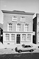
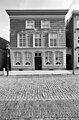
Category:Maasstraat 15, Grave
| Object location | | View all coordinates using: OpenStreetMap |
|---|
house in Grave, Netherlands  | |||||
| Upload media | |||||
| Instance of | |||||
|---|---|---|---|---|---|
| Location | Grave, Land van Cuijk, North Brabant, Netherlands | ||||
| Street address |
| ||||
| Located on street | |||||
| Heritage designation |
| ||||
 | |||||
|
This is a category about rijksmonument number 17272
|
| Address |
|
Media in category "Maasstraat 15, Grave"
The following 6 files are in this category, out of 6 total.
-
 5361 Grave, Netherlands - panoramio (36).jpg 2,048 × 1,155; 572 KB
-
 Grave - Maasstraat 15.jpg 1,944 × 2,592; 1.17 MB
-
 Overzicht - Grave - 20084126 - RCE.jpg 948 × 1,200; 238 KB
-
 Overzicht oneven - Grave - 20084116 - RCE.jpg 1,200 × 788; 230 KB
-
 Voorgevel - Grave - 20084130 - RCE.jpg 801 × 1,200; 181 KB
-
 Voorgevel - Grave - 20084131 - RCE.jpg 788 × 1,200; 243 KB
.jpg)


