Category:Magnetic field maps of the world
| Upload media | |||||
| Subclass of |
| ||||
|---|---|---|---|---|---|
| Depicts | Q1418982 | ||||
| |||||
Subcategories
This category has the following 2 subcategories, out of 2 total.
Media in category "Magnetic field maps of the world"
The following 88 files are in this category, out of 88 total.
-

-

-

-
 Total Magnetic Field for 2000.jpg 750 × 500; 423 KB
-
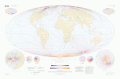
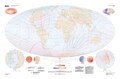
 WMM2010 F MERC.jpg 3,254 × 2,176; 3.24 MB
-
 WMM2010 F MERC.pdf 5,400 × 3,600; 866 KB
-
 June 2014 magnetic field.jpg 6,000 × 4,800; 1.65 MB
-
-

-

-
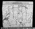
 Admiralty Chart No 1803 Cabo do Norte to Sao Luis, Published 1852, Large Corrections 1954.jpg 10,998 × 8,065; 26.07 MB
-
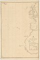 Admiralty Chart No 2060 North Atlantic Ocean, Eastern Part, Published 1851.jpg 8,130 × 12,018; 16.31 MB
-

-

-
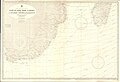
 Admiralty Chart No 2710 Delaware Bay to Florida Strait, published 1924, Large Corrections 1933.jpg 11,127 × 19,495; 54.63 MB
-
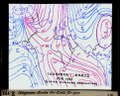
 Admiralty Chart No 5374 The World Curves of Equal Magnetic Variation, Published 1960.jpg 16,273 × 11,106; 54.45 MB
-
 Admiralty Chart No 5381 Curves of East Magnetic Intensity 1965.jpg 16,346 × 11,267; 38.11 MB
-
 Admiralty Chart No 596 Cape of Good Hope to Beira, Published 1935, Large Corrections 1960.jpg 16,297 × 11,071; 44.07 MB
-

-

-
 Brockhaus and Efron Encyclopedic Dictionary b23 479-1.jpg 1,730 × 2,684; 1.56 MB
-
 Brockhaus and Efron Encyclopedic Dictionary b23 479-2.jpg 1,511 × 2,730; 1.96 MB
-
 D map mf 2005 large.jpeg 720 × 480; 209 KB
-
 D map sv 2005 large.jpeg 720 × 480; 204 KB
-
 Deklináció.jpg 1,124 × 689; 232 KB
-
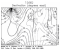 Earth Magnetic Field Declination from 1590 to 1990.gif 351 × 293; 3.25 MB
-
 El desvío de la aguja náutica 1875 Terry y Rivas 02.jpg 1,793 × 1,435; 311 KB
-
 ETH-BIB-Deklinationskarte der Schweiz 1948-Dia 247-F-00959.tif 3,600 × 2,968; 10.32 MB
-
 ETH-BIB-Isogonen in geolog. Schweizerkarte-Dia 247-Z-00196.tif 3,600 × 2,891; 29.93 MB
-
 ETH-BIB-Isogonen-Karte der Erde für 1900-Dia 247-Z-00193.tif 3,648 × 2,915; 30.54 MB
-
 F map mf 2005 large.jpeg 960 × 640; 397 KB
-
 F map sv 2005 large.jpeg 720 × 480; 216 KB
-
 FMIB 43939 Isodynamic Lines.jpeg 891 × 590; 183 KB
-
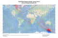
Global ocean magnetic field at sea level.webm 31 s, 1,920 × 1,080; 12.37 MB
-
 Grl63241-fig-0001-m.webp 2,128 × 2,927; 2.75 MB
-
 I map mf 2005 large.jpeg 960 × 640; 389 KB
-
 I map sv 2005 large.jpeg 720 × 480; 163 KB
-
 IGRF 2000 magnetic declination.gif 1,010 × 804; 66 KB
-
 Inklinationskarte fuer 1860.jpg 706 × 407; 95 KB
-
 Karte Deklination MKL1888.png 722 × 416; 82 KB
-
 Leonhard Euler World Map AD1760.jpg 2,615 × 2,252; 2.79 MB
-
 Lithosphere magnetism lrg.jpg 2,427 × 1,553; 916 KB
-
 Látszólagos pólusvándorlás.jpg 632 × 587; 105 KB
-
 Magnetic Declination and Inclination, 1885.pdf 1,650 × 1,275; 5.68 MB
-
-
 Magnetic Declination Chart for the International Geomagnetic Reference Field, 2005.pdf 8,204 × 5,400; 2.32 MB
-
 Magnetic Declination Chart for the International Geomagnetic Reference Field, 2005.png 15,448 × 10,167; 73.04 MB
-
 Magnetic Field Earth.png 568 × 291; 308 KB
-

-
 Magnetic Horizontal Intensity North Hemisphere 2000.png 729 × 728; 266 KB
-
 Magnetic Inclination Chart for the International Geomagnetic Reference Field, 2005.pdf 8,204 × 5,400; 1.98 MB
-
 Magnetic Storm Oct 2003.jpg 500 × 441; 59 KB
-
 Magnetic Total Intensity Chart for the International Geomagnetic Reference Field, 2005.pdf 8,204 × 5,400; 2.08 MB
-

-
 Map b field evolution.gif 630 × 420; 1.85 MB
-
 Meyers b11 s0085 b3.png 741 × 439; 132 KB
-
 Meyers b11 s0087 b1.png 738 × 439; 128 KB
-
 Meyers b11 s0087 b2.png 738 × 437; 128 KB
-
 Meyers b11 s0087.jpg 800 × 1,275; 332 KB
-
 Meyers b11 s0088 b1.png 737 × 440; 129 KB
-
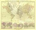
 Mv-world.jpg 5,700 × 4,200; 4.77 MB
-
 Neumayer Atlas des Erdmagnetismus 1.jpg 1,180 × 997; 459 KB
-
 Neumayer Atlas des Erdmagnetismus 1.pdf 2,458 × 2,077; 4.19 MB
-
 Neumayer Atlas des Erdmagnetismus 2.jpg 1,180 × 997; 417 KB
-
 Neumayer Atlas des Erdmagnetismus 2.pdf 2,458 × 2,077; 3.71 MB
-
 Neumayer Atlas des Erdmagnetismus 3.jpg 1,180 × 997; 370 KB
-
 Neumayer Atlas des Erdmagnetismus 3.pdf 2,458 × 2,077; 3.6 MB
-
 Neumayer Atlas des Erdmagnetismus 4.jpg 1,180 × 997; 407 KB
-
 Neumayer Atlas des Erdmagnetismus 4.pdf 2,458 × 2,077; 3.83 MB
-
 Neumayer Atlas des Erdmagnetismus 5.jpg 1,180 × 997; 364 KB
-
 Neumayer Atlas des Erdmagnetismus 5.pdf 2,458 × 2,077; 3.27 MB
-
 PSM V34 D305 The earth a magnet.jpg 1,523 × 1,555; 284 KB
-
 Systeme magnetique terrestre.jpg 5,965 × 3,835; 3.91 MB
-
 The Earth's Magnetism AdmiraltyNavigationManualVol1 0296.jpg 2,792 × 1,757; 1.32 MB
-
 World Magnetic Declination (Annual changes 2015).pdf 5,400 × 3,600; 1.55 MB
-
 World Magnetic Declination 2010.pdf 5,400 × 3,600; 865 KB
-
 World Magnetic Declination 2015.pdf 5,400 × 3,600; 1.57 MB
-
 World Magnetic Declination Map 2005.png 818 × 458; 226 KB
-
 World Magnetic Field (Annual changes 2015).pdf 5,400 × 3,600; 1.59 MB
-
 World Magnetic Field 2015.pdf 5,400 × 3,600; 1.59 MB
-
 World Magnetic Inclination (Annual changes) 2015.pdf 5,400 × 3,600; 1.52 MB
-
 World Magnetic Inclination 2010.pdf 5,400 × 3,600; 828 KB
-
 World Magnetic Inclination 2015.pdf 5,400 × 3,600; 1.55 MB
-
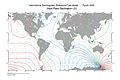
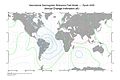
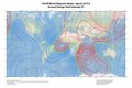
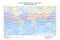
 World Magnetic Model Main Field Declination D 2010.png 2,883 × 2,037; 1.2 MB
-
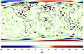
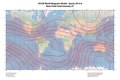
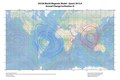
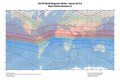
 World Magnetic Model Main Field Total Intensity F 2010.png 2,916 × 2,016; 1.62 MB
-
 Worldmagneticchart.png 1,952 × 1,318; 382 KB
-
 Worldmagneticcharttot.png 1,461 × 1,012; 245 KB
-
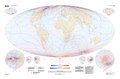
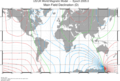
 WMM2010 D MERC.png 5,400 × 3,601; 13.03 MB
%27_(11246003815).jpg)
%27_(11245781736).jpg)


%27_(11035864915).jpg)
%27_(11046467424).jpg)


_(18409756346).jpg)
_(18437903361).jpg)


.gif)


