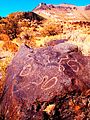
Category:Malheur County, Oregon
Counties of Oregon: Baker · Benton · Clackamas · Clatsop · Columbia · Coos · Crook · Curry · Deschutes · Douglas · Gilliam · Grant · Harney · Hood River · Jackson · Jefferson · Josephine · Klamath · Lake · Lane · Lincoln · Linn · Malheur · Marion · Morrow · Multnomah · Polk · Sherman · Tillamook · Umatilla · Union · Wallowa · Wasco · Washington · Wheeler · Yamhill
county in Oregon, United States   | |||||
| Upload media | |||||
| Instance of | |||||
|---|---|---|---|---|---|
| Named after | |||||
| Location | Oregon | ||||
| Capital | |||||
| Inception |
| ||||
| Population |
| ||||
| Area |
| ||||
| official website | |||||
 | |||||
Subcategories
This category has the following 33 subcategories, out of 33 total.
*
- Maps of Malheur County, Oregon (12 F)
2
A
- Adrian, Oregon (4 F)
- Agency Valley Dam (6 F)
B
- Brogan, Oregon (5 F)
- Bully Creek Dam (4 F)
C
D
H
- Harper, Oregon (1 F)
I
- Interstate 80N in Oregon (1 F)
J
- Juntura, Oregon (9 F)
M
- Malheur Enterprise (5 F)
- Minerals of Owyhee Dam (14 F)
N
O
P
R
- Rome, Oregon (2 F)
S
- Signs in Malheur County, Oregon (10 F)
V
- Vale Project Lateral 278 (2 F)
W
- Warm Springs Reservoir (10 F)
Media in category "Malheur County, Oregon"
The following 87 files are in this category, out of 87 total.
-
 1441 cougar wolfer odfw (14610353388).jpg 2,100 × 1,500; 2.93 MB
-
 1442 cougar wolfer odfw (14773986976).jpg 2,100 × 1,500; 2.94 MB
-
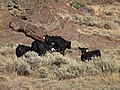 2012, Cows and Calves in Oregon's High Desert - panoramio (1).jpg 4,320 × 3,240; 5.51 MB
-
 2012, Cows and Calves in Oregon's High Desert - panoramio.jpg 4,320 × 3,240; 5.32 MB
-
 2012, Quinn River Valley, Nevada - panoramio.jpg 4,320 × 3,240; 5.49 MB
-
-
 2012, View South to Nevada's Quinn River Valley, from Malheur County Oregon - panoramio.jpg 4,320 × 3,240; 5.58 MB
-
 An Oregon Basalt Butte, Pic by Alex Dave, 2012 - panoramio.jpg 1,200 × 1,600; 409 KB
-
 An Oregon Basalt Flow, Pic by Alex Dave, 2012 - panoramio.jpg 1,200 × 1,600; 353 KB
-
 Annex Oregon.jpg 5,186 × 3,047; 9.7 MB
-
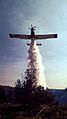
 Approaching flames (7557041238).jpg 640 × 480; 129 KB
-
-
 Basque Station (7544497554).jpg 640 × 480; 65 KB
-
 Basque Station (7556822578).jpg 4,000 × 3,000; 2.69 MB
-
-
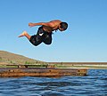 BoyDiving.jpg 718 × 645; 120 KB
-
 Burns junction oregon.jpg 4,128 × 2,705; 7.25 MB
-
 Camp Henderson Locale.jpg 2,000 × 768; 462 KB
-
 Charbonneau Headstone.jpg 3,024 × 4,032; 5.34 MB
-
 Charbonneau Story Sign.jpg 3,024 × 4,032; 3.93 MB
-
 Disaster Peak Nevada, Blain Davis, Photographer, 2012 - panoramio.jpg 4,320 × 3,240; 4.64 MB
-
 Eastern Oregon bobcats (30065075853).jpg 1,250 × 1,667; 512 KB
-
 Eastern Oregon Shoe Tree - May 2004.jpg 2,400 × 1,627; 3.37 MB
-
 Eastern Oregon Shoe Tree.jpg 3,971 × 3,054; 10.2 MB
-
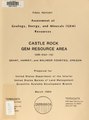
 Geology - energy - mineral resource survey, Northern Malheur Resource Area, Vale District, Oregon (IA geologyenergymin02robi).pdf 4,056 × 2,395, 46 pages; 7.38 MB
-
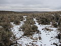
 Grasshopper Flat, Malheur County (36114006104).jpg 5,472 × 2,840; 11.49 MB
-
 Grasshopper Flat, Malheur County (36114007814).jpg 5,472 × 2,172; 9.33 MB
-
 Grasshopper Flat, Malheur County (36114017344).jpg 5,418 × 2,355; 6.91 MB
-
 Grasshopper Flat, Malheur County (36114019144).jpg 5,117 × 2,829; 9.49 MB
-
 Grasshopper Flat, Malheur County (36948440405).jpg 4,696 × 2,775; 10.73 MB
-
 Grasshopper Flat, Malheur County (36948445445).jpg 5,472 × 3,648; 14.61 MB
-
 Grave of Sarah King Chambers.jpg 3,456 × 2,592; 4.16 MB
-
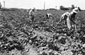 Hoeing sugar beets (5858442020).jpg 3,748 × 2,444; 1.49 MB
-
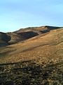
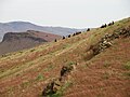 Honeycombs Wilderness Study Area (34486541271).jpg 3,264 × 2,448; 3.77 MB
-
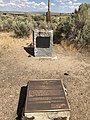
 Inskip Station plaque at Charbonneau Memorial.jpg 4,032 × 3,024; 5.63 MB
-
 Ironside, OR, abandoned building.jpg 4,000 × 3,000; 5.07 MB
-
 Jamieson, Oregon.jpg 4,608 × 3,072; 3.56 MB
-
 Japanese American workers hoeing beets (3387242499).jpg 3,728 × 2,424; 964 KB
-
 Japanese American workers planting onions (5858443900).jpg 3,547 × 2,203; 930 KB
-
 Japanese evacuees harvesting onion seed in Malheur County (3388050454).jpg 3,757 × 2,499; 1,002 KB
-

-

-
-
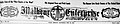
 Malheur Enterprise newspaper nameplate on November 21, 1914, page 1.jpg 1,820 × 431; 649 KB
-
 Mcdermitt nevada-oregon skyline.jpg 4,236 × 2,634; 6.66 MB
-
 Meek's Ruts.jpg 3,456 × 2,592; 2.88 MB
-
 MP 356 Oregon 2019-03-01 082.jpg 4,506 × 2,955; 1.33 MB
-
 MP 359 2019-03-01 078.jpg 4,474 × 2,468; 917 KB
-
 MP 359 2019-03-01 079.jpg 4,491 × 2,468; 980 KB
-
 MP 359 2019-03-01 080.jpg 4,608 × 2,592; 1.97 MB
-

-
 Neal Hot Springs geothermal plant.jpg 3,322 × 2,090; 4.38 MB
-
 NHS main.tif 1,620 × 1,080, 2 pages; 3.44 MB
-
 Nitrate Mountain (3708652688).jpg 1,741 × 2,131; 401 KB
-
 Nitrate vats (3708651986).jpg 2,376 × 1,712; 318 KB
-
 OERR 1608.jpg 4,000 × 2,252; 1.16 MB
-
 OERR 2072.jpg 4,000 × 2,252; 1.41 MB
-
 OERR 3600.jpg 4,000 × 2,252; 1.94 MB
-
 Office of the Malheur Enterprise on January 01, 1910, page 1.jpg 1,862 × 1,393; 1.73 MB
-
 OnionsOnField.jpg 1,572 × 989; 612 KB
-
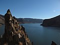
 Owyhee Canyon near Vale, Oregon (14186879794).jpg 3,216 × 4,288; 5.25 MB
-
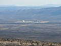
 Owyhee Reservoir Airport.jpg 4,288 × 2,848; 1.4 MB
-
 PillarsOfRomePano1.jpg 7,525 × 1,100; 3.46 MB
-
 Political orientations in Malheur County, Oregon (2009).gif 388 × 288; 5 KB
-
 Pseudoroegneria spicata 01.jpg 1,600 × 1,200; 783 KB
-
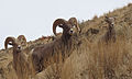 Rams in Oregon (14000475820).jpg 2,790 × 1,665; 2.19 MB
-
 Re-claymation ii - panoramio.jpg 4,320 × 3,240; 2.42 MB
-
 Re-claymation iii - panoramio.jpg 4,000 × 3,000; 4.03 MB
-
 Recreation map of Malheur National Forest, 1916.jpg 3,117 × 3,290; 2.18 MB
-
 Rock Formations in Leslie Gulch - panoramio.jpg 3,888 × 2,592; 4.21 MB
-
 Rock protrusion in eastern Oregon 01.jpg 6,000 × 4,000; 13.35 MB
-
 Rock protrusion in eastern Oregon 03.jpg 5,866 × 3,550; 10.66 MB
-
 Rock protrusion in eastern Oregon wide view.jpg 6,000 × 4,000; 9.84 MB
-
 Scorpions near Basque, Oregon (13999873208).jpg 640 × 480; 105 KB
-
 The Cows Came Home, 2012 - panoramio.jpg 4,320 × 3,240; 4.04 MB
-
 The Quinn River Valley, Blain Davis, Photographer, 2012 - panoramio.jpg 4,320 × 3,240; 4.93 MB
-
 The Santa Rosa Range, Nevada, , Blain Davis, Photographer, 2012 - panoramio.jpg 4,320 × 3,240; 5.32 MB
-

-
 USA Malheur, Oregon age pyramid.svg 520 × 600; 7 KB
-
 USFWS Burning to Benefit an Oasis (16601131169).jpg 3,264 × 2,448; 3.69 MB
-
 USFWS Fire Safety (16599891630).jpg 3,264 × 2,448; 3.51 MB
-
 USFWS Malheur NWR Fire Program Implements Burn on Roger's Wildlife Area (16579984347).jpg 2,738 × 1,956; 2.48 MB
-
 USFWS Prescribed Fire Used as a Tool (16786166092).jpg 3,264 × 2,448; 4.09 MB
-
 Warm Springs Reservoir 3 in Malheur County, Oregon.jpg 6,000 × 4,000; 14.59 MB
-
 Warm Springs Reservoir in Malheur County, Oregon.jpg 6,000 × 4,000; 14.28 MB
-
 Warm Springs Reservoir, wider view, in Malheur County, Oregon.jpg 6,000 × 4,000; 16.32 MB
-
 Wheat Fields After a Storm, Ontario Oregon.jpg 3,472 × 2,604; 3.07 MB
.jpg)
.jpg)
.jpg)


.jpg)
.jpg)
.jpg)
.jpg)


.jpg)


.jpg)
.jpg)
.jpg)
.jpg)
.jpg)

.jpg)
.jpg)


.jpg)
.jpg)
.jpg)
_(cropped).jpg)


.jpg)
.jpg)


.jpg)

.gif)

.jpg)


.jpg)


.jpg)
.jpg)
.jpg)
.jpg)


.jpg)
_on_November_21,_1914,_page_1.jpg)