Category:Map of Europe by Treaty, 1875
Title: The Map of Europe by Treaty, showing the various political and territorial changes which have taken place since the general peace of 1814 (91.) With numerous maps and notes
Author: HERTSLET, Edward - Sir, K.C.B
Shelfmark: "British Library HMNTS 09075.d.18."
Place of Publishing: London
Date of Publishing: 1875 (NOTE that many images from the book suggest a publishing date as late as the 1890s.)
Issuance: monographic
Identifier: 001667758
Media in category "Map of Europe by Treaty, 1875"
The following 82 files are in this category, out of 82 total.
-

-

-

-

-

-

-

-

-

-

-

-

-

-
-

-

-

-

-
-

-

-

-

-

-

-

-
-

-
-

-

-

-

-

-

-

-

-

-

-

-

-

-
-

-

-

-

-

-

-

-

-

-

-

-

-

-

-

-
-

-

-

-

-

-

-

-

-

-

-

-

-

-

-

-

-

-
 Confini Regno d'Italia Veneto 1859 1866.jpg 967 × 777; 202 KB
-

-

-
 South-east frontier of France after the Treaty of Paris, 1814.jpg 1,648 × 2,112; 1.71 MB
-
 South-east frontier of France after the Treaty of Paris, 1815.jpg 1,611 × 2,130; 1.68 MB
-
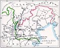
 The map of Europe by treaty - Austria Italy 1866.jpg 1,000 × 1,079; 260 KB
_With_numerous_maps_and_notes%27_(11108902274).jpg)
_With_numerous_maps_and_notes%27_(11110443935).jpg)

_With_numerous_maps_and_notes%27_(11256257335).jpg)
_With_numerous_maps_and_notes%27_(11108088084).jpg)
_With_numerous_maps_and_notes%27_(11108115814).jpg)
_With_numerous_maps_and_notes%27_(11110828196).jpg)
_With_numerous_maps_and_notes%27_(11109585663).jpg)
_With_numerous_maps_and_notes%27_(11110151453).jpg)
_With_numerous_maps_and_notes%27_(11111284275).jpg)
_With_numerous_maps_and_notes%27_(11109103176).jpg)
_With_numerous_maps_and_notes%27_(11108287616).jpg)
_With_numerous_maps_and_notes%27_(11111557033).jpg)
_With_numerous_maps_and_notes%27_(11108381555).jpg)
_With_numerous_maps_and_notes%27_(11111181663).jpg)
_With_numerous_maps_and_notes%27_(11110565915).jpg)
_With_numerous_maps_and_notes%27_(11258811973).jpg)
_With_numerous_maps_and_notes%27_(11108376704).jpg)
_With_numerous_maps_and_notes%27_(11109370225).jpg)
_With_numerous_maps_and_notes%27_(11109267005).jpg)
_With_numerous_maps_and_notes%27_(11109442474).jpg)
_With_numerous_maps_and_notes%27_(11110192463).jpg)
_With_numerous_maps_and_notes%27_(11108589196).jpg)
_With_numerous_maps_and_notes%27_(11109683093).jpg)
_With_numerous_maps_and_notes%27_(11108574054).jpg)
_With_numerous_maps_and_notes%27_(11108807586).jpg)
_With_numerous_maps_and_notes%27_(11109594983).jpg)
_With_numerous_maps_and_notes%27_(11108763105).jpg)
_With_numerous_maps_and_notes%27_(11111402616).jpg)
_With_numerous_maps_and_notes%27_(11108932984).jpg)
_With_numerous_maps_and_notes%27_(11110352975).jpg)
_With_numerous_maps_and_notes%27_(11109519115).jpg)
_With_numerous_maps_and_notes%27_(11110900364).jpg)
_With_numerous_maps_and_notes%27_(11109322986).jpg)
_With_numerous_maps_and_notes%27_(11108518603).jpg)
_With_numerous_maps_and_notes%27_(11108630886).jpg)
_With_numerous_maps_and_notes%27_(11110861536).jpg)
_With_numerous_maps_and_notes%27_(11109114023).jpg)
_With_numerous_maps_and_notes%27_(11109083974).jpg)
_With_numerous_maps_and_notes%27_(11108372034).jpg)
_With_numerous_maps_and_notes%27_(11108651904).jpg)
_With_numerous_maps_and_notes%27_(11111342845).jpg)
_With_numerous_maps_and_notes%27_(11110682553).jpg)
_With_numerous_maps_and_notes%27_(11108836085).jpg)
_With_numerous_maps_and_notes%27_(11110670125).jpg)
_With_numerous_maps_and_notes%27_(11109410273).jpg)
_With_numerous_maps_and_notes%27_(11110971335).jpg)
_With_numerous_maps_and_notes%27_(11110361714).jpg)
_With_numerous_maps_and_notes%27_(11111034876).jpg)
_With_numerous_maps_and_notes%27_(11108044084).jpg)
_With_numerous_maps_and_notes%27_(11109567353).jpg)
_With_numerous_maps_and_notes%27_(11108913983).jpg)
_With_numerous_maps_and_notes%27_(11110277793).jpg)
_With_numerous_maps_and_notes%27_(11110047336).jpg)
_With_numerous_maps_and_notes%27_(11108414223).jpg)
_With_numerous_maps_and_notes%27_(11109697273).jpg)
_With_numerous_maps_and_notes%27_(11109922783).jpg)
_With_numerous_maps_and_notes%27_(11107962694).jpg)
_With_numerous_maps_and_notes%27_(11108682884).jpg)
_With_numerous_maps_and_notes%27_(11110923204).jpg)
_With_numerous_maps_and_notes%27_(11110623063).jpg)
_With_numerous_maps_and_notes%27_(11256964265).jpg)
_With_numerous_maps_and_notes%27_(11110314006).jpg)
_With_numerous_maps_and_notes%27_(11110554646).jpg)
_With_numerous_maps_and_notes%27_(11108499893).jpg)
_With_numerous_maps_and_notes%27_(11109897454).jpg)
_With_numerous_maps_and_notes%27_(11108290306).jpg)
_With_numerous_maps_and_notes%27_(11109061684).jpg)
_With_numerous_maps_and_notes%27_(11108353825).jpg)
_With_numerous_maps_and_notes%27_(11109061923).jpg)
_With_numerous_maps_and_notes%27_(11110341044).jpg)
_With_numerous_maps_and_notes%27_(11109755666).jpg)
_With_numerous_maps_and_notes%27_(11110059245).jpg)
_With_numerous_maps_and_notes%27_(11111295115).jpg)


