Category:Maps by John William Norie
Subcategories
This category has only the following subcategory.
1
Media in category "Maps by John William Norie"
The following 24 files are in this category, out of 24 total.
-
 "La Casses Bank" vigia.jpg 1,094 × 693; 219 KB
-
-
-
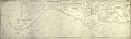
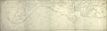
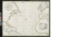
 A General Chart For the purpose of pricking off a Ship’s Track from England (15548000).jpg 45,053 × 20,882; 211.82 MB
-
-
-

-

-

-
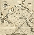 A new chart of the Mediterranean Sea - The Port of Genoa (1797).jpg 1,979 × 2,006; 604 KB
-
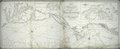
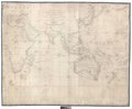
 A new chart of the Mediterranean Sea LOC 2012593220.jpg 22,819 × 9,546; 28.28 MB
-

-

-
 Beryozovye Islands. A new chart of the Gulf of Finland &c.tiff 561 × 463; 761 KB
-

-

-

-

-

-

-

-

-
-


.jpg)


.jpg)

.jpg)
.jpg)