Category:Maps from Constable Hand Atlas
Media in category "Maps from Constable Hand Atlas"
The following 19 files are in this category, out of 19 total.
-
 India in 1893, geological features.jpg 2,340 × 2,958; 6.06 MB
-
 Indian Railway network 1893.jpg 985 × 1,273; 242 KB
-
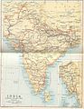
 IndiaPolitical1893ConstablesHandAtlas.jpg 1,318 × 1,027; 341 KB
-
 Key to Section maps, plates 22 to 36, of the Indian Empire.jpg 1,398 × 1,072; 435 KB
-
 Map of Bombay from maps of constable' 1893 hand atlas.jpg 1,271 × 1,751; 444 KB
-
 Map of Calcutta from maps of Constable's 1893 Hand Atlas.jpg 1,296 × 1,726; 548 KB
-
 Map of Delhi from mpas of Constable's 1893 Hand Atls.jpg 979 × 1,303; 208 KB
-
 Map of Luknow from maps of constable' 1893 hand atlas.jpg 1,231 × 955; 216 KB
-
 Map of Madras from Maps of constable 1893 Hand Atlas.jpg 1,316 × 1,756; 506 KB
-

-
 MAPS FROM CONSTABLE'S 1893 HAND ATLAS - 2.jpeg 1,021 × 1,339; 1.06 MB
-
 MAPS FROM CONSTABLE'S 1893 HAND ATLAS - 4.jpeg 1,336 × 1,751; 988 KB
-

-

-

-

-
 Plate 32. Sect. XI- Central Provinces maps from Constable 1893 Hand Atlas.jpg 1,766 × 1,440; 808 KB
-
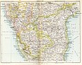 Plate 34. Sect. XIII- Madras, Mysore and Goa maps from Constable 1893 Hand Atlas.jpg 1,736 × 1,376; 830 KB
-


.jpg)


