Category:Maps of 12th-century Asia
Media in category "Maps of 12th-century Asia"
The following 15 files are in this category, out of 15 total.
-
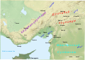
 Asia minor 1140.jpg 1,078 × 1,164; 566 KB
-
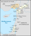
 Asia Minor and the States of the Crusaders.svg 250 × 272; 651 KB
-
 Karta orienten 1190.jpg 1,642 × 942; 583 KB
-

-

-
 Asia Minor and the States of the Crusaders.jpg 1,200 × 1,282; 364 KB
-
 Cilicia.svg 2,508 × 1,789; 585 KB
-
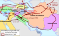
 Ghaznavid empire 1100 ad.jpg 1,352 × 794; 875 KB
-
 Mainland Southeast Asia 1100 CE.png 1,800 × 1,800; 2.7 MB
-
 Map Crusader states 1102-en.svg 591 × 690; 82 KB
-
 Map Crusader states 1190-nl.svg 978 × 1,330; 1.04 MB
-
 Orient Mejan (sègles XIII-XIV).png 655 × 397; 153 KB
-
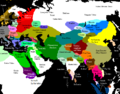 Premongol(2).png 752 × 590; 53 KB
-
 Syrien under korstågen.jpg 978 × 1,743; 632 KB
-
 Tresena Crosada.png 412 × 605; 70 KB


_-_Geographicus_-_AsienXIXII-spruner-1855.jpg)
_p213_1099_TO_1187_A.D._PALESTINE,_TIME_OF_THE_CRUSADES,_JERUSALEM_UNDER_THE_LATIN_KINGS.jpg)


.png)
.png)

